Wrangell St. Elias National Park Day Tours & Attractions
Show Map
Day Tours & Attractions
Flightseeing Tours View All
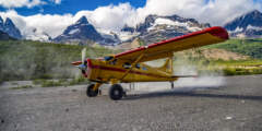
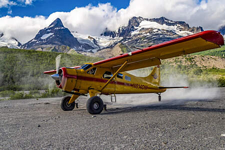
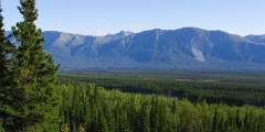
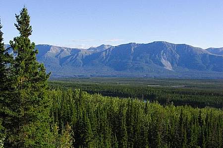
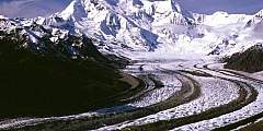
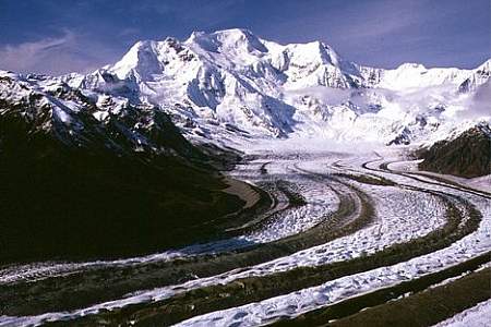
If you want to get a true sense of the 13 million acres within Wrangell-St. Elias National Park — which has a mere 100 miles of roadways — start with an aerial view. Since 1992, Wrangell Mountain Air has been offering safe and fascinating tours of this remote kingdom, which boasts North America’s largest assemblage of glaciers as well as its largest collection of peaks above 16,000 feet. Choose from three main tours.
Year-round air service from Glennallen, Alaska. Short on time? Check Alaska’s largest national park off your list with a flightseeing tour that includes a landing in the wilderness of the park. Traveling to McCarthy / Kennicott? Travel like the locals and hop on a mail plane flight. See how backcountry mail is delivered and enjoy speedy transportation to McCarthy. Or, opt for their scheduled air service. Both have departures from Anchorage and ...more
Guided Hiking View All
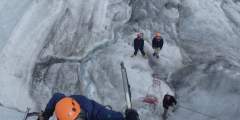
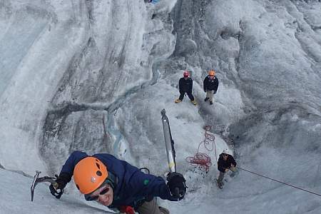
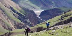
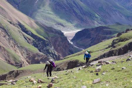
If you’ve never walked on a glacier, this is your chance. Going with experienced guides, you’ll leave from Kennicott, hike two miles, and spend the next several hours on the Root Glacier, safely exploring the blue ice, blue pool, canyons, and moulins of this extraordinary natural phenomenon. Choose a half- or full-day tour and learn all about natural and human history from your expert guides along the way. Or ramp up the excitement by going ice ...more
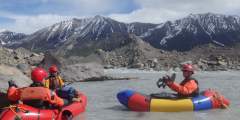
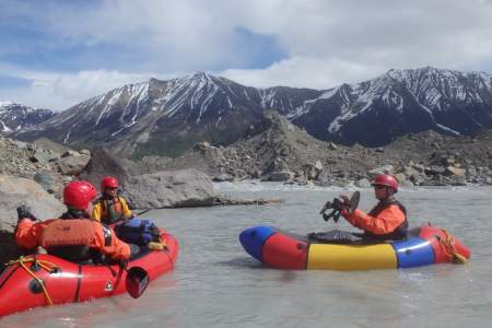
Experience the thrill of trying out a new sport: packrafting. Led by expert guides, you’ll leave from the town of Kennicott out to the Alaskan backcountry, then strap a raft to your back (it’s under 9 pounds) and set off on an interpretive walk down to a lake. Then unpack the raft and put in the water. You’ll learn how to use and maneuver these unique boats in Class I‑II water, and even have the possibility of taking on some Class III rapids. ...more
Explore the Alaskan wilderness while carrying your pack and camping out — it’s a way to truly get in touch with nature. Choose a 1‑night or 2‑night trek leaving from the town of Kennicott — your expedition will be led by expert guides, who will take you on hikes that can wind past gorgeous lakes and stunning waterfalls. Work with your guide to personalize your adventure — they know the must-see highlights of this area and can fill you in on the human ...more
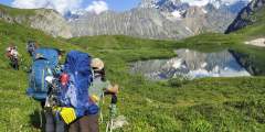
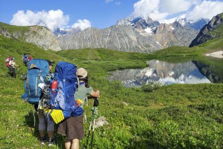
Fly in and out of remote locations in the gorgeous Wrangell-St. Elias National Park and experience the true wilderness of the Alaskan backcountry. Keeping it minimal and unplugging completely, you’ll sleep in a tent and wake up refreshed and exhilarated by the sights and sounds of these raw wilds. Moderate mini-Backpacking excursions for beginners, or point-to-point hikes for experienced backpackers that match your abilities.
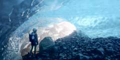
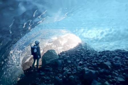
A third of Wrangell — St. Elias National Park is covered in glacial ice, making it one of the easiest places to access a glacier in Alaska. Strap on the provided crampons and explore the stunning features of the glacier with expert guidance — rivers and waterfalls, crevasses and blue pools wait to be discovered. Or, take on the challenge of scaling the dramatic icy walls of a glacier on an ice climbing trip.
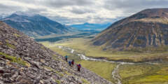
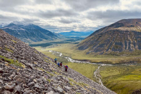
Small group backpacking and basecamp hiking adventures in Denali, Gates of the Arctic, Wrangell St. Elias, Kobuk, and Lake Clark National Parks. Beginners with a high level of fitness are welcome but having completed at least a few backpacking trips is recommended. Your guides are highly trained trip leaders who have global mountaineering experience and wilderness medical training.
Rafting Tours View All
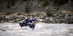
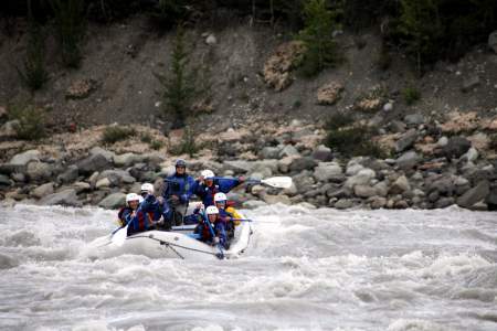
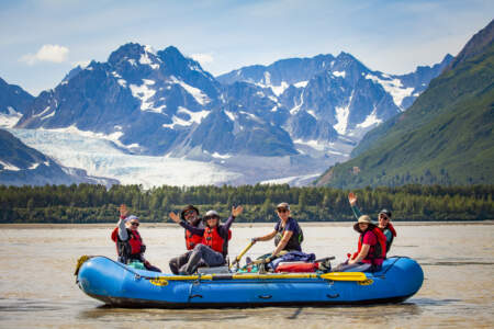
Taking to the rivers is such an excellent way to explore Wrangell St. Elias National park, and this operator out of McCarthy offers day trips that let you embrace the wonders of the park in a comfortable, hands-on, way. Both day trips are four hours. One allows you to paddle around a glacial lake, relax, and take in the scenery. The other takes it up a notch by floating downriver through class 2 and 3 rapids after a brief paddle around the lake. ...more
Sprawling Wrangell-St. Elias National Park has huge mountains, North America’s largest concentration of glaciers, and thousands of rivers — but just two roads. That’s why taking to the local rivers is such an excellent way to explore the park: this operator out of McCarthy offers multi-day adventures that embrace the rugged wonders of the park, while keeping you comfortable enough so that you relax and enjoy it.
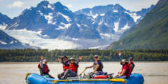
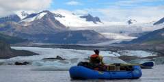
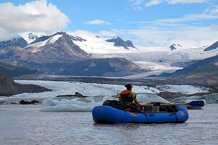
Raft the gorgeous glacier-fed rivers and iceberg-filled lakes of the Alaskan backcountry out of McCarthy, an historic town in the heart of America’s largest national park, Wrangell-St. Elias. Going with St. Elias Alpine Guides — the park’s longest-operating rafting company — is a great way to experience the wilderness on everything from half-day outings to 15-day expeditions. No experience is required, and all food and gear are provided!
Experience the thrill of trying out a new sport: packrafting. Led by expert guides, you’ll leave from the town of Kennicott out to the Alaskan backcountry, then strap a raft to your back (it’s under 9 pounds) and set off on an interpretive walk down to a lake. Then unpack the raft and put in the water. You’ll learn how to use and maneuver these unique boats in Class I‑II water, and even have the possibility of taking on some Class III rapids. ...more
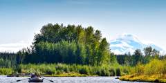
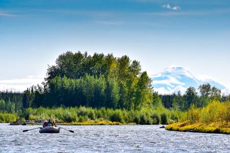
Exploring the rivers of Copper Center, around 4 hours from Anchorage and right on the edge of gorgeous Wrangell-St. Elias National Park, brings opportunities for everything from mild floats to Class III and IV rapids. Since the Copper River Basin is a little more remote than other areas, you’ll be able to truly appreciate the wilderness as you enjoy a relaxing day on the water.
Walking Tours View All
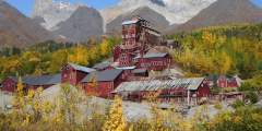
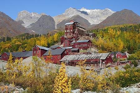
This abandoned copper mining camp is a National Historic Landmark District. Established in 1903, Kennecott Mining Corporation operated 5 mines in the area. Kennecott became a bustling mining camp filled with miners and their families. By 1938, Kennecott was a ghost town. This guide shows the self-guided walking tour points.
The wilderness town of Kennecott — once home to a bustling mining operation — was suddenly abandoned in 1938 when the Kennecott Copper Corporation ceased operations. Now you can tour the ghost town with an expert: St. Elias Alpine Guides was granted special permission as the only concessionaire with the National Park Service to take travelers not only around the town, but also inside the buildings.
Visitor Information Centers View All

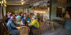
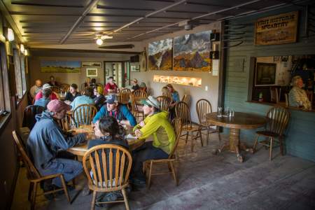
Owned and operated by the National Park Service, this hall often hosts speakers, movies, potlucks, yoga, music, weddings, and other community events. You’ll likely see flyers around town about these events, which are usually held for no charge (though they may request donations). If there is something going on during your visit to town, don’t be shy; it’s worth your while to find out what’s happening. And check in at the NPS visitor center to see ...more
Driving into McCarthy you’ll see a sign for the NPS kiosk on the left. This is a great place to get oriented to the McCarthy and Kennicott area as well as make the most of your visit here. The information kiosk is open daily during the summer and has friendly park rangers and volunteers to answer questions about the McCarthy and Kennicott area as well as give you information about parking and shuttle service. This is a also good place to use… ...more
Walking down the main street of Kennecott, you can’t miss the National Park Service visitor center on the left, housed in the historic general store and post office.Stop in and learn about the history: The story goes that when the last train left Kennicott in 1938, people had to suddenly abandon their lives with only a few hours of warning. Until the 1970’s you could still come and stock up on beans, flour, and other staples left behind.You’ll… ...more

In a national park with some 13 million acres, deciding on a spot for the visitor center can’t be easy. But the National Park Service found a great location in Copper Center, where you can get information on hiking trails, backcountry expeditions, flightseeing, and guiding companies, along with books, brochures, and a relief model of the park’s mountain ranges
Museums & Cultural Centers View All
You can’t escape the town’s historical dynamic, and this museum is the best place to get the inside scoop on its past, including the copper rush that happened between 1900 and 1938. The museum building itself is a piece of history, having once been the railw¬ay depot. Check out the pictures of railway construction — 196 miles of track from Cordova — which are alone worth the visit. You’ll also find photos and artifacts that give you an idea what… ...more
Fairs & Festivals View All
Experience a small-town 4th of July event complete with a parade and a series of fun games like a hula-hoop contest, nail-pounding contest, and tug of war.
Parks & Trails View All

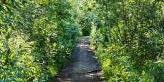
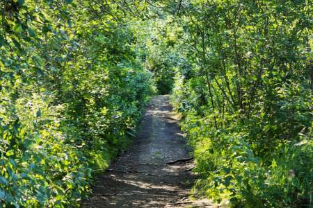
If you’ve spent the day in Kennicott, on the glacier trail, or in the mountains and still can’t get enough of the outdoors, skip the shuttle ride down the hill to McCarthy and take this nice 1.5‑hour walk. The Wagon Trail cuts off the main road just to the right of the St. Elias Guides office.
This route begins at the Park Service and Information Station. Follow the flags, and they will lead you to an unmaintained footpath. This trail requires a lot of bushwacking and the footholds are not strong, especially after the first four miles.
This spectacular backcountry route connects the Lost and Trail Creek drainages via a 6000’ pass. Explore these trails as day hikes from Nabesna Road or as one big loop in either direction over 3 to 4 days. Trail Creek and Lost Creek were used by generations of Ahtna people, who hunted moose and trapped gophers and porcupine. In the 1930s a few cabins were built at Lost Creek and the Ahtna residents made a living hunting, fishing and selling… ...more
An easy trail, about 0.6 miles long, that will take about 1 hour to hike and leads you to excellent views of Child’s Glacier. Important note: While the Forest Service still maintains it, you can’t get here by car, as the Copper River highway is washed out at Mile 36. You can only access the trail by hiring a boat or a plane from town.
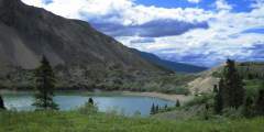
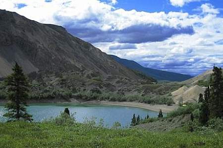
Highlights: Wildlife, open tundra, spectacular scenery. Soda Lake was created by a large landslide, most likely in response to an earthquake and past movement along the Totshunda Fault. The fascinating terrain near the outlet of Soda Lake resulted from the landslide, creating a topography which contrasts from its surroundings. The lake now seeps through this landslide rubble.Hazards: Creeks, especially Soda Creek, may be high on hot sunny… ...more
This is a trail with access to Copper Lake. Copper Lake has opportunities for Lake Trout, Grayling, and Burbot fishing. The first 2.5 miles are suitable for hiking, then the trail crossses Tanada Creek, which can be high and fast, and trail conditions deteriorate.
Looking for a mellow 3- to 4‑hour walk and a nice spot to relax with a book or a journal? Check out McCarthy Creek. To get here, just walk straight through McCarthy’s Main Street, past Ma Johnson’s Hotel (on the left), down the hill, and past the Wrangell Mountain Center.
By the time you reach this trailhead you’ve already had the pleasure of gazing upon the Chrystalline Hills . The Wrangell Mountains contain a wide variety of mountain compositions. They were formed millions of years ago by classic plate-tectonic thrusting. If you look closely, you should be able to see folds in the rock. While being formed, these young mountains were shaken up by serious volcanic activity. Things heated up when the terrain… ...more
Camp right at the toe of the Root Glacier, in a National Park Service camping area. This is a great way to experience the glacier without the traffic of hikers and tourists that pass through during the day. The area has a few camping spots carved out of the hillside, as well as bear boxes (and there’s another just past Jumbo Creek). Jumbo Creek is the boundary for camping – with no permission to camp before you cross it. Be wary of bears: In… ...more
To get a little further away from civilization, you can also camp at the end of the Root Glacier trail, about 4 miles from Kennecott. This is hardly a traditional campground; there are a few creative spots to pitch a tent, one of which is on the trail itself. There’s also a bearproof food storage box, since this is definitely bear country. But few people and amazing views make the hike out here worth it. You’ll know you’re at the end of the… ...more
Liberty creek is accessible via Liberty Creek Campground. The campground surrounds a clearwater creek at the bottom of a beautiful waterfall. Campgrounds are on either side of the creek in a surreal setting.
The trail begins at the Skookum Volcano trailhead (Mile 36.8 Nabesna Road) and follows until the pass (see SkookumVolcano trail descriptionfor more information). From the pass on, there is no trail, and one must pick one of two routes.
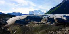
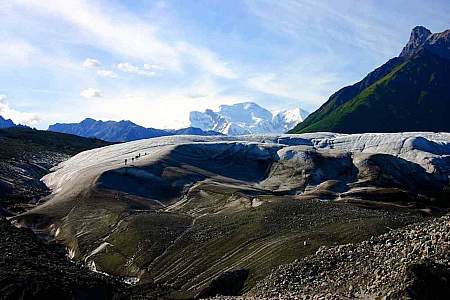
Located in Wrangell-St. Elias National Park, this 4.4‑mile trail takes hikers through a rugged landscape of ice, rock, and streams. It’s a moderately challenging hike that offers stunning views of the glacier and surrounding mountains.
Access: Trailhead is located at the end of the maintained portion of the Nabesna Road, Mile 42. As you near the end of the maintained portion of the Nabesna Road, you will reach private property owned by the Ellis family, who operate Devil’s Mountain Lodge, established here in the 1950s. Please respect their privacy and take care not to park on their property or private air strip. Continue driving on the road through the Ellis property.… ...more
At mile 14.5 McCarthy Road, turn left on the access road and follow it 2.5 miles to Nugget Creek and Dixie Pass trailheads. These remote trails offer visitors the chance to explore the wilderness and embark on an adventure they will never forget!Ask a park ranger for more information and trail descriptions.
This hike is a great opportunity to prolong the Crystalline Hills experience. It’s relatively easy traveling and gets you some nice views of the mountains looming above, as well as looking south towards the Chugach Mountains. About 15 – 20 minutes of hiking will get you to a viewpoint worth leaving your car for. This area has long been used by sheep hunters, so if you have binoculars you may want to spend some time scanning these hills. If it’s… ...more
People travel from all over the world for a backpacking trip within Wrangell St. Elias National Park & Preserve. One common misconception is that the more expensive the bush-plane flight, the more impressive the scenery and terrain. It would be more accurate to say that the more expensive the bush-plane flight, the farther away from the airstrip you’re flying. Since the McCarthy airstrip and the 60-mile dirt road to the airstrip are in the… ...more
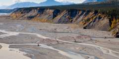
The Nizina River is a classic Alaskan monster — almost 1.5 miles wide. Once stepping out of the forest you may need to walk 20 minutes to reach the river channel currently being used. Walk around and you’ll find here lots of cool rocks, as well as rewarding views of the dramatic Chugach Mountains that you won’t get from McCarthy or Kennicott. You’ll also catch a glimpse of the historic steel bridge once used as part of the route to the gold… ...more
The discovery of gold at Jacksina Creek in 1899 was an exciting find for prospector K.J. Fjeld, but it proved too remote to develop successfully. Other prospectors were persistent though, and in 1925 Carl Whitham found a rich lode on White Mountain. That find, and his subsequent development of the mine, led to the construction of Nabesna Road. At its height, between 40 and 70 men were employed at the mine. It also provided trading… ...more
This historical trail through the woods between McCarthy and Kennicott was the walking/wagon road when the railroad was still running. It’s a nice alternative to walking or biking up the 4.5‑mile-long road between McCarthy and Kennicott, where you’ll find more vehicles and dusty conditions.


Jumbo Mine is located 3,000 feet above Kennecott — get there via a gorgeous and strenuous hike that will leave most people very happy, and very tired. The mine building ruins pale in comparison to the dramatic mountain scenery that surrounds you. The buildings were initially built on a rock glacier, in which loose rock accumulates and is lubricated by frozen water, then moved by gravity. Needless to say, after 80 years, not many buildings are… ...more
This hike takes you up the historical wagon road to the top of the mountain, where you’ll find the ruins of mine buildings. Start by hiking along the Root Glacier Trail until a NPS junction sign points you right up the mountain. You’ll ascend about 2,000 feet (1.5 – 2 hours) before rising above the tree line; even if you go no further, the view is worth the effort. However, you can also continue up another 2,000 – 3,000 feet to the top, where the… ...more
From the trailhead, the trail leads up an alluvial fan, through white spruce forest and alder for approximately 0.8 mile. The trail surface is gravel/cobble and dry.
Follow Root Glacier Trail to its termination at Root Glacier, then continue on past the rockslide to a camping area with a bear-proof food storage box. From here, descend over the top of the moraine, carefully making your way down the rocky slope. At the bottom, you’ll head north off-trail until steep cliffs are towering on your right. Curve around the point and continue on to Erie Lake and the Stairway Icefall, which is a 7,000 ft vertical… ...more
Copper brought people to Kennicott/McCarthy, and gold kept them coming, usually via Dan Creek Road. The Cordova Chamber of Commerce built this road back in 1914 to promote access into the gold-rich interior of Alaska. Today you can use this road to get to the old airstrip, a miner’s cabin at the top of the bluff above McCarthy Creek (a 25-minute walk from McCarthy), and the Nizina River, some 9 miles away. Watch for the bridge over McCarthy… ...more
Getting out to the Kennicott Glacier is the first challenge. You need to hike onto the Root Glacier, cross over the monster rock moraine to your left, cross another tongue of ice on the Root Glacier, then cross yet another monster rock moraine between the Root and the Kennicott glaciers. It’s tricky terrain and not to be taken lightly. When facing down the second moraine, you’ll want to hit the low point that’s close to where the black mud… ...more
The Dixie Pass trail gains over 5,000 feet as it leads you into the alpine. The views are world-class, and there’s always a good shot at spotting wildlife on this hike. It’s best to give yourself 3 or 4 days to fully explore this area, but an overnight is definitely better than not going at all. There are no support facilities here, so bring your own tent, sleeping bag, and supplies because there are plenty of great camping spots near water… ...more
The trail proceeds in a northeast direction towards the hills. The trail is an ATV route, and as such there are some muddy areas where you may be required to walk off the trail. The beginning of the trail goes through the valley bottom with low tundra vegetation. Views are great. As the trail continues, the forest surrounds the trail with spruce, alder, willow and wildflowers.
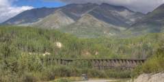
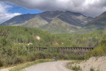
Coming around the corner after milepost 28, you can’t help but notice the Gilahina Trestle. There are 85+ miles of bridges and trestles within the 196 miles of rail between Cordova and Kennicott. Building them was a big job. The Gilahina Trestle is visual confirmation of the size of job it was, standing 80 – 90 feet high and 880 feet across. The crew used a half-million board-feet of lumber and completed the job in eight days.
A small pullout in the left provides access to a trail to Strelna Lake. The Alaska Department of Fish & Game stocks this lake with rainbow trout.
Historic Park or Site View All
This abandoned copper mining camp is a National Historic Landmark District. Established in 1903, Kennecott Mining Corporation operated 5 mines in the area. Kennecott became a bustling mining camp filled with miners and their families. By 1938, Kennecott was a ghost town. This guide shows the self-guided walking tour points.
The Copper River and Northwestern Railway used to serve the miners in this area in the early part of the 20th century, but the trains stopped rolling in 1938, and cargo planes became the only way to get freight in and out. This 14 X 18 mail cabin was built in one day in 1948 by employees of the Chititu mining company. It’s held up pretty well over the decades — it had to be rehabbed in 1998 to replace some rotting logs, but it still functions as… ...more
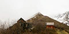
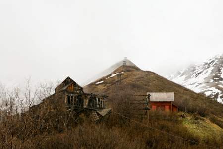
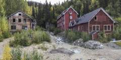
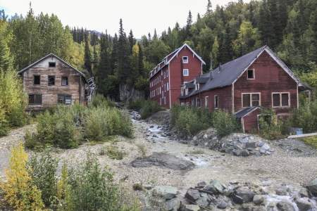
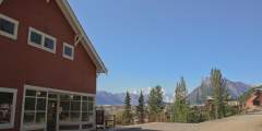
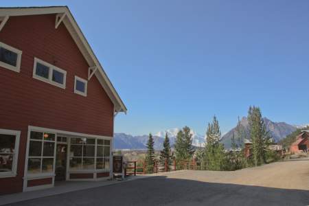
The first two things visitors notice about Kennecott are the spectacular views and the town itself…in that order. The combination of dramatic scenery and strange mining town makes for a unique experience. Give yourself a couple hours to explore and take it in.
Talk about an authentic pioneer town. Time seems to have stood still on McCarthy’s Main Street, which is unpaved, only a few hundred yards long, and lined with classic buildings and memorabilia.Some visitors walk through McCarthy and complain that there’s nothing to do — and that’s exactly why folks like living here. But while you may not find much activity, you will find a lot of history: In the town’s heyday there were several hotels,… ...more
If you’ve spent the day in Kennicott, on the glacier trail, or in the mountains and still can’t get enough of the outdoors, skip the shuttle ride down the hill to McCarthy and take this nice 1.5‑hour walk. The Wagon Trail cuts off the main road just to the right of the St. Elias Guides office.
Thursday evenings are open mic night in McCarthy. It’s a great chance to rub elbows with some locals and fellow travelers and get a taste for the neighborhood. All are welcome! Bring your guitar, harmonica, and voice – or just your eyes and ears. Occasionally on Fridays and Saturdays there’s a band playing after 8:30 p.m. Be on the lookout for special events that are free and open to the public.
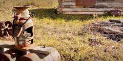
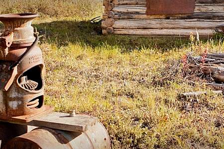
Old railroad building alongside the road.
This historical trail through the woods between McCarthy and Kennicott was the walking/wagon road when the railroad was still running. It’s a nice alternative to walking or biking up the 4.5‑mile-long road between McCarthy and Kennicott, where you’ll find more vehicles and dusty conditions.
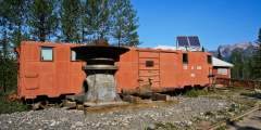
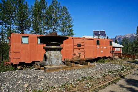
Across the street from the museum is a short path leading to the old railroad turntable used to flip the engine around so it could push the train the 4.5 remaining miles up to Kennicott. Look for a wooden sign across the street pointing the way. Two or three people can get it moving again. It’s a great activity for kids looking for a short but unique ride.
At this point in the drive you may need something to talk about.The Athabascan people traveled along the current McCarthy Road corridor to access their summer hunting camps in the Chugach Mountains. Their trails took them to prime mountain sheep country, as well as to some of their favorite spots for harvesting copper. One copper nugget taken from Dan Creek, almost pure and as big as a refrigerator, now sits in a museum at the University of… ...more
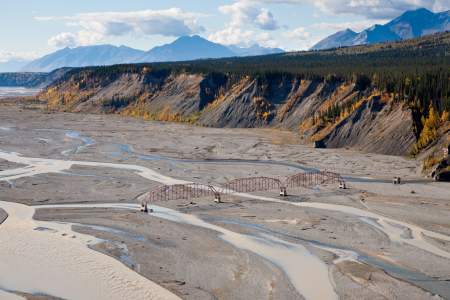
Built in the 1920s, this bridge helped prospectors cross the Nizina River and reach the gold camps at Chititu Creek and Dan Creek. The glacier-dammed lake near here caused flooding with some regularity — and as result, would wash out the bridge with some regularity.
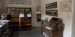
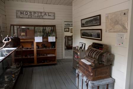
The post office actually had better service back then than today! Today, the mail comes in a couple times a week. Back then, the train brought it almost every day. Workers from the Lower 48 or foreign countries would come here to send letters to loved ones but also to send their paychecks back home. They made about $6/day and had to pay the company $30/month for room and board. If they didn’t blow the rest down in McCarthy, they would have ...more
Replaced by a footbridge in 1997, this tram used to be the only way to get across the Kennicott River. Today you can take the Kennicott River Footbridge to begin your adventure in McCarthy!