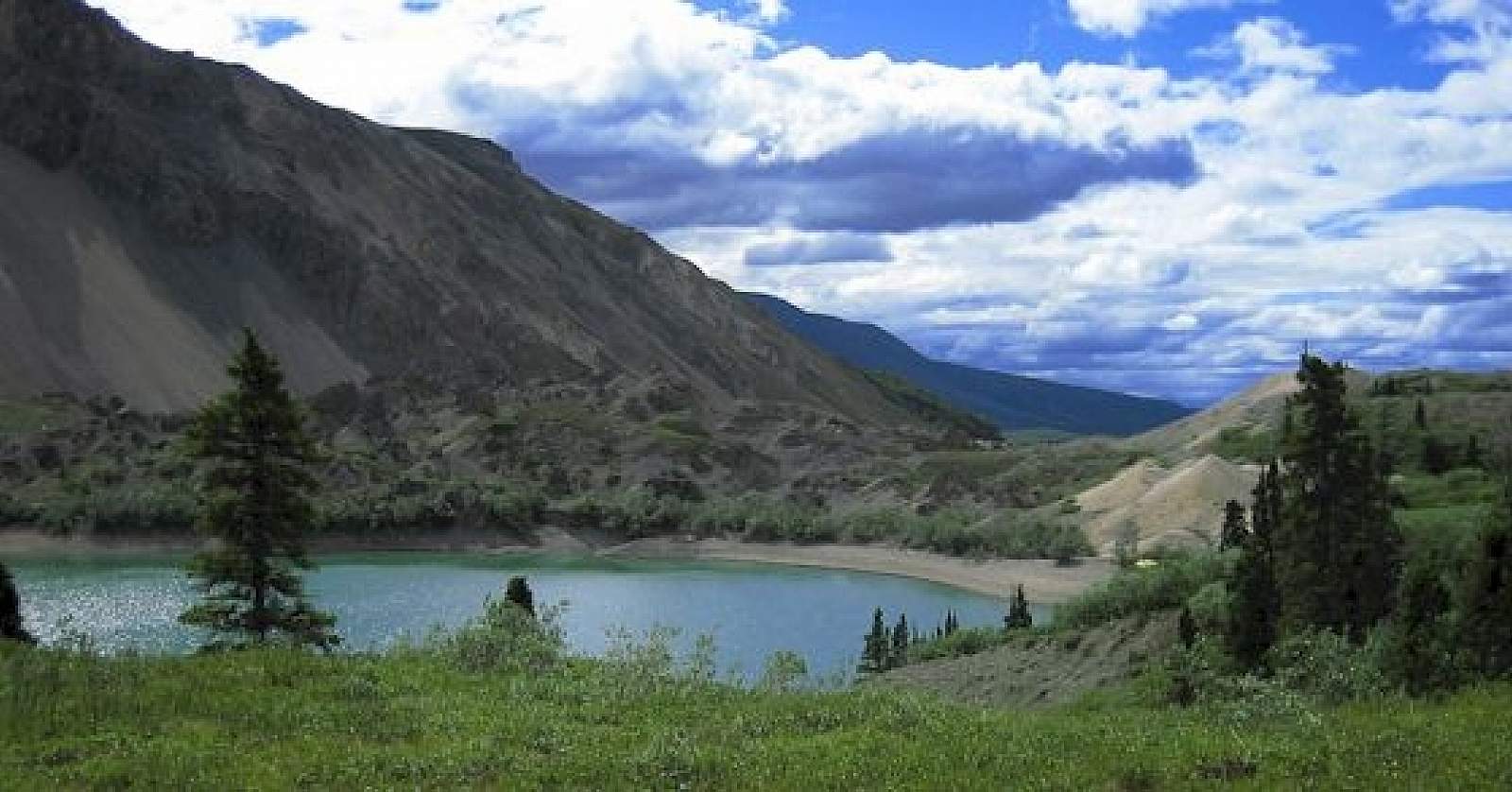
Highlights: Wildlife, open tundra, spectacular scenery. Soda Lake was created by a large landslide, most likely in response to an earthquake and past movement along the Totshunda Fault. The fascinating terrain near the outlet of Soda Lake resulted from the landslide, creating a topography which contrasts from its surroundings. The lake now seeps through this landslide rubble.
Hazards: Creeks, especially Soda Creek, may be high on hot sunny afternoons or after heavy rains.
Notes: Bears are present in the area. Proper food storage is required. Bear-resistant food containers are available at any park visitor center.
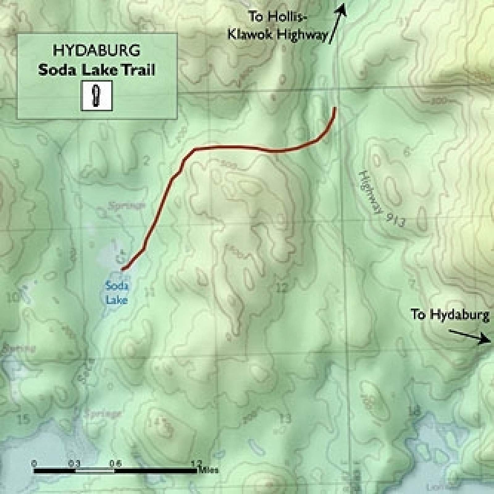
Route: Approximately 100 yards past Lost Creek, turn left into the parking area. The turn-off is not marked. However, a trailhead sign is visible from the road at the first of two parking areas. Please park in one of these parking areas. Follow the ATV trail north through the woods, along Lost Creek. The trail occasionally crosses Lost Creek, although you can follow faint trails through brush at times to stay on the east side of the creek.
After 2 miles, the Big Grayling Lake ATV trail departs Lost Creek floodplain and heads east from Lost Creek, meandering through spruce forest, open tundra, and sedge tussocks. Pick up water at Lost Creek; it may well be your last flowing water until you near Soda Creek, some 8 miles later. The ATV trail can be very muddy in places. The area around the lake may be wet, depending on seasonal rains. There are two parcels of private land on Big Grayling Lake, 80 acres located on the northwest corner of the lake and 40 acres on the east corner.
Cabins and buildings there are privately owned. Please respect private property by remaining on the trail and not camping in the area.
Past Big Grayling Lake, the trail veers left, through spruce forest for about one mile. The trail then follows Platinum Creek as it drops southeast for about 2 ½ miles. It is easy to lose this trail in places in the Platinum Creek wash. Watch for it heading out of the wash into the bordering forest from time to time. The trail leads to the confluence with a creek draining the Karen Lakes area. The depths of Platinum and Soda Creeks can vary, depending on recent rainfall amounts, time of day, and temperatures. Soda Creek is a more reliably flowing creek.
After crossing this unnamed creek, it is another ¼ mile to Soda Creek and the beginning of the Soda Lake ATV trail. Follow the recreational ATV trail upstream along the west side of Soda Creek for approximately one mile, at which point signs indicate the end of recreational ATV use. Continue hiking north along the west side of the creek for about another mile to a major creek junction marked by red cliffs between the two forks of the creek. (Although recreational ATV use is prohibited in this section of the creek, you may encounter ATV tracks from subsistence users. You should be able to avoid crossing the creek until you reach the junction.) Take the east (right) fork of the creek, which will require crossing Soda Creek.
A mineral spring deposit is located on the north side of the east fork 100 or so yards past this junction, and can be identified as a rounded white mineral deposit. Dall sheep tracks abound in the area, as sheep are attracted to the mineral-laden earth around the dry springs.
From the mineral spring, backpackers have two route choices. The easier option requires locating the horse trail, which departs Soda Creek approximately 300 yards upstream of the red cliffs marking the creek junction and 200 yards upstream of the mineral spring. This somewhat brushy trail heads uphill from a small campsite on the north side of Soda Creek into a landslide area and winds its way approximately ½ mile to the northwest corner of Soda Lake.
Alternatively, if you miss this unmarked junction, you can continue up Soda Creek to where it ends in a steep scree slope. Climb the steep, loose scree and rubble to a flat area above the southwest end of Soda Lake and then descend about 100 feet to the lake. Good camp and kitchen sites on the northwest end of the lake can be reached by walking the lake’s shoreline to the north.