Birding Locations in Nome
Nome is becoming a well-known as a treasure for birders. The city is bounded by tundra on three sides and the Bering Sea coast on the other. Once the ice begins to break up, migration begins. Virtually the entire area of the Seward Peninsula that is accessible by road from Nome is comprised of extremely valuable nesting areas for many bird species, including most North American waterfowl. You’ll even find quality birding on wetlands and beaches right in town.
Aside from the variety of species in the area, there are a few things that make birding here unique:
More color – It’s like you’ve seen a whole new bird when you finally spot a familiar species in its colorful breeding plumage (especially the males).
Accidentals and foreigners – Siberia is close, which means you might see species that aren’t normally found in the U.S., even in Alaska.
Fewer neck aches – Males marking their territory usually sit at the tops of trees. But in Nome, the tallest “trees” are generally willow and alders. This provides a better view and you don’t have to crane your neck so far. Sometimes they are right at eye level.
Best time for Birding
Birding on the Nome Road System
Birding in Town
Guided Options: Birding on a Budget
What to Know Before You Go
Best time for Birding
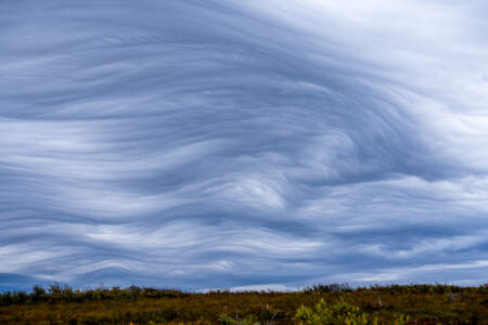
Spring and break-up come late to Nome, near the end of May. The best time for birding in and around Nome is normally in early June. At that time, the melting ice along the southern Seward Peninsula forms migrant traps and birding from the road system is most productive. This season is called break-up in Alaska. Occasionally roads are closed because of flooding or washouts. Travelers should plan for all sorts of weather, but it is this changeable climate that brings in the rare migrant species and settles them into small ponds to wait for better flying weather. This is also the time of year when changing weather systems bring large numbers of accidentals to the area. Snow Buntings and McKay’s Buntings are best seen during the winter through early spring at a couple of feeders in Nome and Icy View (two miles north of Nome on the Nome-Teller Road). In March and April, Snow Buntings are plentiful around town but by summer scatter to nesting habitat, while McKay’s Buntings leave the Seward Peninsula for breeding. Many species take advantage of the long days and abundant food sources to nest and raise young. Birding is good into mid-August when migration is in full swing.
Birding on the Nome Road System
An epic birding adventure awaits on the Nome road system, with different species to be found along the three main roads going out of Nome. This is a trip of a lifetime for many birders, who are often surprised that they can add dozens of new species to their life lists in just a few days. Here are the most popular spots on each of Nome’s three main road systems:
Safety Sound Lagoon and Council
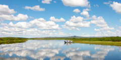
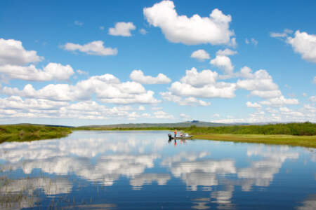
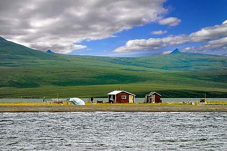
Serious birders must take in Safety Sound, where thousands of migratory birds feed and rest in late May. Less than twenty miles from Nome on the Nome-Council Road, Safety Sound is a migrant trap before breakup. Observers have noted Emperor Geese, and Stellar's Eiders in this area. Off-shore in open patches of water, called leads, ringed seal often bask on ice ledges. These leads also concentrate migrating waterfowl: Scoters, Eiders, Harlequin Ducks, Long-Tailed Ducks, Arctic and Pacific Loons and, occasionally, Yellow-Billed Loons. Tufted and Horned Puffins, Common Murres, and Pelagic Cormorant are are all possibilities in this bird rich area. The terminus of this road is Council, and is the only place accessible from Nome where boreal species may be found.
Kougarok Road
The star of this route has got to be the Bristle-thighed curlew, a vulnerable species that nests in Alaska and winters in Hawai’i and other warmer places. You can usually find Bristle-thighed curlews by parking at Mile 72 and hiking up the hill to your left. Though not steep, the hike is somewhat strenuous and can be marshy in places, so wear boots and take your time. Curlew nest on the slopes of the hill. Whimbrels, nearly identical in appearance, also make this hill their home, so be familiar with the calls and field marks of both species. Elsewhere along the Kougarok Road, cliffs provide nesting habitat for Gyr Falcon, Golden Eagles, and Peregrine Falcons. The high, rocky ridges also boast nesting Wheatears. Bluethroats can be found in brushy areas along the road, and Wandering Tattlers are often seen foraging along creeks and rivers, so be sure to stop at bridges to look around.
Wooley Lagoon
The target species for a drive on the side road to Woolley Lagoon is the Black-Bellied Plover. This is the only place on the road system where this species can reliably be found. The 8-mile side trip begins at Mile 40 of the Nome-Teller Road, and ends at the lagoon, which is on private property. Visitors are asked to stay within 50 feet of either side of the road.
Birding in Town
In Nome without a car? You can have a successful birding adventure right in town, on foot or by taxi. Many species are attracted to Nome’s ponds, wetlands and beaches. These spots can be worth the walk; Cemetery Pond, East End Park, and the Mouth of the Nome River.
Guided Options: Birding on a Budget
If you’re coming to Nome and have an interest in birds, chances are that you’ve already booked a guided tour with a major birding organization. These trips offer knowledgeable guides and fellow travelers who are also birding enthusiasts.
However, they can also be expensive. If you’re looking to bird on a budget, or if you’re just getting into birding, you can still have a great time in Nome, spotting many species on your own at the spots listed below, or with the assistance of affordable local guides.
- The Northwest Campus of the University of Alaska Fairbanks offers local birding field trips each spring for a much lower fee than you’ll find with dedicated birding outfits. For less then $50, you get a day-long (7 am to 7 pm) guided trip. These are usually on the last weekend in May and first weekend in June. Destinations typically include the coast road to Safety Sound and beyond on one day and to Mile 72 of the Kougarok Road and beyond on another day. It’s typical to spot between 65 and 80 species on each of these field trips.
Before you go
- If you’re planning a trip to Nome in the height of birding season, be sure to reserve lodging well in advance. Large birding groups are organized months ahead of time, so independently travelers are encouraged to book early.
- Download the Nome Bird Checklist, which serves both as a guide and as a log of species you observed.
- Read postings in the Beringia Birders Yahoo Group for insight into what other birders are finding in Nome and the surrounding areas.
- Check the “birding board” at the Nome Visitors Center and at the Aurora Inn counter to see what species have been spotted lately. Be sure and report your own sightings at these spots, too.
Show Map
Points of Interest
Birding in Town

The bridge marks a mixing zone where fresh river water meets tidal salt water and turns brackish. This creates a blend of water types and habitats and attracts many different birds to areas of open water or the mud-bar edges of islands. Look for geese, cranes, shorebirds, and gulls in good numbers, even unusual species like Arctic loon, red knot, black-tailed godwit, red-necked stint, ivory gull, and white wagtail. Also spot spawning salmon. ...more
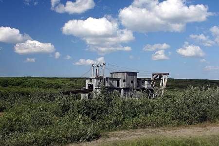
Bordering the cemetery hill to the north, at the intersection of Center Creek Road and the west extension of the Nome ByPass Road, a large man-made pond from placer mining operations that is slowly becoming vegetated is a good place to find a few species of nesting waterbirds. Red-necked grebe, glaucous gull, greater scaup, northern shoveler, and green-winged teal may be found near the center and edges of the pond.

These stops on the east edge of Nome (described in more detail in the Council Road section) offer freshwater ponds adjacent to the marine water coastline that attract a wide variety of spring migrant waterbirds and shorebirds as the ice is melting in late May and early June. The area is worth checking regularly because arriving species often make a short stop before moving inland. By mid-summer, early departing shorebirds gather to feed and ...more
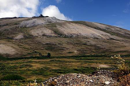
Anvil Rock perches above Nome, an early landmark for gold miners and an easy hike for those who want to take in spectacular views of Nome, the Bering Sea, and the Kigluaik Mountains. Its resemblance to a blacksmith’s anvil generated names for many nearby landscape features, including Anvil Mountain and Anvil Creek. The hike also promises a good chance to see musk oxen, birds, and maybe even reindeer or red fox. ...more
Returning south of the road to the airport (Seppala Avenue) and west of the Nome port, the beach front area offers a good view of the marine waters of Norton Sound and the barge docking area built of quarried rock from Cape Nome. Depending on the season, the open ocean view will be punctuated with passing flocks of eiders, brant, scoters, murres, auklets, cormorants, and other seabirds.
Look for loons, mergansers, gulls, terns, and kittiwakes where the Snake River flows into the Nome harbor area, either close to the beach or in the salt and fresh water mixing zone. When ice covers the harbor during the spring thaw, the plume of river melt attracts a mixture of arriving species seeking open water near the coast. Many birds stay in the area throughout the summer, making this an important local hot spot for birdlife.
Skirt the harbor and walk toward the west side of the port area along Seppala Avenue, and you’ll cross the culvert where Dry Creek flows into the harbor. Upstream is a wide area of lowland vegetation. This area is subject to salt water intrusion during wind driven high tides, affecting the wetland habitat as it reaches the side slopes of tundra and willow shrubs. Puddle ducks forage and nest here. Look for shorebirds and other species.
The west flank of Dry Creek leads to the Nome Cemetery on a small rounded hill. The narrow cemetery roads cross tundra and willow shrub habitats that dominate the area due to the slight rise in elevation. While being respectful of the grave markers, search for northern shrike, bohemian waxwing, or black-capped chickadee and enjoy the common tundra bird species as well. Don’t be surprised if an eastern yellow wagtail flying overhead escorts you ...more
Near the center of town along the beachline, a large satellite communication dish regularly attracts nesting common raven. In early March they start building and refurbishing their nest on the supporting cross-arms. By May the parent birds are standing guard or delivering food to ever-hungry nestlings. The young usually leave the nest in late June or July and become a raucous traveling family with an ever-expanding range.
In winter between October and mid-April, buntings cluster close to bird feeders in the center of town along Second Ave. A mix of McKay’s and snow buntings will perch on utility wires in congregations of up to 100 birds, close enough for viewers to see the subtle differences in these small snowbirds. Chickadees, redpolls, and sometimes a dark- eyed junco also come to the center of town, most often when fall is eclipsing into winter and again in ...more
Kougarok Road (Nome-Taylor Highway)
Spring provides some of the best opportunities to see semi-domestic reindeer along this section of road. In summer the drive provides good bird watching for waterfowl, gulls, terns, and tundra species.
The landfill draws many scavengers. Common raven is abundant year round. Glaucous, glaucous-winged, herring, mew, and — occasionally in summer — slaty-backed gulls show up as well. Red fox is also a frequent visitor to the facility.
A gravel pit pond may contain local nesting waterfowl, mew gull, Bonaparte’s gull, and semipalmated plover. The edges with the tallest willows are a good place to find blackpoll warbler. A large beaver lodge on the banks has helped to fertilize this once sterile gravel pit, which now supports juvenile coho salmon, Dolly Varden, and Arctic grayling.
The Nome River is a good place to see salmon. Pink and chum salmon spawn in August, coho are usually present in August and September. Sockeye salmon, Arctic grayling, and Dolly Varden may be present. Look for Arctic terns fishing, harlequin duck and red-breasted merganser riding swift water, spotted sandpiper or wandering tattler at waterline, and northern shrike in the willowed river edges.
This high point in the road gives you an excellent view across the valley. Three ditch lines from earlier mining activities are apparent on the far side of the valley, especially where they cross the exposed rock face of Cape Horn. The ditches originate near Hudson Creek about 12 miles upstream. Today these deep, wide gashes on the hillside offer cover and easier movement for wildlife — especially moose and grizzly bears.
There are two turn-offs to see raptors as you are heading down Kougarok rd. The first is a raptor nest, and the second give you a chance to see hawks
Sockeye salmon migrate up Pilgrim River to Salmon Lake between late July and mid-August, and some continue up the Grand Central River as far as the bridge. Grizzlies are fairly common in late summer when spawned-out salmon and ripe berries are abundant. Birders watch for harlequin duck, red-breasted merganser, American dipper, Bluethroat, yellow warbler, Wilson’s warbler, and Arctic warbler.
Heading north, an access road on your right leads to a lakeside campground that is maintained by the Bureau of Land Management. It has a sandy beach, picnic tables, barbeque pits, a trash bin, and a restroom that is open during snow-free months. There is no running water.
At the bottom of Golden Gate Pass where the road makes a sweeping curve to the right, a marked turn-off to the left leads to Pilgrim Hot Springs. The road traverses private property and travelers must obtain permission to access beforehand. Although this 7‑mile side trip offers excellent vistas and access to a unique and historic setting, sections of the road are very rough and, if flooded, may be impassible. The road summit, 2.5 miles from the ...more
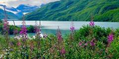
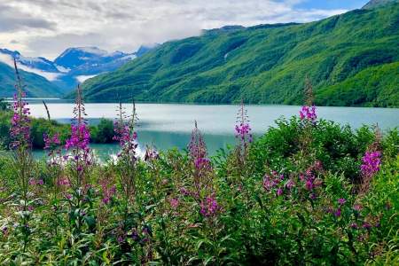
The Pilgrim River crossing brings you close to groves of cottonwood that are abundant in this section of the valley. Look for spawning salmon, moose, and a variety of birds.
Beyond the Pilgrim River Bridge, the road continues uphill and offers sweeping views of a network of lakes and the meandering river valley. North of the Pilgrim River drainage is a large hill topped with a series of granite rock outcroppings known as Hen and Chickens because of its resemblance to a small flock at certain angles. A cross was placed at the summit in memory of a priest who died in a blizzard on his way to the orphanage.
The northernmost lake is called Swan Lake but several lakes in this area may hold a wide variety of birds. Tundra swan with cygnets, Canada goose, sandhill crane, northern shoveler, black scoter, long-tailed duck, greater and lesser scaup, and canvasback frequent the ponds. Red-necked grebe build floating nest platforms. The perimeter of meadow habitat with threads of water drainages are good places to find Pacific golden-plover. Look for signs ...more
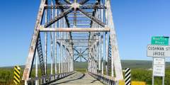
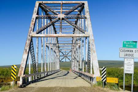
The Kuzitrin River Bridge had its origins in Fairbanks. It was originally named the Cushman Street Bridge when it was built across the Chena River in the heart of downtown Fairbanks in 1917. In the 1950s the bridge was replaced with a concrete span and the original metal bridge was disassembled, shipped down the Chena, Tanana, and Yukon rivers and barged up the Bering Sea coast to Nome. It was hauled in sections up the Nome-Taylor Highway and ...more
Several small lakes and ponds sprinkle the landscape on either side of the road. Look for a small hillock just beyond the first lake. This lone pingo rises above the surrounding flat tundra meadow and serves as a convenient lookout for hunters such as foxes, wolves, hawks, owls, and jaegers. The soil on the tops of pingos is fertilized by predator feces and prey remains and generally supports lush and diverse vegetation.
Though built to accommodate the road from Bunker Hill to Taylor in the early 1900s, the bridge is as far as you can go by highway vehicle. From here a rough, unmarked, and sometimes impassable ATV trail leads to Taylor where family-owned mines still operate. Look for canada goose and white- fronted goose. Bluethroat can be found on shrubby river banks. Arctic grayling are the most likely fish to be seen from the bridge.
Descending into terrain increasingly dominated by trees and willows, you are more likely to see a moose than a muskox. In late summer grizzlies feed on spawning chum salmon below the Fox River bridge. Salmon carcasses also attract red fox, gulls, and common ravens. Both abandoned and active beaver lodges and dams are found along the Fox River drainage. Dolly Varden, Arctic grayling, and chum and pink salmon can be seen from the bridge. ...more
An old road bed leading to a Solomon River overlook is a good spot to look for salmon, Dolly Varden, and Arctic grayling in late July and August. Say’s phoebe will launch from its nest to catch insects. Northern shrike, harlequin duck, spotted sandpiper, and wandering tattler are also seen. In some years, the cliff is occupied by common raven, rough-legged hawk, or other raptors so be careful your presence does not disturb nesting birds.
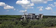
Lee’s Dredge, the last dredge to work the Solomon River, was operated by the Lee family until the 1960s. It now provides nesting platforms for raptors and ravens. You may see green-winged teal and phalaropes feeding in the dredge pond and songbirds in the surrounding willows.
Shovel Creek passes under the road through a double culvert before it enters the Solomon River. A year-round spring that feeds the creek near the road keeps the water from freezing in winter. This attracts dippers, beaver, mink, and otter and encourages the growth of cottonwoods. The spring-fed creek also offers a moderate amount of spawning habitat for pink, chum, and coho salmon in late July and August. Dolly Varden are present but few Arctic ...more
Golden Gate Pass divides the gold-laden creeks and rivers to the south from Pilgrim and Kuzitrin Rivers. This pass is a migration corridor into the Pilgrim River drainage for the Western Arctic caribou herd in years when they winter on the central Seward Peninsula. American golden-plover, northern wheatear, American pipit, and Lapland longspur are common in the tundra areas.
River crossing warning! Unlike other braided rivers along the road system, the Niukluk River flows along a single broad channel. A large colony of cliff swallow inhabits the cliff banks downstream while tree swallow nest in aspen cavities and nest boxes put up by Council residents. Osprey, which nest down- stream, may be spotted flying over the river. Bald eagle are also associated with the river and nest at the Fish River confluence. ...more
Nome-Council Highway
These stops on the east edge of Nome (described in more detail in the Council Road section) offer freshwater ponds adjacent to the marine water coastline that attract a wide variety of spring migrant waterbirds and shorebirds as the ice is melting in late May and early June. The area is worth checking regularly because arriving species often make a short stop before moving inland. By mid-summer, early departing shorebirds gather to feed and ...more
The bridge marks a mixing zone where fresh river water meets tidal salt water and turns brackish. This creates a blend of water types and habitats and attracts many different birds to areas of open water or the mud-bar edges of islands. Look for geese, cranes, shorebirds, and gulls in good numbers, even unusual species like Arctic loon, red knot, black-tailed godwit, red-necked stint, ivory gull, and white wagtail. Also spot spawning salmon. ...more
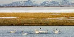
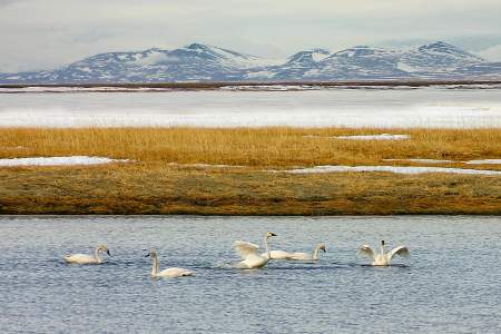
Safety Lagoon slowly narrows and mixes with wetlands, ponds, and the Bonanza River estuary. Thousands of tundra swan move through this area on their spring migration. Breeding swans move on to upland ponds to nest and raise their young, while non-breeding birds may remain all summer. In the fall, parts of the lagoon and Solomon River wetlands turn white with huge groups of swans preparing for fall migration.
In the fall, people fish for tomcod from the bridge. Deep diving ducks feed in the channel depths of the Bonanza River. Sandhill crane feed on berries, plant shoots, roots, insects, and even small rodents. Red-throated loon and, less commonly, Pacific loon float the waters.
Approaching the East Fork of Solomon River, a wide pull-off on the left is an excellent place to park and scan the slopes and river valley for wildlife. Northern wheatear and American pipit frequent the rocky slopes nearby. Cliff swallow often build nests on the bridge supports, and ravens and raptors occasionally nest in the area. This view of the river makes it easy to find red-breasted merganser, harlequin duck, tattlers, and gulls.
The rocky outcrop across the Solomon River usually hosts an active golden eagle nest. Look for a huge tower of sticks and splashes of whitewash and orange lichen in the vicinity of the nest and surrounding perching sites. Built by eagles and added onto in successive years, the nest i s distinctive for its large size, construction, and shape. When not occupied by eagles, the large nest may be used by gyrfalcons.
Leaving Cape Nome, the road passes through the coastal grasslands, dunes, and meadows of a long and narrow barrier island environment. This sandy strip of land divides the protected wetlands and lagoon of Safety Sound from the unprotected marine waters of Norton Sound and the Bering Sea. The close proximity of these waters makes this one of the most dynamic and interesting places for birdlife on the road system.
Cape Nome is a massive granitic outcrop that is much more resistant to weathering than surrounding lands. Local Alaska Native corporations quarry the rock, which is trucked or barged to large-scale construction projects up and down the coast. Nome’s seawall is built from this granite. Amidst considerable construction or quarry activity, birds continue to nest or roost on the rock faces. The thickly-vegetated slopes attract dense numbers of ...more
The crossing offers expansive views of a variety of creekside habitats, each with its own distinctive characteristics. In spring the upstream portion of the creek is filled with thick layers of glaciered ice that build up from winter’s continual freezing of the spring waters that flow year-round into the creek. This late flow of melt water attracts waterbird species long after other areas are ice-free. Driftwood collects in the deeper pools ...more
The road junction is marked by ponds and tundra meadows within sight of the coastal beachline. Loons, red-breasted merganser, long-tailed duck, scoters, gulls, and Arctic tern are common on the marine water and sometimes venture inland to ponds or tundra tussocks. Less frequently, Aleutian tern and long-tailed jaeger may be interspersed among perched glaucous and mew gulls near the road.
Nome - Teller Highway
“Nomehenge,” as some of the locals call the four towering antennas on Anvil Mountain above Nome, operated during the height of the Cold War to link remote parts of Alaska with the rest of the country. These are the last of 71 White Alice structures, and serve as important historic and geographic landmarks in Nome.
Glacier Creek Road runs approximately 30 miles up the east side of the Snake River. It becomes a rough four-wheel-drive road after it passes the Rock Creek Mine site three miles in and is not maintained in winter. If you look north up the valley from Teller Road, you will see the pyramid-shaped peak of Mount Osborn, the tallest peak on the Seward Peninsula. Look for birds nesting in the small lakes on either side of the road.
The Snake River has a relatively short drainage that flows out of the south side of the Kigluaik Mountains. Prime moose, birding, and salmon viewing habitat.
Seven miles off the coast, Sledge Island is visible on clear days from this section of Teller Road. Originally named Ayak, the island was home to about 50 Ayakmiut, who primarily hunted seals but also walrus when those animals migrated close to shore.
The bridge crossing gives a good view of birdlife, spawning salmon, and moose. Red-breasted merganser and harlequin duck like the swift-flowing water.
Driving north, the rocky outcrop on your right may host a nesting or perching site for rough-legged hawk, gyrfalcon, and common raven. Look to your left into the creek bottom to see an active beaver lodge with several dams and ponds.
House Rock and Cabin Rock are local names for the obvious rock formation on the right. Look for Arctic ground squirrel on the dry, upper slopes and for Musk ox on the windblown summits. This is also a great birding area.
The steep road grade on either side of Cripple River gives a good overview of the thin thread-like river that runs through the valley. Gold mining activities occurred in the upper tributaries, as evidenced by the road and horizontal ditch lines. Look for harlequin ducks paddling swift river currents in late August or September, and Pink Salmon swimming upstream to spawn.
This 100-foot-wide road is a public right-of-way that traverses lands privately owned by the King Island Native Corporation. It runs eight miles to traditional summer fishing camps at Woolley Lagoon. Please stay within 50 feet of either side of the road. Do not photograph or travel close to lagoon or camps. A pull-off to the right offers views of Moon Mountains, a wintering spot for muskox. Also watch for red fox and black-bellied plovers. ...more
As you approach the Tisuk River, scan downstream and across the river for a large nest of sticks on an orange lichen-covered rock outcrop. Built by golden eagles, it may be used by gyrfalcon when not occupied by eagles.
The road parallels a somewhat narrow creek valley, making it easy to see water and shorebirds associated with flowing water as well as the wide variety of songbirds, such as thrushes, warblers, and sparrows that hang out in dense shrubs clustered at creek’s edge. Arctic grayling, and sometimes pink salmon, are found here.
The Bluestone River is unlike other river crossings along the Teller Road because it flows northward to Imuruk Basin rather than south to Norton Sound. The river is deeply incised as it cuts through steep mountains, creating steep, rocky slopes and cliffs. Rough-legged hawk, golden eagle, gyrfalcon, and common raven may nest on nearby rock cliffs
At Teller the road returns to sea-level where the environment is dominated by marine waters. Look for spotted seals on calm days, their heads popping up inquisitively at the tip of the spit. Pelagic cormorant, pigeon guillemot, horned puffin, common eider, and black scoters are seen here.
The Sinuk River is the largest river crossing on the Teller Road, and the magnitude of the valley, river channels, craggy mountains, and rolling tundra — all in one panoramic vista — is an impressive sight. The bridge is a reliable spot to see salmon on their return upriver. Birdlife tends to be those species attracted to flowing water and gravel bars, islands, and thick vegetation clustered in some sections of the river.
About a mile further north on Center Creek Road, a wetland meadow lies west of the old Nome dump, which is now used as a monofil area for large bulky refuse that does not belong in the sanitary landfill. The monofil area might attract ravens or gulls, but the real gem is the wetland meadow interspersed with remnant structures from earlier mining activity. Rednecked phalarope, pintail, teal, and scaup are often floating on the pond near the road, ...more