Ketchikan Parks & Trails
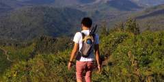
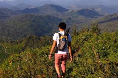
Ketchikan is a busy fishing and tourism port, especially during the height of the summer season. This is also a beautiful time to explore area hiking trails, where you can admire the variety of local flora, find inspiring views of mountains and the ocean, and challenge yourself with vertical climbs above tree-line. Local hiking guide Teague Whalen wrote this introduction to hiking in Ketchikan. It gives you an overview of what to expect on the trails – the weather, the plants, the cell-phone coverage – and links to additional resources you can consult before your visit. If you decide to explore the area on a guided hike, Teague offers Mindfulness Rainforest Treks.
Navigating the Trails of Ketchikan
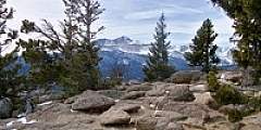
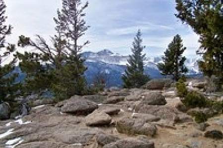
There’s really only one forty-mile road that stretches along the edge of Revillagigedo Island, so all the trails on the road system are usually just minutes away. Most are well-marked and easy to follow, though the trails that climb into the alpine and higher elevations may be covered in snow from mid-October to mid-May. Mountains hover around 3000-feet tall, often with a base starting right at or near sea-level, so that’s an entire 3000 feet of vertical from base to peak. At some of the higher elevations, such as hiking up toward
Minerva Mountain from Carlanna Lake, you have to keep an eye out for the cairns to direct your path because there are no tall trees upon which to place markers, only a steep, vegetation-spotted rock slope. Even though the mountains are on the small side, there are tree-lines on some of the mountains because of the northern latitude and extreme climate. Once you are in alpine country, you may be above tree-line and will only have the path below your feet to follow. Often, the direction to go can be pretty clear once you are up on the mountain ridges and tops because there are very limited choices of where to go due to precipice drop-offs. On clear sunny days, orienting visually is easy if you have a sense of north, west, east, and south and are familiar with landmarks around you (mountains, ocean). It’s highly recommended to bring a GPS and map, in case the high country is socked in with clouds, rain, or snow. In these conditions, navigating can become extremely difficult and sometimes dangerous. For the most part, if there is a distinct trail under your feet, there shouldn’t be anything to worry about. You can get more detailed trail information in the National Forest Service’s Ketchikan Area Trails Guide.
Plant life on Revillagigedo Island: Step foot on the trails and enter a dense rainforest canopy of Sitka spruce, western red cedar, hemlock, and alders, and a trail brushed with devil’s club, skunk cabbage, ferns, and a plethora of berry bushes—salmonberries, blueberries, huckleberries, and thimbleberries, to name a few. Many species of mushroom and moss grow abundantly here as well. Hiking further into the higher elevations on the mountain trails, you may find yourself walking through much more open muskeg meadows, with thinner and smaller mountain hemlock, yellow cedar, and the tough, knee-sized krummholz. A favorite resource for identifying the flora in Southeast Alaska is Plants of the Pacific Northwest Coast by Jim Pojar and Andy MacKinnon. You can find additional guides, brochures and maps at the U.S. Forest Service Discovery Center, a block over from the cruise ship berths. You may also want research edible berries and mushrooms. The U.S. Forest Service offers information on Alaskan poisonous plants and information on mushrooms. A good rule of thumb: if you don’t know what it is for sure, don’t eat it.
Challenging Hikes
Two mountain traverses offer more challenging hiking for people who are in great shape, are very good at sniffing out a faint alpine trail, know how to read the weather, and are proficient with using topographical maps with a compass or GPS. The Deer Mountain to Silvis Lakes traverse is a fourteen-mile, one-way trek across some remote alpine country and climbs over Deer Mountain and Northbird Peak, skirts just below John Mountain and Mahoney Mountain, and ends up at the south end of the Tongass Highway. The Carlanna Lake to Perseverance Lake traverse is roughly ten miles, one way, and climbs over Juno and Ward Mountains. These traverses can be done in a day, or you can camp along the way if you want to carry in equipment. Note: Do not underestimate the rigors of a traverse that crosses multiple mountains. Several people have gotten into trouble on these traverses, especially the more popular Deer Mountain to Silvis Lake traverse.
Cell-Phone Coverage
Cell-phone coverage can be very spotty. They can generally be used on Deer Mountain, Ward Lake, Ward Creek, Rainbird, Carlanna, and Coast Guard Beach trails. There is no service at both ends of the Tongass Highway, which affects The Silvis Lakes Trail and Mahoney Mountain in the south and Lunch Creek Trail at the north end. Also, there is no cell service driving up Brown Mountain Road, off of Revilla Road, which takes you to Dude Mountain trailhead. As a result, the Dude Mountain trail does not have cell service either, except sometimes at the top of the mountain. Perseverance Trail offers spotty cell service. If you are in a dead zone, it is often helpful to power down your phone so power isn’t drained from trying to continually search for service. Then you can still use it for photos, time-checks, or emergencies. Do remember to enjoy the Alaskan wilderness around you, which is typically more inspiring than emails or Facebook!
Transportation
You can walk to some of the trails and take a city bus to others. Further out, you’ll need a car. Walking: Deer Mountain and Rainbird Trail trailheads are each about a 1.5 miles from downtown Ketchikan. Carlanna Lake Trail is about a three-mile walk from downtown, or a bus or taxi could drop you off at Carlanna Lake Road. Bus: You could also take the bus 7.5 miles north to Ward Lake Road and hike up to Frog Pond Trail, which leads down to Ward Lake Trail. This can connect you to the Perseverance and Ward Creek Trails and some others in the vicinity. The bus occasionally runs fifteen miles north to Clover Pass Church, where you could hike a mile down North Point Higgins Road to access the North Point Higgins Trail to Coast Guard Beach. You’ll need a car or taxi for the trails not easily accessible by bus. For any hiking that can’t be reached from Ketchikan’s road system, several float-plane businesses are available for hire. Baranof Excursions, a popular local charter fishing company, can transport people by boat to remote cabins and trails in the surrounding area. Be aware that sometimes aviation and marine transportation are canceled due to unnavigable weather.
Ketchikan Weather
Most people visit in the summers–roughly May through September–which have been very sunny and pleasant in recent years. Expect high 50s to 60s and sometimes 70s when the sun is out. When the sun is behind cloud cover, expect cool and wet weather in the 40s and 50s. For the most part, summer weather and longer days can be quite forgiving for visitors, except for the occasional nasty weather day. You will want to be prepared with some raingear and warmer layers. The weather usually can be colder and windier at the top of mountains, sometimes even raining, when you may have started hiking at a warmer and clearer forecast at sea level. Read Teague’s guide to the weather in Ketchikan if you plan on visiting outside of the summer season or you are curious to learn more about the specific weather patterns.
Teague Whalen’s Top Ten Best Ways To Avoid A Bad Ending
- Hike with a partner and tell someone where you are going
- Carry a spot locator
- Bring hard copies of maps and a compass
- Stay on the trail
- Pay attention to the changing weather
- Have a turn-around time
- Listen to the slowest member
- Trust your gut and voice your concerns
- Stay with the group (if you can)
- Leave no trace
Show Map
Ketchikan Hiking Trails
Deer Mountain is Ketchikan’s iconic backdrop. The path briefly threads between residential lots, then turns to a rocky trail that quickly ascends. On the way up there are multiple scenic overlooks.

The one-mile gravel trail to Coast Guard Beach winds through Ketchikan Gateway Borough land and then crosses into Alaska Mental Health Trust Land. Mostly the trail descends to the beach; however, a few hills do rise along the way. This beach is a good place for walking, sunbathing, beachcombing, photography, writing, reading, meditation, tai-chi, just sitting, marine-life viewing, and dog swimming.
Connell Lake is a good choice if you want a trail that is less popular but just as close to town as the Perseverance trail. The rocky, dirt path gently climbs through the rainforest canopy and hugs the shoreline of the lake. On the other side is a nice flat area that the creek bows around, creating a small peninsula. A fire-pit indicates that this is a preferred spot to spend some time or camp.
The Salvage Trail is an out-and-back trail that rolls up and down through the woods, paralleling Revilla Road. The trail is a wide gravel path where two-to-three people can walk beside each other.
This hike offers a nice wide-open space experience and is not very long. Much like hiking the access road to Lower Silvis Lake, the Whitman Trail is another service road to two dams that generate electricity for Ketchikan residents and was recently made available for hiking and recreation; however, no motorized vehicles are permitted. Informative signs are posted on a fence gate up the road and on both dams.
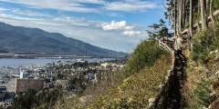
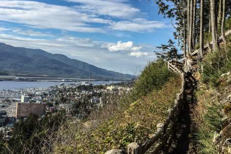
Running just above and parallel to Ketchikan’s Third Avenue Bypass, Rainbird Trail is perfect if you only have a couple hours but still want to experience a small piece of Southeast Alaska’s rainforest. The trailhead is only 20 minutes from downtown (a short drive relative to most other trails), and the trail’s southern end — just beyond the top of the metal stairs — offers great views of downtown Ketchikan, the Tongass Narrows, and the neighboring ...more
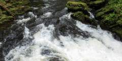
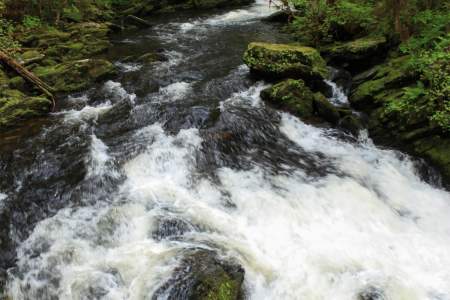
On one of the run-off creeks from Achilles Mountain or Twin Peaks Mountain above pours a 100-foot or more waterfall right beside Tongass Highway towards the end of the road
Leaving from the end of Tongass Highway, enter the Lunch Creek Trail and very soon take the trail to the left as this steps you quickly down to a waterfall viewing platform and then the rest of the way down to where, to the right, you can also cross the Lunch Creek bridge, which provides waterfall views as well as the ocean where the creek flows into.
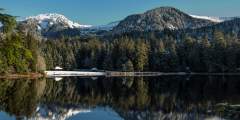
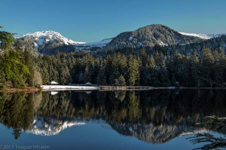
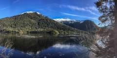
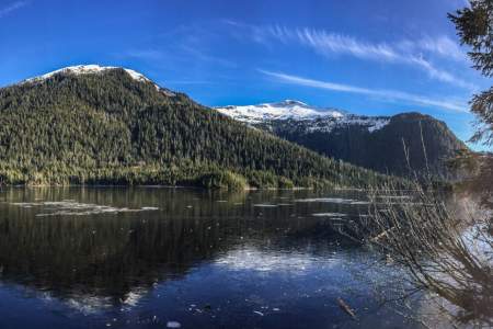
The mostly-flat Ward Lake trail follows the circumference of the lake’s shore in a swath of gravel that is wide enough for two people to walk abreast. Ward Lake is tucked into the edge of the Tongass National Forest boundary. Its proximity to town makes the recreation area popular with the locals.
Located in the Tongass National Forest, Ward Creek is wide enough to drive a truck down, though no vehicles are permitted, and is popular with the locals for walking dogs. Across the road from the Ward Lake Recreation Area parking lot, trailhead 1 takes you north and follows Ward Creek, which flows out of Connell Lake, by the Last Chance campground, and through Ward Lake to eventually meet the ocean in Ward Cove.
If you are a lover of alpine, stunning views, and longer, more challenging hikes, then this all-day, one-way mountain traverse between Carlanna Lake and Perseverance Lake is the perfect choice.
If you are looking for a shortish “in-town” trail, this trail begins at the back of a neighborhood and walks up a service road to a dam that overlooks a mountain-lake scene.
This is a popular weekend hike if you want to spend two-to-four hours in the Tongass National Forest and is only about 15 – 20 minutes north of town. Though you gain elevation on the hike up to the lake, it is not unforgivingly steep. Perseverance Lake is one of Ketchikan’s picturesque mountain-lake scenes.
If you want to get away and don’t have a boat or a plane, this is as far away north one can easily get from Ketchikan. The trail ends at the headwaters of Lunch Creek — the shores of Lake Emery Tobin, which is surrounded by a rim of steep mountainsides often capped with snow ridges and peaks.
The drive out to the Dude Mountain trailhead is one of the most scenic drives that Ketchikan has to offer. The trail begins winding through lush rainforest. The last part is steep and can be muddy in wet weather or covered in snow in spring and fall.
Refuge Cove State Recreation Site is a sliver of land lining part of an edge of a neighborhood and is a popular beach picnicking destination with the locals. The site comes complete with pit toilets, sheltered and unsheltered picnic tables with fire grates, and a quarter-mile trail accompanied by interpretive signs that address the local natural history.
Settlers Cove State Recreation Site, at Mile 18 of North Tongass Highway near Ketchikan, offers 13 wooded campsites along Clover Passage. Surrounded by spruce and hemlock, it features two sandy beaches, vault toilets, picnic shelters, and a trail to a waterfall. Campers can swim, paddle, beachcomb, or take in coastal views, with Ketchikan’s attractions just a short drive away.
Hear shrieks and squeals of excitement as kids wade around in tidepools with their buckets finding all manner of critters – eels, bullheads, snails, hermit crabs, sea urchins, sea anemones, starfish, blimmies (eeltype fish), small octopus, eelgrass, clams, mollusks, and kelps.