Alaska Backcountry Trip Selection Matrix
By Haley Johnston
Wilderness Guide, writer, backcountry enthusiast
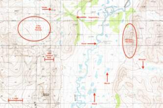
This Trip Selection Matrix includes twelve trips in the Alaskan backcountry. This is by no means a comprehensive list of the trips available in Alaska - you could adventure here for a lifetime and barely scratch the surface. These trips are not necessarily the twelve best trips in Alaska, that is certainly a subjective distinction. But these trips do offer a geographic cross-section of the state, so if you want to adventure anywhere from southeast Alaska to the arctic, there is a trip here for you. There is also a range of trip lengths from 2 days to over a week and from the inexpensive to the pricey. And, there are trips outlined here suitable for a first timer and experienced backcountry adventurers. So whether it is your first trip to Alaska, and you are looking for an overnight in southcentral Alaska, or you are a longtime Alaskan resident looking to expand your skillset with a weeklong trip to the Brooks Range, there is an option here for you. Happy Adventuring!
JUMP TO TRIP: 20 Mile Packtraft | Arrigetch Peaks Basecamp | Chena Dome Backpack | Chilkoot Trail Backpack | Crow Pass Backpack (Packraft Option) | Guilbeau Pass Backpack (Packraft Option) | Kesugi Ridge Backpack | Mint Valley Backpack | Oolah Pass Backpack | Resurrection Pass Backpack | Sanctuary River Packraft | Twin Lakes Packraft | Valley of 10,000 Smokes Backpack | Key
20 Mile Packraft
| Why choose this trip? | The Winner Creek to 20 Mile River loop is a great first packrafting trip. For those with packrafting skills, this route offers a quick, easy-to-access, multi-sport adventure. The hike up to Berry Pass is seriously underrated and the views of the 20 Mile watershed are not to be missed. |
| Trip Type | Packraft |
| Region | Southcentral |
| Distance(s) | 11 miles hiking; 15 miles packrafting |
| # Days | 2 |
| Backcountry Starting Point | Winner Creek Trailhead at Alyeska Resort (Girdwood, AK) |
| Backcountry Ending Point | 20 Mile River Bridge on the Seward Highway |
| Logistics | Moderate |
| Experience Level Required | Novice backpacker, Beginner packrafter |
| Hazards of Note | Wood hazards in upper 20 mile, tide, bear country, stream crossings |
| Will you see other parties on this trip? | Probably |
| Land Manager | Chugach National Forest; Glacier Ranger District |
| GPS Coordinates | Starting Point - Winner Creek Trailhead: 60.97003, -149.09692 Berry Pass: 60.97678, -148.95175 Ending Point - 20 miles river bridge: 60.84454, -148.98732 |
| USGS Maps | Seward D-6 Seward D-5 |
| Cost | $ |
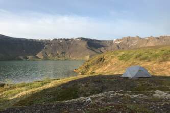
Arrigetch Peaks Basecamp
| Why Choose This Trip? | Camp beneath the iconic Arrigetch Peaks - a great destination for backpackers and hardcore climbers alike. |
| Trip Type | Backpacking |
| Region | Northern |
| Distance(s) | 24+ (13 miles each way from drop-off/pick-up location to the Arrigetch Peaks) |
| # Days | 6+ |
| Backcountry Starting Point | Circle Lake |
| Backcountry Ending Point | Circle Lake |
| Logistics | Complex |
| Experience Level Required | Intermediate Backpacker |
| Hazards of Note | Stream and river crossings; bear country |
| Will you see other parties on this trip? | Possibly |
| Land Manager | Gates of the Arctic National Park |
| GPS Coordinates | Starting/Ending Point - Circle Lake: 67.48528, -153.87398 |
| USGS Maps | Survey Pass B-2 Survey Pass B-3 |
| Cost | $$$$ |
Chena Dome Backpack
| Why Choose This Trip? | One of the best trips near Fairbanks with incredible views, excellent walking and easy logistics. |
| Trip Type | Backpacking |
| Region | Central |
| Distance(s) | 29 miles |
| # Days | 2-4 |
| Backcountry Starting Point | 50.5 Miles down the Chena Hotsprings Road (NE of Fairbanks) |
| Backcountry Ending Point | 49.4 miles down the Chena Hotsprings Road (NE of Fairbanks) |
| Logistics | Simple |
| Experience Level Required | Beginner Backpacker |
| Hazards of Note | Scarce water; weather; bear country |
| Will you see other parties on this trip? | Probably |
Land Manager | Chena River State Recreation Area |
| GPS Coordinates | Starting Point - Upper Chena Hotsprings Road Trailhead: 65.03514, -146.21500 Chena Dome (highpoint): 65.08318, -146.46738 Trail Shelter: 65.013750, -146.555167 Ending Point - Lower Chena Hotsprings Road Trailhead: 65.01371, -146.22322 |
| USGS Maps | Circle A-5 Circle A-6 |
| Cost | $ |
Chilkoot Trail Backpack
| Why Choose This Trip? | An amazing look at the history of the Alaskan Gold Rush with the added novelty of hiking from Alaska to Canada - two countries, one trip! |
| Trip Type | Backpacking |
| Region | Southeast |
| Distance(s) | 33 miles |
| # Days | 2-4 |
| Backcountry Starting Point | Dyea (outside of Skagway, AK) |
| Backcountry Ending Point | Bennet, BC, Canada |
| Logistics | Complex |
| Experience Level Required | Novice Backpacker |
| Hazards of Note | Bear country |
| Will you see other parties on this trip? | Definitely |
| Land Manager | Klondike Gold Rush National Historical Park |
| GPS Coordinates | Starting Point - Chilkoot Trailhead: 59.51185, -135.34663; Chilkoot Pass: 59.69654, -135.23828; Ending Point - Bennett, BC: 59.84527, -134.99562 |
| USGS Maps | Skagway C-1 |
| Cost | $$$ |
Crow Pass Backpack (Packraft Option)
| Why Choose This Trip? | A Chugach Classic with big glacier views, this trail is widely considered one of the best in Alaska! |
| Trip Type | Backpack or Packraft |
| Region | Southcentral |
| Distance(s) | 23 miles |
| # Days | 2-3 |
| Backcountry Starting Point | Crow Creek Trailhead (Girdwood, AK) |
| Backcountry Ending Point | Eagle River Nature Center |
| Logistics | Simple to Moderate (depending on shuttle) |
| Experience Level Required | Novice backpacker, Beginner packrafter |
| Hazards of Note | Stream and river crossings; bear country |
| Will you see other parties on this trip? | Probably |
| Land Manager | Chugach National Forest and Chugach State Park |
| GPS Coordinates | Starting Point - Crow Creek Trailhead: 61.02825, -149.11602 Crow Pass: 61.06076, -149.11645 Ending Point - Eagle River Nature Center: 61.23390, -149.27075 |
| USGS Maps | Anchorage A-7, Anchorage A-6 |
| Cost | $-$$ |
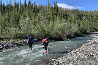
Guilbeau Pass Backpack (Packraft Option)
| Why Choose This Trip? | Follow the footsteps of the Porcupine Caribou Herd and test your off-trail travel skills in some of Alaska's best hiking terrain. |
| Trip Type | Backpacking |
| Region | Northern |
| Distance(s) | |
| # Days | 6+ |
| Backcountry Starting Point | Airstrip on the Hulahula River (local name: Grasser's Strip) |
| Backcountry Ending Point | Airstrip on the upper Chandalar |
| Logistics | Complex |
| Experience Level Required | Intermediate Backpacker |
| Hazards of Note | Stream and river crossings; bear country |
| Will you see other parties on this trip? | Unlikely |
| Land Manager | Arctic National Wildlife Refuge |
| GPS Coordinates | |
| USGS Maps | Mt. Michelson A-2 Mt. Michelson A-1 Arctic D-1 |
| Cost | $$$$ |
Kesugi Ridge Backpack
| Why Choose This Trip? | Unparalled views of Denali (formerly Mt. McKinley) |
| Trip Type | Backpacking |
| Region | Central |
| Distance(s) | 17.8 to 37 miles |
| # Days | 2-4 |
| Backcountry Starting Point | Little Coal Creek Trailhead (other options detailed on Trip Page) |
| Backcountry Ending Point | Upper Troublesome Creek Trailhead (other options detailed on Trip Page) |
| Logistics | Moderate |
| Experience Level Required | Beginner Backpacker |
| Hazards of Note | Weather - exposed on the ridgeline; bear country |
Will you see other parties on this trip? | Probably |
| Land Manager | Denali State Park |
| GPS Coordinates | Starting Point - Little Coal Creek Trailhead: 62.89223, -149.74754 Ermine Hill-K’esugi Ridge Trail Junction: 62.79459, -149.86834 Ermine Hill Trailhead: 62.82752, -149.90431 Ending Point - Byers Lake Campground: 62.74535, -150.11820 Troublesome Creek Trailhead: 62.63013, -150.22572 |
| USGS Maps | Talkeetna Mountains D-6, Talkeetna Mountains C-6 |
| Cost | $-$$ |
Mint Valley Backpack
| Why Choose This Trip? | A straightforward trip with big scenery payoffs - the picturesque Mint Hut and a valley dotted with hanging glaciers! |
| Trip Type | Backpacking |
| Region | Southcentral |
| Distance(s) | 16 miles (out-and-back up Mint Valley); additional options detailed on trip page |
| # Days | 2-4 |
| Backcountry Starting Point | Gold Mint Trailhead in Hatcher Pass |
| Backcountry Ending Point | Gold Mint Trailhead in Hatcher Pass |
| Logistics | Simple |
| Experience Level Required | Novice Backpacker |
| Hazards of Note | Bear Country |
| Will you see other parties on this trip? | Probably |
| Land Manager | State of Alaska, Department of National Resources |
| GPS Coordinates | Starting/Ending Point - Gold Mint Trailhead: 61.77799, -149.19880; Mint Hut: 61.856767, -149.079767 |
| USGS Maps | Anchorage D-6 |
| Cost | $ |
Oolah Pass Backpack
| Why Choose This Trip? | Find out why the Brooks Range is known to have the best off-trail hiking in Alaska! |
| Trip Type | Backpacking |
| Region | Northern |
| Distance(s) | 65 miles (Anaktuvuk Pass to Dalton Highway); shorter options detailed on trip page |
| # Days | 6+ |
| Backcountry Starting Point | Anaktuvuk Pass or Summit Lake Air Strip |
| Backcountry Ending Point | Dalton Highway |
| Logistics | Complex |
| Experience Level Required | Intermediate Backpacker |
| Hazards of Note | Stream and river crossings; bear country |
| Will you see other parties on this trip? | Unlikely |
| Land Manager | Gates of the Arctic National Park |
| GPS Coordinates | Starting Point - Anaktuvuk Pass: 68.13796, -151.73479 Ernie Pass: 68.08867, -150.94199 Peregrine Pass: 68.07424, -150.69309 Summit Lake: 68.07210, -150.47226 Oolah Pass: 68.06669, -150.00232 End Point - Dalton Highway: 68.02557, -149.70706 |
| USGS Maps | Chandler Lake A-3, Chandler Lake A-2, Chandler Lake A-1, Philip Smith Mountains A-5 |
| Cost | $$-$$$$ |
Resurrection Pass Backpack
| Why Choose This Trip? | All the joy of backpacking, with the optional comfort of staying in cabins if you make reservations in one or more of the cabins along the trail. |
| Trip Type | Backpacking |
| Region | Southcentral |
| Distance(s) | 38 miles (Hope to Cooper Landing) |
| # Days | 3-5 |
| Backcountry Starting Point | Resurrection Pass Trailhead North (Hope, AK) |
| Backcountry Ending Point | Resurrection Pass Trailhead South (Cooper Landing, AK) |
| Logistics | Moderate |
| Experience Level Required | Novice Backpacker |
| Hazards of Note | Bear Country |
| Will you see other parties on this trip? | Definitely |
| Land Manager | Chugach National Forest; Seward Ranger District |
| GPS Coordinates | Starting Point - Resurrection Pass Trailhead North: 60.86873, -149.63045 Caribou Creek Cabin: 60.78314, -149.67751 Fox Creek Cabin: 60.73109, -149.70988 East Creek Cabin: 60.70490, -149.74849 Resurrection Pass (and Summit Creek Trail junction): 60.64055, -149.72265 Devil’s Pass Cabin (and Devil’s Pass Trail junction): 60.62071, -149.75413 Swan Lake Cabin: 60.61248, -149.84008 Juneau Lake Cabin: 60.57525, -149.87179 Ending Point - Resurrection Pass Trailhead South: 60.48376, -149.9531 |
| USGS Maps | Seward B-8 Seward C-8 Seward D-8 |
| Cost | $-$$ |
Sanctuary River Packraft
| Why Choose This Trip? | Experience the backcountry of Denali National Park in a way few others do! |
| Trip Type | Packraft |
| Region | Central |
| Distance(s) | 13 miles hiking; 17 miles packrafting |
| # Days | 2-3 |
| Backcountry Starting Point | Denali Park Road just east of Sable Pass |
| Backcountry Ending Point | Denali Park Road at the Sanctuary River Campground |
| Logistics | Moderate |
| Experience Level Required | Intermediate Backpacker, Beginner Packrafter |
| Hazards of Note | Stream and river crossings; bear country |
| Will you see other parties on this trip? | Unlikely |
| Land Manager | Denali National Park |
GPS Coordinates | Starting Point - Near Sable Pass: 63.55685, -149.64624 Calico Creek Pass: 63.52482, -149.39790 Ending Point - Sanctuary River Campground: 63.71948, -149.47620 |
| USGS Maps | Healy C-6, Healy C-5 |
| Cost | $$ |
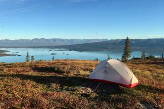
Twin Lakes Packraft
| Why Choose This Trip? | A combination of classic Alaskana - float planes, big mountains, crytal blue lakes and homesteading history! |
| Trip Type | Packraft |
| Region | Southwest |
| Distance(s) | Distances vary, detailed on trip page |
| # Days | 3-5 |
| Backcountry Starting Point | Upper Twin Lakes |
| Backcountry Ending Point | Lower Twin Lakes (coordinate a pick-up location with your air taxi) |
| Logistics | Complex |
| Experience Level Required | Novice Packrafter |
| Hazards of Note | High winds can create wave hazards on the lakes; bear country |
| Will you see other parties on this trip? | Possibly |
| Land Manager | Lake Clark National Park |
| GPS Coordinates | Proenneke Cabin Coordinates: 60.648511, -153.81311 Hope Creek Campground coordinates: 60.64259, -153.82084 Emerson Creek Trailhead Coordinates: 60.63227, -153.90394 |
| USGS Maps | Lake Clark C-3, Lake Clark C-2 |
| Cost | $$$$ |
Valley of 10,000 Smokes Backpack
| Why Choose This Trip? | Experience a landscape literally like no other - a desert-like moonscape ringed by glaciated volcanoes! |
| Trip Type | Backpacking |
| Region | Southwest |
| Distance(s) | 25-40 miles |
| # Days | 4+ |
| Backcountry Starting Point | Three Forks Visitor Center |
| Backcountry Ending Point | Three Forks Visitor Center |
| Logistics | Complex |
| Experience Level Required | Intermediate Backpacker |
| Hazards of Note | River crossings, severe wind, scarce water |
| Will you see other parties on this trip? | Unlikely |
| Land Manager | Katmai National Park |
| GPS Coordinates | Starting/Ending Point - Three Forks Visitor Center - 58.368734, -155.383066 Possible Campsite on Windy Creek: 58.355576, -155.382723 West Mageik Lake: 58.238827, -155.282991 East Mageik Lake: 58.238827, -155.239733 |
| USGS Maps | Katmai A-4, Katmai B-5, Katmai B-4 |
| Cost | $$$-$$$$ |
Key
| Data Type | Potential Choices | Description | Examples |
|---|---|---|---|
Trip Types | Backpacking | Hiking that requires at least one night in the backcountry. Skills required: tent camping, camp cooking, moderate to advanced routefinding and navigation, (possibly) stream and river crossing technique, Leave No Trace, traveling in bear country | |
| Packrafting | Packrafting skills plus: tent camping, camp cooking, moderate to advanced routefinding and navigation, (possibly) stream and river crossing technique, Leave No Trace, traveling in bear country | ||
| Regions | Northern Alaska | The entire northern third of Alaska, including Gates of the Arctic National Park, Kobuk Valley National Park and the Arctic National Wildlife Refuge. Communities include: Kotzebue, Bettles, Wiseman, Coldfoot, Barrow, Kaktovik and Arctic Village. | |
| Central | Including Denali National Park and the White Mountains. Communities include: Cantwell, Healy, Fairbanks & Delta. | ||
| Southcentral | Including Denali State Park, Hatcher Pass, Chugach State Park, Wrangell-St. Elias National Park, Prince William Sound and Kenai Fjords National Park. Communities include: Talkeetna, Wasilla, Palmer, Anchorage, Girdwood, Seward, Homer, Kenai, Valdez, Cordova and Whittier. | ||
| Southeast | The Alaskan panhandle which abutts British Columbia, including Glacier Bay National Park. Communities include: Skagway, Haines, Juneau, Ketchikan. | ||
| Southwest | Southwest Alaska Range into the Alaska peninsula, including Lake Clark National Park, Katmai National Park, Bristol Bay and Wood Tickchick State Park. Communities include: Naknek, King Salmon, Port Alsworth. | ||
| Logistics | Simple | Only a single mode of transportation is required to complete this route | Starting and ending at the same trailhead - looping backpacking trip that begins and ends at the Reed Lakes Trailhead, Hatcher Pass. |
| Moderate | A shuttle or multiple forms of transportation may be required to complete this route. | Starting and ending at different locations - A-to-B backpacking trip that begins at Glen Alps and ends at Indian. | |
| Complex | Multiple forms of transportation with varying levels of complexity are required to complete this route. | A flight from Fairbanks to Anaktuvuk Pass to backpack to the Dalton Highway, with a shuttle pick-up by the Hicker Family of Artic Getaway Log Cabin Bed and Breakfast, followed by a return flight from Coldfoot to Fairbanks. | |
| Experience Levels | Novice | Suitable for a person doing this activity for the first time in Alaska | I like experience levels instead of difficulty levels - a very experienced person who is very out of shape will have a high level of difficulty, but not necessarily be at any higher level of risk due to that difficulty. |
| Beginner | Prior experience helpful. | ||
| Intermediate | Prior experience necessary. | ||
| Advanced | Only suitable for a person with extensive experience doing this activity. | ||
| Expert | I don't think we need to include any trips that demand this level of experience. | ||
| Will you see other parties in the backcountry? | Unlikely | Few parties travel this trail/route each year. While you may see other people, don't count on it. | Guilbeau Pass |
| Possibly | Other parties come to this area regularly, but seeing them will depend upon timing. | Twin Lakes | |
| Probably | It would be surprising not to see other people on these routes. | Crow Pass | |
| Definitely | Almost no chance you will have have this trail/route to yourself. Enjoy meeting your new trail friends! | Chilkoot Trail | |
| Cost | $ | <$50 per person | Food, gas to trailhead, permit, etc. |
| $$ | $50-200 per person | Food, gas to trailhead, shuttle costs from takeout back to vehicle at the put-in | |
| $$$ | $200-500 per person | Food, flight to an access community (ie $200 flight from Anchorage to Port Alsworth) | |
| $$$$ | $500+ per person | Food, custom chartered backcountry flight, remote lodging at beginning and/or end of the route. |