Nabesna Road
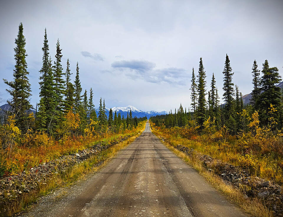
Nabesna Road in the Fall. Photo by Wrangell Mountain Wilderness Lodge
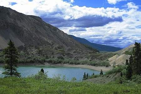
Drive down the 42-mile Nabesna Road for tremendous views to rival any road system in Alaska. The Wrangell, Mentasta and Nutzotin Mountains create a majestic panorama, characterized by some of the highest mountains in North America. Nabesna Road is one of two that allows access to Alaska’s largest national park, the Wrangell-St Elias National Park and Preserve. Nabesna Road is located on the north side of the park. McCarthy Road provides access on the south side of the park and offers more services at the end of the road, including accommodations, dining, guide services, air taxis, and explorable Kennecott copper mine ruins. As a result it is much busier.
Nabesna Road wasn’t built to access the park. In fact, it was constructed in 1933, nearly 50 years before Wrangell-St. Elias was established. The purpose: to get supplies in to Nabesna gold mine, and ore out to the Port of Valdez. The mine operated from 1931-1939 and again for a short time during World War II. Before the road was built, high grade ore concentrates had to travel by packhorse, airplane, truck, train and steamship, finally arriving at the Tacoma, Washington smelter.
A drive down Nabesna Road reveals few landmarks from that time. There are some homesteads that were established in the 1980s, and some old mine buildings remain at Nabesna mine and nearby Rambler mine. Visitors can hike to Rambler mine for an excellent view of the area. Nabesna mine itself is on private property and the area also contains old tailings with high levels of metals and acid. (The National Park Service cautions visitors to avoid it completely.)
For travelers along the Nabesna Road, it’s really about the journey, not the destination. That’s because there’s no infrastructure built up at the end of the road like you find in McCarthy. Nabesna mine, at the end of the road, is not set up as a tourist attraction. However, there are plenty of hiking and camping opportunities for the prepared traveler.
Understanding an indigenous perspective
Learning about the history and traditions of the Ahtna and Tanana peoples of this area can give travelers a deeper understanding and respect for the Nabesna Valley. Wilson Justin grew up here, trapping game and fishing for grayling and salmon. Like all Athabascan youth, indigeneous values and knowledge became ingrained through storytelling traditions. Elders taught the next generations how to live with the rhythms of the landscape and to use those resources provided by the land.
The country may look wild and remote to a casual visitor, but it was never “untouched,” said Justin. “It was always held close to someone’s heart, long before there was ever any intrusion by anybody else.” As you look out onto the mountains, rivers and Nabesa Valley, know that it is a place historically connected to global trade routes, where items from Mexico, Siberia and China would regularly make their way through.
As traders, the Athabascans also knew where gold was located throughout the area. In 1913, Justin’s uncle, “Chisana Joe,” guided prospectors to a gold strike on the Bonanza River that precipitated the last great Alaska gold rush. Prospectors then came looking in the Nabesna Valley. Justin’s father, “Nabesna John,” knew where there was a rich vein high up on White Mountain. As an Alaska Native, however, he could not own property or mining claims. With discovery of the gold inevitable, he made the decision to show the location to prospector Carl Whitham in return for a pledge to treat the family well and employ local people at the mine. There was no written contract, but Whitham was good on his word, recounted Justin.
When Nabesna Road was built to access the mine site, it was neglectful of the locations of existing grave sites and Native camp sites, said Justin. When you travel the road, “keep in mind that there are many places where you are stepping on someone’s name, memory or ancestor’s ghost.”
The Ahtna people maintained a network of trails, kept hidden from Westerners, Justin explained. “Trails were never just trails. They were heirlooms with great intrinsic value.” Trails were owned by specific individuals, and even bequeathed as wedding gifts or otherwise passed down through generations. The more trails a clan had, the more value the clan name had. Traveling on someone else’s trail without permission and consent was akin to entering someone else’s house and fixing a meal for yourself in their kitchen
More About Nabesna Road
It’s remote. Nabesna is definitely “the road less traveled.” You’ll see even fewer people and far less infrastructure than on the McCarthy Road, the park’s other access point.
It requires preparation. Travelers should expect sections of bumpy road, fast flowing creeks, very limited services, and the realities of being in Alaska, including mosquitoes at times. Cell phone coverage becomes unreliable beyond approximately mile 19. The road is paved for the first 15 miles, transitions to gravel, and is again paved between mileposts 24.5 and 29. Beyond milepost 29, there are three stream crossings. Creek levels can rise after rainfall, and four wheel drive with high clearance is recommended, as vehicles may be unable to cross safely during higher water. These conditions typically occur for a short period, usually about one week each year.
The posted speed limit is 35 miles per hour, supporting safe travel and allowing time to enjoy the surrounding views and wildlife. Travelers are often rewarded with expansive scenery and sightings of swans on nearby lakes, as well as bears, moose, caribou, and eagles throughout the corridor. There is no fuel available in Slana or anywhere along the Nabesna Road. Travelers should fuel up in Chistochina, approximately 28 miles south, before beginning the drive. It is also recommended to carry a spare tire, basic insect protection, food, water, and firewood if staying overnight. Cycling the road is possible, particularly by mountain bike, though cyclists should plan to walk bikes through the stream crossings. Checking current road conditions and off road vehicle permissions with the Slana Ranger Station prior to travel is strongly advised.
Not all rental vehicles are permitted on the Nabesna Road. Travelers should confirm gravel road allowances with their rental agency in advance or rent from a company that explicitly allows travel on unpaved roads, such as Alaska 4x4 Rentals, Alaska Overlander, Avis, Alaska Auto Rental, and GoNorth. In the event of an emergency, Avens Alaska can provide limited roadside assistance, including tire repair and basic communications support, offering additional peace of mind while traveling this remote road
It’s historic.
- The Athabascan people have lived in this area since prehistoric times, traditionally moving between river fish camps and hunting camps for moose, caribou and Dall sheep. Two distinct groups lived here: the Tatl’ahwt’aenn (“Headwaters People”), who speak Upper Ahtna Athabascan, and the Ddhał Tot’iin (“Among the Mountains People”), who speak Upper Tanana Athabascan.
- The discovery of gold in the 1920s drove construction of Nabesna mine, Rambler mine and Nabesna Road.
- In the 1980s, “Slana Settlement” was the last homesteading opportunity available in the United States.
- Also in the 1980s, legendary subsistence rights activist Katie John fought for the right to use her family’s traditional fish camp at Batzulnetas (at the confluence of the Copper River and Tanada Creek). She finally won her case in 2001. Katie John first learned English at the age of 14 when she worked at Nabesna mine. She raised her 20 children in the subsistence way of life at locations all along Nabesna Road.
For more information about the people who have lived in the northern section of Wrangell-St. Elias National Park and Preserve, you can read “Along the Ałts’e’tnaey Nal’cine Trail,” produced by the Mount Sanford Tribal Consortium.
Show Map
Driving Guide Points

Stop here for more information about the park and local area, exhibits, and ranger-led activities, as well as an Alaska Geographic bookstore. Always check on current Nabesna Road and trail conditions before beginning your journey. Recreational off-road vehicles (ORVs) are typically allowed on established trails. However, trails can be temporarily closed to ORVs due to maintenance and improvements. ORV permits are required and available at… ...more
The Slana Roadhouse is visible on the south side of the road. This structure was built in the 1930’s, but there has been a roadhouse here since 1912. This roadhouse is one of the few that remain of those that served travelers on the trail from Gakona to Chisana, the site of Alaska’s final gold rush. It is now listed on the National Register of Historic Places.
A short distance of 5 to 6 miles down the Slana takes you to the upper Copper River
“4‑Mile” Road leads into the Slana Settlement, created in 1983 when the BLM opened over 10,000 acres north of the road to homesteading. It was one of the last opportunities for homesteading federal land. Eight hundred claims were filed, but most were soon abandoned. Alaskan winters took their toll. Many tried to live in hastily-built cabins and tents, with temperatures down to ‑60 degrees F. Jobs were scarce and the climate was not suited to… ...more
The north side of the road is “National Preserve” whereas the south side is “National Park.” Sport hunting is allowed in the National Preserve but not in the National Park. However, subsistence hunting is allowed in both the National Park and Preserve.
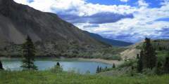
This is a trail with access to Copper Lake. Copper Lake has opportunities for Lake Trout, Grayling, and Burbot fishing. The first 2.5 miles are suitable for hiking, then the trail crossses Tanada Creek, which can be high and fast, and trail conditions deteriorate.
Over the next few miles, enjoy the splendid views of high snow-clad volcanoes of the Wrangell Mountains. Mt. Sanford (16,237′) is the tallest mountain that can be seen from the Nabesna Road. To the left of Sanford is the rounded, icy dome of Mt. Wrangell (14,163′). It is the park’s only active volcano and occasionally steam can be seen rising from the summit. Wrangell’s broad sloping profile is an excellent example of a shield volcano. The… ...more
This is a great site to take a break for some wildlife viewing or bird watching. There are views of wetlands, a small lake, and boreal forest. Moose are often seen here and caribou migrate through this area in the spring and fall. During spring and summer, look for nesting ducks and trumpeter swans. Vault toilets.
The trail proceeds in a northeast direction towards the hills. The trail is an ATV route, and as such there are some muddy areas where you may be required to walk off the trail. The beginning of the trail goes through the valley bottom with low tundra vegetation. Views are great. As the trail continues, the forest surrounds the trail with spruce, alder, willow and wildflowers.
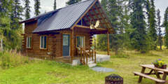
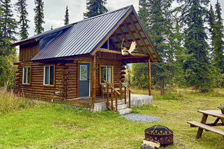
Quaint cabin renovated in 2000, located about 1⁄4 mile north of the Nabesna Road.
This small cabin sleeps two and provides a base camp from which to explore game trails and ridgelines with excellent views of Mount Wrangell, Mount Sanford and Tanada peaks. It’s located at the end of 3‑mile Caribou Creek Trail, which is sometimes accessible by recreational ATV (check with National Park Service first), as well as snow machines when there’s at least 6 inches of snow on the ground.
Mile 21.8 Nabesna Road. This rest area has a picnic table and vault toilet, and looks out over a lake with a view of the Wrangell Mountains.
You have reached the highest point on the Nabesna Road, and crossed a major watershed divide. All waters flowing west and south from the divide are carried byt the Copper River to the Guld of Alaska. All waters flowing to the east ener the Nabesna River, the Tanana, the Yukon, and ultimately the Bering Sea.
Kendesnii Campground, along Nabesna Road in Wrangell-St. Elias National Park, offers 10 wooded sites near the park’s remote northern edge. Managed by the National Park Service, it features vault toilets, hiking trails, and views of the Wrangell Mountains. This quiet campground is ideal for campers seeking to fish, hike to Jack Lake, or spot wildlife in Alaska’s vast interior wilderness.
Comfortable year-round lodging, firewood, airstrip, fishing licenses, tavern, snacks, liquor store, showers, secure parking, local area information, tire repair supplies, and emergency telephone service on the Nabesna Road inside Wrangell St. Elias National Park and Preserve
This spectacular backcountry route connects the Lost and Trail Creek drainages via a 6000’ pass. Explore these trails as day hikes from Nabesna Road or as one big loop in either direction over 3 to 4 days. Trail Creek and Lost Creek were used by generations of Ahtna people, who hunted moose and trapped gophers and porcupine. In the 1930s a few cabins were built at Lost Creek and the Ahtna residents made a living hunting, fishing and selling… ...more
Highlights: Wildlife, open tundra, spectacular scenery. Soda Lake was created by a large landslide, most likely in response to an earthquake and past movement along the Totshunda Fault. The fascinating terrain near the outlet of Soda Lake resulted from the landslide, creating a topography which contrasts from its surroundings. The lake now seeps through this landslide rubble.Hazards: Creeks, especially Soda Creek, may be high on hot sunny… ...more
From the trailhead, the trail leads up an alluvial fan, through white spruce forest and alder for approximately 0.8 mile. The trail surface is gravel/cobble and dry.
Access: Trailhead is located at the end of the maintained portion of the Nabesna Road, Mile 42. As you near the end of the maintained portion of the Nabesna Road, you will reach private property owned by the Ellis family, who operate Devil’s Mountain Lodge, established here in the 1950s. Please respect their privacy and take care not to park on their property or private air strip. Continue driving on the road through the Ellis property.… ...more
The discovery of gold at Jacksina Creek in 1899 was an exciting find for prospector K.J. Fjeld, but it proved too remote to develop successfully. Other prospectors were persistent though, and in 1925 Carl Whitham found a rich lode on White Mountain. That find, and his subsequent development of the mine, led to the construction of Nabesna Road. At its height, between 40 and 70 men were employed at the mine. It also provided trading… ...more
Access the Nabesna River at Cabin Creek/Jack Lake for a 55-mile float through the Tetlin Wildlife Refuge down to Northway. For centuries this land was beneath the ancient, glacial Lake Ahtna that formed by the huge ice sheets of the last ice age blocking the Matanuska to the west and the Copper River to the south. At Mile 41 of Nabesna Road take a rough road to the left, down Jack Creek, fording it several times. It’s 5 miles to Cabin Creek.… ...more