Nome-Teller Highway Scenic Drive
Take a few hours to explore the Nome - Teller Road, and you’ll be further west than nearly everyone in the United States. In fact, you’ll be just 55 miles from Russia, and close to the Bering Strait Land Bridge, the ancient migration route between Asia and North America.
The Nome – Teller Road runs 73 miles northwest and takes approximately 2 hours one-way without stops. The gem of the road lies at its end, at tiny Teller, Alaska. Fewer than 300 people live in Teller, and 85 percent of them are Inupiat living a subsistence lifestyle. The small size is even more striking when you know that Teller was once a gold rush boomtown filled with 5,000 people. Stop at the small local store and gift shop or talk to locals about finding authentic hand-crafted native items to purchase.
The scenery along the way is spectacular. You’ll likely see a herd of reindeer grazing in the tundra. It’s owned by a family in Teller and is part of the 25,000 reindeer that roam the Seward Peninsula.
Side Road to Top of Anvil Mountain
For a drive with a view, take this quick route to the top of Anvil Mountain. Right outside Nome, it’s about 4.5 miles (15 minutes) one-way. Here you’ll find the abandoned White Alice Site, an early distant warning site left after WWII. But even better, on a clear day you’ll have an expansive view of the city of Nome, the Bering Sea, Sledge Island, and the surrounding tundra.
Show Map
Driving Guide Points

Open only in summer, the five-mile long Dexter Bypass Road links Teller Road and Kougarok Road and offers additional opportunities for muskox viewing. Access to Anvil Mountain is on the left, about a mile from the Teller Road.
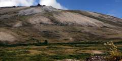
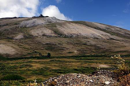
“Nomehenge,” as some of the locals call the four towering antennas on Anvil Mountain above Nome, operated during the height of the Cold War to link remote parts of Alaska with the rest of the country. These are the last of 71 White Alice structures, and serve as important historic and geographic landmarks in Nome.
This approximately five-mile, gravel, side loop passes through some popular blueberry picking spots and is often a good area to view muskox. The road overlooks the Anvil Creek mining area before joining up with the New Glacier Creek Road at Glacier Creek.
Teller Road crosses Anvil Creek one mile below the site of the 1898 gold discovery that triggered the Nome gold rush. From here you can view the wind turbines that form the start of Nome’s efforts to harvest wind as an alternative energy source.
Glacier Creek Road runs approximately 30 miles up the east side of the Snake River. It becomes a rough four-wheel-drive road after it passes the Rock Creek Mine site three miles in and is not maintained in winter. If you look north up the valley from Teller Road, you will see the pyramid-shaped peak of Mount Osborn, the tallest peak on the Seward Peninsula. Look for birds nesting in the small lakes on either side of the road.
The Snake River has a relatively short drainage that flows out of the south side of the Kigluaik Mountains. Prime moose, birding, and salmon viewing habitat.
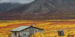
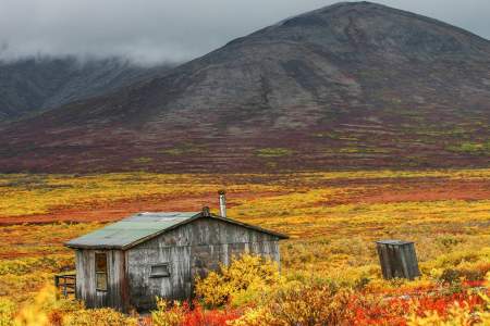
On the left as you head north are remnants of an abandoned reindeer corral that was first constructed by the Bureau of Indian Affairs in the 1970s for a reindeer herding demonstration project. The local Sitnasuak Native Corporation took over the corral in the early 1980s and ran a herd of about 750 animals for several years. The corral fell into disuse after Sitnasuak got out of the business and distributed the reindeer to other herders.
Seven miles off the coast, Sledge Island is visible on clear days from this section of Teller Road. Originally named Ayak, the island was home to about 50 Ayakmiut, who primarily hunted seals but also walrus when those animals migrated close to shore.
The bridge crossing gives a good view of birdlife, spawning salmon, and moose. Red-breasted merganser and harlequin duck like the swift-flowing water.
Driving north, the rocky outcrop on your right may host a nesting or perching site for rough-legged hawk, gyrfalcon, and common raven. Look to your left into the creek bottom to see an active beaver lodge with several dams and ponds.
House Rock and Cabin Rock are local names for the obvious rock formation on the right. Look for Arctic ground squirrel on the dry, upper slopes and for Musk ox on the windblown summits. This is also a great birding area.
This gravel pit opens up onto a ridge that overlooks Arctic Creek and the hills to the north. It’s a great spot to pull off the road and look for musk ox, moose, or bear in the brush across the valley.
The steep road grade on either side of Cripple River gives a good overview of the thin thread-like river that runs through the valley. Gold mining activities occurred in the upper tributaries, as evidenced by the road and horizontal ditch lines. Look for harlequin ducks paddling swift river currents in late August or September, and Pink Salmon swimming upstream to spawn.
Heading north, there are two turn-offs for tundra ridge hiking with great views of the surrounding area
The Sinuk River is the largest river crossing on the Teller Road, and the magnitude of the valley, river channels, craggy mountains, and rolling tundra — all in one panoramic vista — is an impressive sight. The bridge is a reliable spot to see salmon on their return upriver. Birdlife tends to be those species attracted to flowing water and gravel bars, islands, and thick vegetation clustered in some sections of the river.
The crest of the hill north of the Sinuk River offers a spectacular view of the Kigluaik Mountains on a clear day.
Just south of Livingston Creek, the tundra next to the road has sloughed away and exposed the permafrost beneath the surface layer of tundra plants and soil.
The Feather River is a noisy, rocky, boulder-strewn river with a steep gradient, fast flow, and little vegetation. The landscape seems more barren, probably resulting from the impact of constant wind, long winters, and poor soil. Muskox and reindeer may be seen here, but other wildlife sightings are less frequent in this drainage.
The next several miles of road offer views of King Island in clear weather. The island is ideally situated for harvesting the many seals and walruses that pass through the Bering Strait.
This creek at mile 40 is adjacent to the turnoff to the Woolley Lagoon fishing camps. A quick right turn from the turnoff puts you at a favorite water collection point by locals who believe the creek, as well as having the best tasting water around, also has healing powers.
This 100-foot-wide road is a public right-of-way that traverses lands privately owned by the King Island Native Corporation. It runs eight miles to traditional summer fishing camps at Woolley Lagoon. Please stay within 50 feet of either side of the road. Do not photograph or travel close to lagoon or camps. A pull-off to the right offers views of Moon Mountains, a wintering spot for muskox. Also watch for red fox and black-bellied plovers. ...more
As you approach the Tisuk River, scan downstream and across the river for a large nest of sticks on an orange lichen-covered rock outcrop. Built by golden eagles, it may be used by gyrfalcon when not occupied by eagles.
The Tisuk River valley near the bridge is subject to huge ice build-ups that extend over the gravel bars and riverbanks and are slow to melt in the spring. Because of the ice, this area is poor fish habitat and willow growth is sparse along the riverbanks.
The road parallels a somewhat narrow creek valley, making it easy to see water and shorebirds associated with flowing water as well as the wide variety of songbirds, such as thrushes, warblers, and sparrows that hang out in dense shrubs clustered at creek’s edge. Arctic grayling, and sometimes pink salmon, are found here.
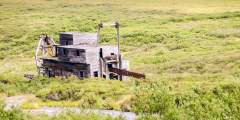
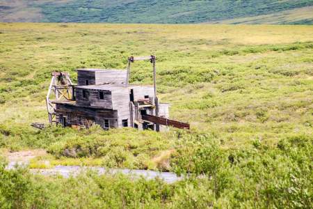
Miners worked this dredge up and down the Bluestone River and Gold Run Creek in the early 1900s. Now it serves as a nesting and perching site for common raven.
Once a bustling mining camp and supply center, Sullivan City sprang up downriver from the dredge. Several small-scale mining operations continue today. This is privately- owned property and trespassing is forbidden.
The Bluestone River is unlike other river crossings along the Teller Road because it flows northward to Imuruk Basin rather than south to Norton Sound. The river is deeply incised as it cuts through steep mountains, creating steep, rocky slopes and cliffs. Rough-legged hawk, golden eagle, gyrfalcon, and common raven may nest on nearby rock cliffs
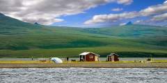
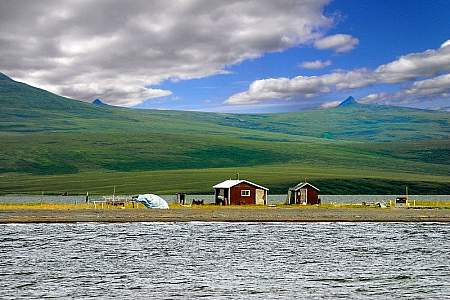
At Teller the road returns to sea-level where the environment is dominated by marine waters. Look for spotted seals on calm days, their heads popping up inquisitively at the tip of the spit. Pelagic cormorant, pigeon guillemot, horned puffin, common eider, and black scoters are seen here.