Alaska’s Most Photo-Worthy Bridges
These bridges of the Last Frontier anchor some of the most spectacular views in the world, with uncanny potential for great photographs. They range from engineering marvels that span gorges to historic structures that invite exploration on foot—all worthy destinations all on their own. Think of them as a gateway into history and local lore. Because Alaska has far fewer roads and highways than other states, bridges become exceptionally important to local transportation. Any given bridge might offer local travelers the only way across a river or gorge with no practical alternative route. As a result, many Alaska bridges are known by their names rather than their locations!
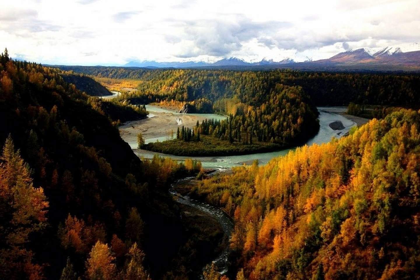
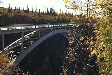
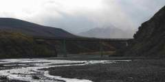
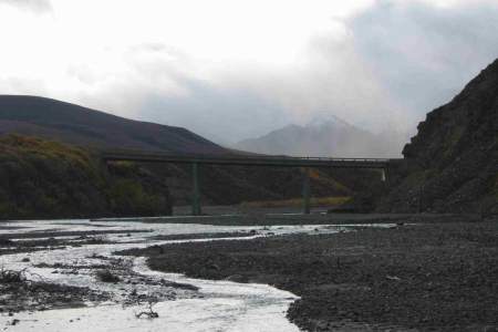
Overlook Hurricane Gulch from the bridge on a vibrant autumn day
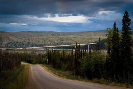
Hurricane Gulch
About 150 miles north of Anchorage on the Parks Highway and Alaska Railroad
These two steel arch bridges cross Hurricane Gulch about halfway between Anchorage and Fairbanks, one on the Parks Highway and the other on Alaska Railroad.
The train bridge may be the most famous and scenic bridge in Alaska, subject of many iconic photographs. It reaches 296 feet above Hurricane Creek for a full span of 918 feet—the longest and tallest bridge on the Alaska Railroad. For the first eight years after its completion in 1921, it was the tallest bridge in the United States. Even now, it’s a major highlight for passengers on the Hurricane Turn Train, where the train slows crawl as it eases out over the gorge to allow for photos and sheer amazement.
The highway bridge crosses the gulch at Mile 174.3—about three-quarters of a mile due east of the railroad bridge. Built in 1971, the bridge reaches 558 feet across the gorge—254 feet above the creek—offering a setting almost as stunning as its railroad sister down the hill. Park in a lot about 150 yards north of the bridge on the west side of the highway. You’ll find good overlooks for photography a safe walk from parking.
NOTE: Is it possible to hike from the highway bridge to find an overlook of the railroad bridge to recreate one of those fabulous shots of the train crossing the trestle? Not recommended. While less than a mile apart as the raven flies, the two bridges are not really directly accessible. It’s not impossible, but people who have hiked in from the Parks Highway report that they spent hours bushwhacking across very rugged terrain. There’s no designated trail and no obvious overlook.
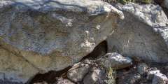
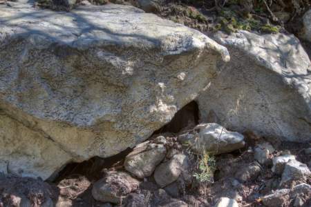
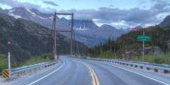
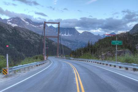
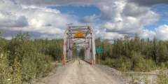
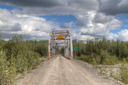
Old Knik River Bridge
About 46 miles from Anchorage on the Old Glenn Highway
The span built in 1936 for the first highway connection between Palmer with Anchorage is now a walking path, closed to vehicle traffic, just upstream from where the present Old Glenn Highway crosses the Knik River at about Mile 8.7. It runs parallel to the new Knik River Bridge that replaced it, itself an interesting span. Park to the side in the first yards of the Knik River Road on the west side or in a pullout on the east side of the river, and scramble onto the old concrete deck. You’ll find a dramatic stroll, with mile-high Pioneer Peak looming above and the roiling, glacier-fed Knik River hissing a few yards below. Guerilla street art festoons the bridge’s beams and trusses, too, beguiling you with strange characters, abstract images and cryptic aphorisms. A weird and wonderful place.
Kuskulana Gorge
East of Chitina on the McCarthy Road
This single-lane, wooden decked bridge crosses the gorge of the Kuskulana River about Mile 17 of the McCarthy Road in Wrangell St.-Elias National Park east of Chitina. For many heading to McCarthy and Kennecott, creeping across the narrow bridge at an idle—238 feet above the raging river—is the most harrowing part of their trip. Built during the winter of 1910, the bridge was a key element in the railroad linking the port at Cordova with the copper mining operation at Kennecott.
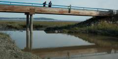
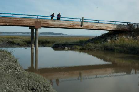
Placer River Bridge
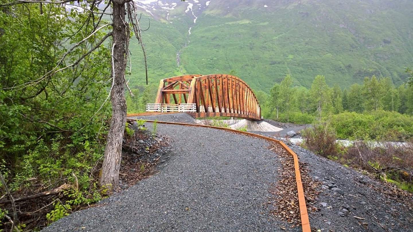
Enjoy a stroll across Placer River Bridge
On a trail near Spencer Glacier along the Alaska Railroad
One of the most remarkable and striking footbridges in Alaska crosses the Placer River about a mile or so from the Spencer Glacier Whistlestop on the Alaska Railroad, about 10 miles from Portage on the Seward Highway. The 280-foot bridge—made largely from Alaska yellow cedar—was placed 25 feet above the water to make room for icebergs and floes flushing from Spencer Glacier Lake. The bridge (which currently leads to a dead-end trail) is the longest single-span bridge of its type in North America. It will eventually be a key crossing on the backcountry Glacier Discovery hiking route from Spencer Glacier to Grandview Whistlestop and Trail Glacier, under gradual construction by Chugach National Forest. Just off Spencer’s main path between the train station and the lake, the bridge is already one of the most photographed attractions at the Spencer Glacier recreation area.
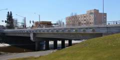
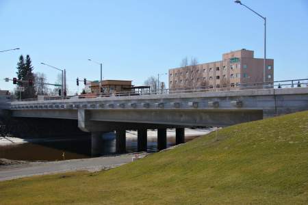
Cushman Street Bridge
In downtown Fairbanks
Right in downtown Fairbanks, this historic concrete and steel bridge has spanned the Chena River since 1917 (and will be upgraded in a few years.) The state flags of all 50 states flutter over its two sidewalks, raised in 1984 to commemorate Alaska’s 25th year of statehood.
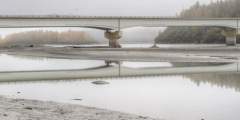
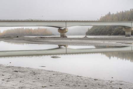
E. L. Patton Yukon River Bridge
About 140 miles north of Fairbanks on the Dalton Highway
The only road crossing of the Yukon River in Alaska, this 2,290-foot girder bridge carries both vehicle traffic and the Trans-Alaska Pipeline, at Mile 55.4 of the Dalton Highway to Prudhoe Bay. Built as part of pipeline construction in 1974, the bridge is named for the project’s supervisor. It has an unusual and perhaps startling six-percent grade—descending south to north—and soars 200 feet above the river at its highest point.
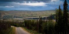
Canyon Creek bridges
On the Seward Highway in the Kenai Mountains about 70 miles from Anchorage
Two very striking bridges—one old and now used as a bike path and walkway, the other a technically difficult feat from 1997—curve over Canyon Creek where it emerges from a gorge at the junction of the Seward and Hope highways about Mile 56. The new bridge—about 90 feet above the creek—reaches 885 feet in a span supported by concrete pillars. It won a national engineering award upon its completion. The old bridge—accessible from the southbound Canyon Creek Rest Area—used to be one of the most harrowing, white-knuckle curves on the Seward Highway, notorious among winter drivers. Now it’s a fun stroll with a postcard worthy view of the gorge.
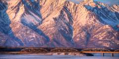
Mears Memorial Bridge
Where the Alaska Railroad crosses the Tanana River in Nenana, about 57 miles from Fairbanks
The historic Million Dollar Bridge
Built between 1921 and 1923, this old-time steel truss bridge marked the completion of the Alaska Railroad, allowing trains to roll from tidewater in Seward and Anchorage to Fairbanks for the first time. Its 700-foot-long reach made it the longest bridge of its type in the United States (and still remains the third longest.) President Warren G. Harding tapped home the ceremonial golden spike at the bridge’s north end on July 15, 1923. On the east side of town, see the bridge from the beach along the Tanana or from Front Street. It is about 1,250 yards upstream from the Alaska Natives Veterans’ Honor Bridge of the Parks Highway.
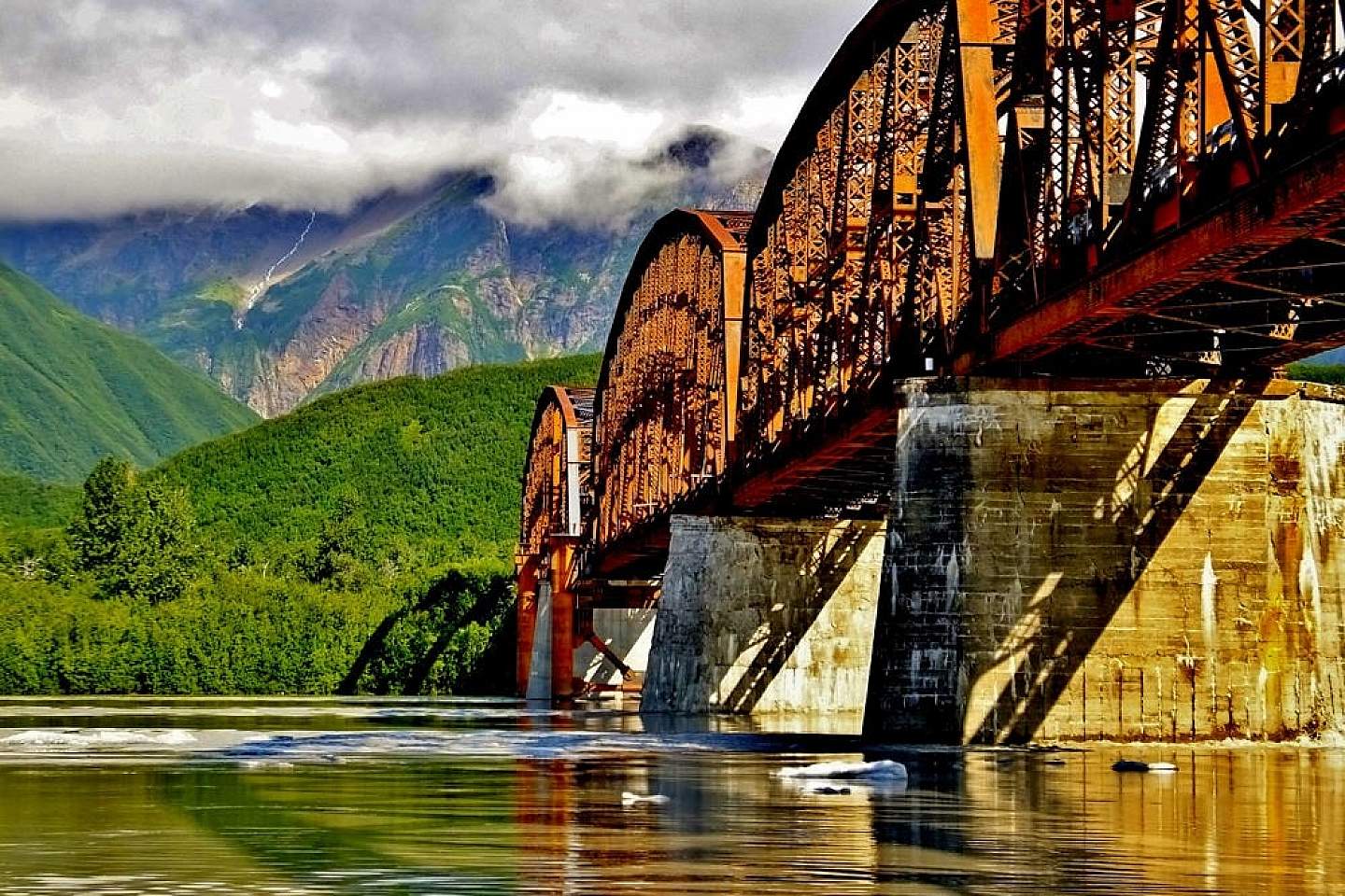
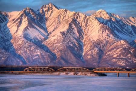
Miles Glacier Bridge (the Million Dollar Bridge)
This 1,550-foot steel truss bridge over the Copper River about 48 miles east of Cordova on the Copper River Highway earned its nickname for a $1.4 million price tag—a colossal sum when it was built in 1910. At the time, the bridge was the crux of the 196-mile railroad connecting the port of Cordova with the copper mining operation at Kennecott in what is now Wrangell St. Elias National Park. Later, after the Great Alaska Earthquake of 1964 knocked its northern-most section off supports, photos of the off-kilter span became iconic of the temblor’s damage, one of the most famous images of modern Alaska. Listed on the National Historic Register of Historic Places in 2000, the bridge was reopened to traffic in 2005. Note: A bridge at Mile 36 is currently impassable (2020.) Contact the Cordova Ranger District for information about venders offering access to the Million Dollar Bridge area.
Show Map
Bridges
This bridge is the connection between southcentral Alaska and the interior of the Territory. The bridge represents an engineering marvel for the day and age it was constructed, and is as strong today as when it was constructed nearly a century ago.
With mountains overhead and a rushing river below that reflects the light in its swirling patterns, this bridge makes for a scenic crossing. You have to drive the old Glenn Highway to get here, but it’s a nice alternative to the main Glenn Highway.

For many, crossing the Kuskulana Bridge is the most nerve-racking part of their drive down McCarthy Road. Mentally prepare yourself to drive across this old single-lane railroad bridge 238 feet above the raging Kuskulana River! The Kuskulana bridge was built during the winter of 1910. You will see for yourself what a remarkable achievement this was.
All 50 states are represented by their state flag on this concrete and steel bridge built in 1917. Festival Fairbanks, Inc. and the Downtown Association of Fairbanks, both local community organizations, raised the flags to commemorate Alaska’s 25th year of statehood in 1984. The first bridges in that location were temporary wooden constructions that were destroyed every year by the powers of spring breakup. Open to the public.
This ½‑mile-long span is one of only four vehicle-carrying bridges across the mighty Yukon, the longest river in Alaska and the Yukon Territory, and a primary means of transportation during the Klondike Gold Rush.
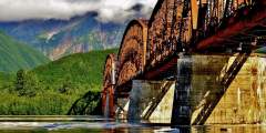

Construction of this early-1900s bridge cost a whopping (at the time) $1.4 million, which earned it the nickname Million Dollar Bridge. But the bridge quickly earned its keep, allowing the railroad to haul copper from Kennicott to the port of Cordova.
Veterans’ Memorial Bridge opened with fanfare in November of 2012. A procession of antique cars borrowed from the Fountainhead Antique Auto Museum and private collections were the first wheels to cross the bridge, keeping in the tradition of historic bridge openings in Fairbanks. Veterans from Fairbanks marched in step and presented the colors at the mid-way point. Local, state, and federal dignitaries were on hand for the event and the ...more
Pelican Creek Bridge is just a few minutes from Pelican’s harbor. This is a great place for viewing salmon that are headed upstream to spawning sites. Check it out in July and August for the best viewing opportunities.
Look closely in the limestone outcroppings to the northeast of the bridge, and you will spot fragments of fossil coral. This limestone was formed on the floor of a shallow sea about 400 million years ago. Pieces of a coral reef, broken by storm waves, came to rest in the soft lime mud. They eventually turned to rock and were uplifted into folded mountains about 150 million years ago. As always, please leave the fossils for others to see, and… ...more
Surprise! This bridge over the Susitna River appears without warning, so if you want to stop and see this huge drainage, slow down and pull off the road at either end. Alaskans call it the Big Su. We fish it, paddle it, and snow machine its frozen braids. Bush pilots even navigate by this river. The Susitna River winds its way over 313 miles of Southcentral Alaska; this old railroad bridge crosses the water on the eastern edge of Denali… ...more
This unique bridge spans 110-foot over Moore Creek Gorge. Named for Captain William Moore, a pilot, prospector, packer, trader and riverboat captain. He played an important role in the founding of Skagway and helped pioneer the route over White Pass. Captain Moore was one of the first people to realize the potential for a railroad over the pass.
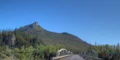
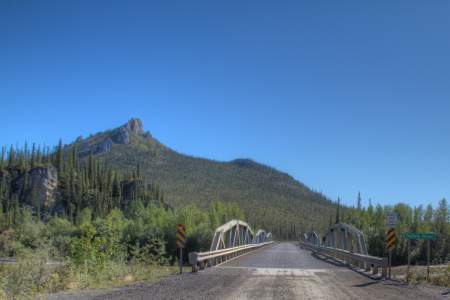
The mountain range to the right is Devil’s Prongs and Barometer Mountain is to the left.
This bridge, connecting downtown Juneau with Douglas Island, was built in 1981, though the original bridge dates to 1935. Today you can walk, bike, or drive across this bridge for a very scenic view.
Alaska has a fascinating archeology. The fossilized remains of many species of pre-glacial Alaskan mammals have been discovered here. These fossils are on display at the University of Alaska Museum in Fairbanks as well as the museum in Central.
A popular place for viewing wintering Emperor Geese.
Watch for cattle as you drive through open range. You can admire the views from the bridge, or take the trail up Sharatin Cirque & Mountain and explore flowery slopes and signs of wildlife, including Mountain Goats, Pipits, and Ptarmigan.
Rock Creek is the first of many waterways that the Denali Park Road crosses. In constrast to many glacial fed rivers, Rock Creek is contained in a defined channel at this point. Just upstream of the bridge is C Camp, a maintenance site for the area that has had ongoing clean-up efforts to contain and dispose of contaminated soil.
It’s not just floods and avalanches that shut down remote roads in Alaska. In this case, a bridge was heavily damaged by a rogue trucker with an over weight load! According to local legend, after nearly destroying the bridge, the (alleged) culprit drove away and was never seen again.
This pedestrian-bicycle bridge connects the north bank near Doyon, Limited to the south bank of the Chena River adjacent to the Alaska State Court House as part of the Chena River Pathway system.
Sheer cuts along river bank reveal a heavy volcanic ash layer from the eruption of 1912.
Recently reconstructed from two lanes of traffic to four, this is one of only three bridges that span the Kenai River.
Arctic grayling, northern pike and dolly varden are common in the Ogilvie River. William Ogilvie was a prominent Canadian land surveyor who began working in the Yukon in the summer of 1887. His first task was to determine the location of the boundary between Canada and Alaska at the Yukon River.
This 1255-foot-long bridge has reserved its place in history by being America’s first cable-stayed girder spanned bridge. Today, it connects Sitka, on Baranof Island, to the town’s airport, which is on Japonski Island. Finished in 1972, it was named after a former mayor of Sitka.
At Milepost 67 Taylor Highway you will find the Chicken Creek Bridge. This is the site of a dredge that was operated by the Fairbanks Exploration Company from 1959 until 1965. In an average run of the dredge, it was operating 24 hours a day for 2 weeks. At it’s peak, one run would bring in $40,000 in gold.
You’ll see a water gauging station in the middle of the bridge. This was part of a flood control project built by the Army Corps of Engineers in response to the 1967 flood that devastated Fairbanks.
This short wooden bridge crosses a popular salmon fishing creek. Downriver you’ll see deep channels that the creek has carved into the mud flats. In late summer, salmon migrate up to the estuary to spawn.