Nome-Council Highway Scenic Drive
The Nome - Council Road runs east of Nome 72 miles and takes 2 hours one-way without stops. For the most variety and plenty of Alaskan character, take this road to the community of Council. You’ll head out of town along coastal flats, grasslands, and wide, sandy beaches, following the coast of the Bering Sea northeast for about 30 miles before turning inland. Get out and beachcomb for old artifacts and beach glass washed ashore by storms. Stop at Safety Sound, a prime area for birdwatching, and enjoy refreshments at Safety Roadhouse, the last checkpoint on the Iditarod. Like thousands of past patrons, you’ll want to leave your mark here by signing a dollar bill and sticking it on the ceiling, wall, or doorframe.
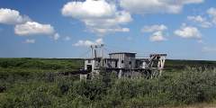
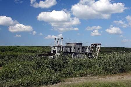
One of the most famous sites around these parts, the “Last Train to Nowhere,” comes into view at around 33 miles. This remnant of the Council City and Solomon Railroad is sinking slowly into the water-logged tundra, where it’s been for more than 100 years. Head out to the viewing platform, for a quintessential photo. Continuing on, you’ll see that many rivers cross the road. Even if you’re not fishing, stop and enjoy the crystal-clear view to the shallow river bottoms. Another thing to watch for in summer: dried fish hanging from driftwood racks at many of the camps along the way.
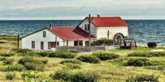
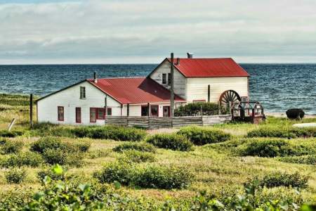
As you approach Council, you may notice one of the things Nome residents like best about it…there are trees! Many Nome-ites collect Christmas trees from this area before the road closes in the fall. At the end of the road, you’ll find that a river crosses the entrance to Council. Nome residents cross this river in their cars regularly, but it is important to know the routing to avoid large holes. It is not recommended that visitors attempt this crossing without assistance. Instead, turn right and you’ll come to an area from which local residents cross in boats. You may be able to catch a ride from someone going across by boat or car.
You won’t find many people in Council. Very few families live here year-round, although 30-40 more families reside here during the summer months. It’s quite a change from gold rush days, when some 15,000 people lived here while chasing their dreams. Still, some of the old log cabins still stand, making it a fun little town to explore.
Show Map
Driving Guide Points

Beginning in the summer of 1899, thousands of men, women, and children worked shoulder-to-shoulder to glean treasure from these shores after news of Nome’s “Golden Beaches” rocketed around the world. To this day, hearty independent miners continue to work many area beaches with high bankers and sluice boxes. Most find themselves braving the cold waters in wetsuits to operate small, modern, floating suction dredges essentially vacuuming ...more
The bridge marks a mixing zone where fresh river water meets tidal salt water and turns brackish. This creates a blend of water types and habitats and attracts many different birds to areas of open water or the mud-bar edges of islands. Look for geese, cranes, shorebirds, and gulls in good numbers, even unusual species like Arctic loon, red knot, black-tailed godwit, red-necked stint, ivory gull, and white wagtail. Also spot spawning salmon. ...more
Beyond the bridge, a long line of small buildings hugs the coast where a U.S. Army post once stood during the early gold rush. Fort Davis was dismantled in 1923 as Nome’s economy declined. The buildings you see today are locally-owned hunting and fishing subsistence camps. The Inupiat used this area well before the soldiers arrived because of diverse and abundant birds, fish, and mammals. Please do not disturb or trespass.
As you round Cape Nome, the Cape Nome Roadhouse is on the shore-side of the road. Road-houses once flourished along trails around the state, providing food and shelter for winter travelers who often arrived by dog team or horse-drawn sleigh. The Cape Nome Roadhouse also served as an orphanage after the devastating epidemics of the early 1900s and as a World War II communications base. It is now a privately-owned camp.
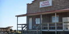
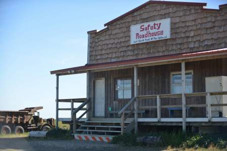
The Safety Sound roadhouse still opens in summer to offer travelers shelter from the rain or a cool beverage to wash down the dust. It’s closed the rest of the year except for several weeks in March, when it serves as the final checkpoint for the Iditarod Trail Sled Dog Race. The Safety Bridge is a good vantage point to watch changing tides and the movement of large and small fish and their predators. Scan for the bobbing heads of seals ...more
Immediately after the bridge, a turn-off on the inland side of the road leads to several interpretive signs and a boardwalk for wildlife viewing.
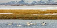
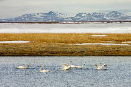
Safety Lagoon slowly narrows and mixes with wetlands, ponds, and the Bonanza River estuary. Thousands of tundra swan move through this area on their spring migration. Breeding swans move on to upland ponds to nest and raise their young, while non-breeding birds may remain all summer. In the fall, parts of the lagoon and Solomon River wetlands turn white with huge groups of swans preparing for fall migration.
In the fall, people fish for tomcod from the bridge. Deep diving ducks feed in the channel depths of the Bonanza River. Sandhill crane feed on berries, plant shoots, roots, insects, and even small rodents. Red-throated loon and, less commonly, Pacific loon float the waters.
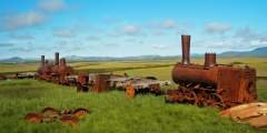
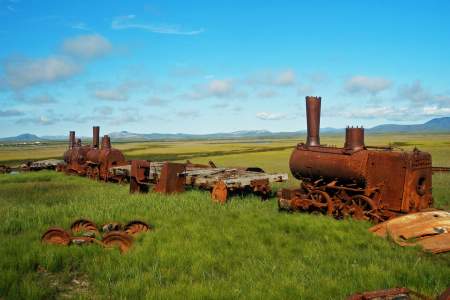
Just across Bonanza Bridge, three rusty steam locomotives and some rolling stock lie sinking into the water-logged tundra. Dubbed “The Last Train to Nowhere,” they are all that remain of a dream to build the most extensive and prosperous rail system on the Seward Peninsula. In the early 1900s, Chicago investors backed construction of the Council City & Solomon River Railroad in an effort to link the region’s major mining centers by rail. ...more
The town of Solomon has had several names and locations since the Fish River tribe established a fishing and hunting camp called Amutach on a sandbar between the Bonanza and Solomon Rivers. In 1899, when gold was discovered in the gravels of the Solomon River, a mining boomtown sprang up on the site with a post office, several saloons, a railroad terminal, a ferry dock, and over 2,000 residents. Thirteen large dredges worked the Solomon River. ...more
Shovel Creek passes under the road through a double culvert before it enters the Solomon River. A year-round spring that feeds the creek near the road keeps the water from freezing in winter. This attracts dippers, beaver, mink, and otter and encourages the growth of cottonwoods. The spring-fed creek also offers a moderate amount of spawning habitat for pink, chum, and coho salmon in late July and August. Dolly Varden are present but few Arctic ...more
Lee’s Dredge, the last dredge to work the Solomon River, was operated by the Lee family until the 1960s. It now provides nesting platforms for raptors and ravens. You may see green-winged teal and phalaropes feeding in the dredge pond and songbirds in the surrounding willows.
An old road bed leading to a Solomon River overlook is a good spot to look for salmon, Dolly Varden, and Arctic grayling in late July and August. Say’s phoebe will launch from its nest to catch insects. Northern shrike, harlequin duck, spotted sandpiper, and wandering tattler are also seen. In some years, the cliff is occupied by common raven, rough-legged hawk, or other raptors so be careful your presence does not disturb nesting birds.
In 1904 a telephone line ran from Nome to the railroad terminus at Dickson, to the mining camps up Big Hurrah Creek, and on to Council. For one brief summer, parcels could be mailed to any point in the U.S. and money orders sent worldwide. The Council City & Solomon River Railroad also ran past, offering miners a one-hour trip to the coast. Grizzlies, moose, muskox, and reindeer are frequently sighted between the creek and East Fork Bridge. ...more
Approaching the East Fork of Solomon River, a wide pull-off on the left is an excellent place to park and scan the slopes and river valley for wildlife. Northern wheatear and American pipit frequent the rocky slopes nearby. Cliff swallow often build nests on the bridge supports, and ravens and raptors occasionally nest in the area. This view of the river makes it easy to find red-breasted merganser, harlequin duck, tattlers, and gulls.
The rocky outcrop across the Solomon River usually hosts an active golden eagle nest. Look for a huge tower of sticks and splashes of whitewash and orange lichen in the vicinity of the nest and surrounding perching sites. Built by eagles and added onto in successive years, the nest i s distinctive for its large size, construction, and shape. When not occupied by eagles, the large nest may be used by gyrfalcons.
Descending into terrain increasingly dominated by trees and willows, you are more likely to see a moose than a muskox. In late summer grizzlies feed on spawning chum salmon below the Fox River bridge. Salmon carcasses also attract red fox, gulls, and common ravens. Both abandoned and active beaver lodges and dams are found along the Fox River drainage. Dolly Varden, Arctic grayling, and chum and pink salmon can be seen from the bridge. ...more