Stretching from the Alaska Range in the north to the Talkeetna and Chugach ranges in the east and south, the massive Mat-Su borough covers an area roughly the size of West Virginia.
Starting in Anchorage, you’ll head north on the Glenn Highway. The first major fishing spot here is the Eklutna Tailrace, a popular spot to to catch Kings in early May (if permitted by ADF&G) as well as silver salmon later in the summer. After passing the Palmer Hay Flats, stay on the Glenn by taking on off-ramp towards Palmer. The lakes in the Matanuska Lakes State Recreation Area are stocked. Continue on the Glenn toward the Matanuska Glacier and you'll find other accessible lakes from the road system for a quiet afternoon of fishing.
Northbound? The same junction where the Glenn heads east is also the start of the Parks Highway. The Parks Highway passes through Wasilla. Beyond Wasilla lie the more rural communities of Houston, Big Lake, and Willow. You'll find a mix of neighborhood lakes to fix, as well as access points for some of the most popular fishing areas in the state, such as the Susitna River, Little Susitna River, Montana Creek, and more.
Need gear or a guide? Contact the Bait Shack in Anchorage. Or connect with Phantom Tri-River Charters in Talkeetna.
Show Map
Fishing Spots
Glenn Highway & Palmer
1

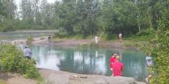
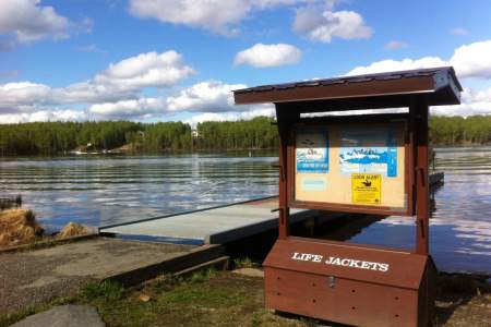
This unique fishery, about 25 miles north of Anchorage, is comprised of a small, artificial eddy of water that comes down from a power plant and connects to the main stem, Knik River. The glacial-fed water looks murky and blue-gray, and there’s very little current. While you won’t find much solitude here, you can usually find a spot to set up a lawn chair for some lazy fishing. There’s abundant parking, too, as well as restrooms.
2

Popular for sockeye in early August, and silvers from Mid-August with late runs through October. From the parking area at the Jim Creek Campground, it is about a 1.5 mile trail to the river. This area is extremely popular for locals to explore on ATVs and dirt bikes.
3
Matanuska Lakes (Kepler Bradley) Campground, at Mile 36 of the Glenn Hwy near Palmer, offers 9 RV sites and 8 campsites by Kepler Lake. Surrounded by spruce forest with lake access, trails, vault toilets, and fire rings, it’s a peaceful base for trout fishing, canoeing, and hiking the Matanuska Greenbelt — just minutes from the charm of downtown Palmer.
4
5
Small lake in Palmer, Alaska with great public access, including a parking area (with fee station) for about 4 – 5 vehicles, and public toilets. Fish for rainbow trout and arctic grayling.
6
7
Annually stocked lake for landlocked salmon (silvers/coho) within the Matanuska Lakes State Recreation Area. You can reach the lake via the Matanuska Lake Trailhead or the Long Lake Trailhead.
8
North Knob Lake is accessible via the ALASCOM Access Road off of the Glenn Highway, just across the road from the Chickaloon Trailhead System. There is a small gravel pullout for parking. The lake is stocked with rainbow trout.
9
North Knob Lake is accessible via the ALASCOM Access Road off of the Glenn Highway, just across the road from the Chickaloon Trailhead System. You’ll first past North Knob lake before reaching South Knob Lake. The lake is stocked with rainbow trout.
10
Lake stocked with rainbow trout. Accessible via Bonnie Lakes Road off the Glenn Highway just north of Chickaloon. There’s a gravel pull-out parking area on the right hand side of the road to access the lake.
11
Lovely lake accessible from via Bonnie Lake Road off the Glenn Highway just north of Chickaloon. A small dock juts into the lake, as well as a gravel boat launch area. Fish for rainbow trout and grayling.
12
Seventeenmile Lake is stocked with rainbow trout and arctic char. It’s a tranquil lake with views of the surrounding mountains. The lake can be accessed from the Glenn Highway, just before Sutton, via Mile 58 Road. There’s a small gravel parking area and undeveloped boat launch off of Wishbone Place.
13
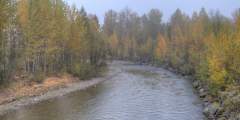
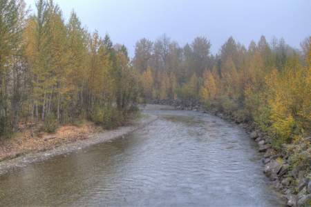
A good dirt road, with plenty of pull-outs, leaves the main highway on the south side of the road. The “Alascom Road” runs four miles across the valley floor. There are several lakes, stocked with trout and grayling, for fishermen, and plenty of camping spots. It’s quiet, and there’s great canoeing and bird watching on the lakes. It’s a popular weekend destination for Anchorage folks, so you might not be alone. And in the fall, you’ll see plenty ...more
Wasilla, Big Lake, & Willow
14
Most of this lake is lined with private property, but it there is a small parking area and public access trail off N. Windy Bottom Road. The lake is stocked with rainbow trout.
15
Quiet lake in Wasilla mostly lined with residential properties. There’s parking and a gravel boat launch off of S. Beaver Lake Road. The lake is stocked with Rainbow Trout.
16
Large campground in Wasilla, Alaska managed by the city of Wasilla. There’s a 57-spot campground, 3 large pavillions, fields, a playground, and a boat launch for watersports. The lake is stocked with Rainbow trout and is popular in summer, as well as for ice fishing in winter.
17
Lovely neighborhood lake in Palmer, just off of Trunk Road. There’s a public access point on the north side of the lake off of E Turn Drive. There’s a small gravel parking area. The lake is stocked with rainbow trout. Locals come here to fish and paddle.
18
Avoid the crowds and explore a local favorite. This 6.2‑mile out-and-back trail, located in Willow, Alaska, takes travelers on a winding journey along boreal forest floor. The payoff is at the turnaround point, which features views of Red Shirt Lake’s shoreline. At the lake, fish for northern pike and keep an ear out for loons, which frequent the area.
19
This area opens to dip netting for sockeye salmon only if escapement of salmon is beyond a certain limit. Visit the ADF&G website for more information.
20
This lake is part of the Nancy Lake Canoe System. There’s a paved parking area to access the trailhead at about mile 4.5 of the Nancy Lake Parkway. The lake is stocked with Rainbow Trout.
21
A quiet spot to fish for Rainbow Trout located within the Nancy Lake State Recreation Area. The lake is accessible via a short trail from the Nancy Lake Parkway.
22
Rocky Lake State Rec Site in Big Lake offers 10 wooded campsites along the lake in Alaska’s Mat-Su Valley. Managed by Alaska State Parks, it features vault toilets, fire rings, and lake access for fishing, paddling, or relaxing by the water. This peaceful, family-friendly campground is a cozy retreat with small-town charm and Big Lake’s outdoor recreation just minutes away.
23
Quiet lake in Willow where you can fish for rainbow trout. It is stocked by ADF&G.
24
This is a weekend only salmon fishery that is very popular with locals. The creek is more of a slough, with thick-glacial silt mud.
25
Big Lake South State Rec Site, at Mile 5 of Big Lake Road near Wasilla, offers 20 wooded campsites along Big Lake in Alaska’s Mat-Su Valley. Managed by Alaska State Parks, it features spruce forest, lake access, a boat launch, vault toilets, and fire rings. This scenic campground is great for trout fishing, boating, or enjoying the area’s active outdoor vibe, with Wasilla’s amenities nearby.
26
Big Lake North State Rec Site offers 60 wooded campsites along Big Lake in Alaska’s Mat-Su Valley. Managed by Alaska State Parks, it features vault toilets, fire rings, a telephone, and lakefront access for fishing, paddling, and relaxing. Surrounded by spruce and near the Big Lake community, it’s a spacious, scenic base for enjoying the area’s outdoor recreation and peaceful setting.
27
Finger Lake State Rec Site near Wasilla offers 24 campsites, 2 group sites, and 25 picnic areas along scenic Finger Lake. Managed by Alaska State Parks, it features lake access, spruce forest, vault toilets, and fire rings. Campers enjoy trout fishing, kayaking, and loon watching, with easy access to the nearby towns of Wasilla and Palmer for added convenience and amenities.
28
Nancy Lake State Recreation RV Park, near Willow at Mile 67 Parks Highway, offers 30 wooded sites along Nancy Lake. Managed by Alaska State Parks, it features lake access, vault toilets, and fire rings. Surrounded by spruce, it provides a quiet, peaceful setting for fishing trout, hiking nearby trails, or enjoying the lake’s serene beauty, with Willow’s small-town charm close by.
29
Camping by this 108-acre lake inside the Nancy Lake State Recreation Area near Willow feels like you’ve reached the end of the road. To the west stretches unbroken wilderness to the Alaska Range and beyond. And yet, the 97 sites in this friendly, heavily treed campground offer all the regular campground amenities of outhouses, fire rings, picnic tables and water pump. South Rolly contains pike and stocked rainbow trout.
Parks Highway
30
When silver salmon are running up Montana Creek by the thousands, fishermen are running up the Parks Highway by the hundreds to go “combat fishing.” They stand elbow to elbow along the creek, casting their lines and catching everything from fish to coat sleeves. Up and down the creek, you can hear people holler “Fish on!”
31
Willow Creek Confluence State Rec Area, near Mile 70.8 of the Parks Hwy, offers 140 campsites where Willow Creek meets the Susitna River. Managed by Alaska State Parks, it features spruce forest, flush toilets, a dump station, and fish-cleaning areas. This busy campground is ideal for fishing, rafting, and exploring nearby Hatcher Pass, with the town of Willow just minutes away.
32
Popular campground managed by the city of Huston across the street from the Little Susitna River Public Use Facility. This campground also has a day use area, a pavillion for rent, playgrounds, and access to fishing on the Little Susitna River.
33
Popular launching point for boaters fishing the Little Susitna River. There is a fee for daily parking, and there are several sites available for overnight camping. This is a popular site for fishing guides to launch day charter trips. There’s a great wooden sign near the river to proudly hang your catch for a photo. It’s popular to angle for Kings in May and Silvers closer to August/September.
34
Deshka Landing is a boat launch on the Susitna River that provides access to the Susitna, Yentna, and Deshka Rivers. The landing is open year-round (winter snowmobile use) and is managed by the Deshka Outdoor Association, LLC.
35
Susitna Landing, near the Kashwitna and Susitna Rivers by Willow, offers 69 wooded sites in Alaska’s Mat-Su Valley. Privately managed, it features river access, showers, and fire rings for a comfortable stay. Surrounded by spruce, it’s ideal for fishing salmon and trout, boating, or enjoying the scenic riverside. Willow’s small-town charm is just a short drive away, adding convenience to the setting.
36
Sunshine Creek flows into the Susitna River. There is an access road off of the Parks Highway. Most popular for fishing for silvers late August through September.
37
Stocked lake with parking area just off the Parks Highway, but majority of the shoreline is private property. Rainbow trout. Beautiful view of Mt. Denali, Mt. Foraker, and Mt. Hunter on a clear day.
Talkeetna Area
38
Part of the Talkeetna Lakes Park trail system. There’s a trailhead on Whigmi Road with a short walk to access the lake, and there’s about a 2 mile trail around the lake that connects with the Z Lake Loop. The Lake is stocked with Rainbow Trout.
39
Easily accessible lake in Talkeetna, Alaska that is part of a popular chain of Lakes “X”, “Y”, and “Z” lakes. They are popular with canoeists who portage from one lake to the next. The lake is stocked annually with Rainbow Trout. There is a short trail to the lake from Comsat Road.
40
Parks Hwy access to this lake just north of the junction with the Talkeetna Spur Road. Fish for rainbow trout.