Interior Alaska Float Trips
Its Boundaries
South of the Brooks Range and north of the Alaska Range, this is the broad swath of the Koyukuk, Yukon and Tanana watersheds, east of the Nulato Hills region.
What It’s Like
The Interior rivers are of a different class entirely. Many are huge, offering thousand-mile journeys and carrying enormous amounts of fresh water to the sea.
The majority of the rivers flow from mountain to valley to lowlands, and then on to the Bering Sea. There are some vast salmon runs, but the fish around here are more likely caught in nets or in the big fish wheels near villages. It maybe just as well: many of these rivers are glacial in origin, making them cloudy and cold—and, as result, less accessible for fishing than the clearer, southwestern rivers. As a contrast, the non-glacial rivers around here actually seem warm by comparison.
Either way, solitude and wilderness are readily available around here, with many trips offering a great combination of exciting whitewater and mellow floating, as you travel through both wilderness and native culture.
Show Map
Float Trips
The Interior Alaska Float Trips

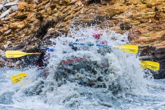
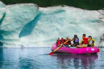
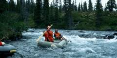
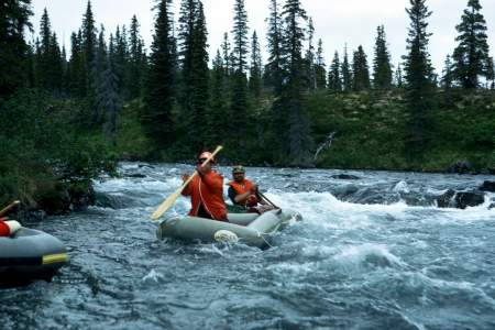
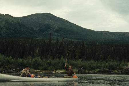
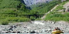
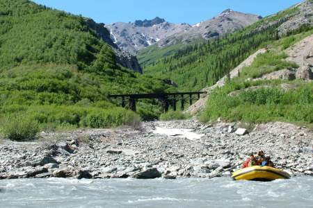
The Talkeetna River is a classic Alaska whitewater trip with Class IV – V rapids, fast canyons, and turquoise glacial water. It offers stunning Denali views, great hiking, fishing, and abundant wildlife. A bush plane is required for access, and jet boats crowd the lower reaches during King Salmon season. The 60-mile route takes 3 – 7 days and suits medium to large rafts or kayaks. Bears are common during the salmon run.
The Fortymile River, a Yukon tributary, flows through rugged terrain with Class I‑IV rapids. Known for its twisting route and blind turns, it has major rapids at The Kink and Canyon Rapids. The Taylor Highway provides multiple access points, with trips from 2 – 5 days. More remote sections require flying in. The area has a rich Athapaskan history, extensive mining, and federally designated Wild and Scenic River status.
The Chena River flows 50 miles from the White Mountains through Fairbanks. Fed by five tributaries, it is a Class II river with logjams, small channels, and campgrounds. The Middle Fork serves as the main section. The Chena Hot Springs Resort is a common starting point. With interesting features along its length, the river takes 5 to 7 days to complete.
The Charley River, a National Wild and Scenic waterway, flows 108 miles to the Yukon, passing through valleys, cliffs, and floodplains. It offers clear waters, hiking, and whitewater, with Class II-III rapids and occasional Class IV in high water. Rich in history, it has evidence of early occupants and gold mining relics. Most trips cover 88 miles in 6 – 10 days, making it a premier Alaskan wilderness adventure.
Beaver Creek National Wild and Scenic River has its headwaters in the White Mountains, north of Fairbanks, Alaska. The river flows west past the jagged limestone ridges of the White Mountains before flowing to the north and east, where it enters the Yukon Flats and joins the Yukon River. It is one of the few road accessible streams in Alaska with a Wild and Scenic designation. The first 127 miles of Beaver Creek were designated a National… ...more
The Chulitna River flows south from Broad Pass, offering a 75-mile float taking 3 – 5 days. The upper section is great for canoes and kayaks, while the lower is more challenging. The East and Middle Forks are popular mid to late summer, attracting floaters and anglers. As the West Fork joins, the river changes from a clear, rocky stream to a powerful glacial river with strong eddies and big holes.
The Nenana River, forming Denali National Park’s eastern boundary, is Alaska’s top rafting destination, offering various difficulty levels. A thriving industry provides 2‑hour to overnight trips. Kayakers enjoy its waters, including the annual Nenana Wildwater Race. Its Class IV gorge hosts wildlife like sheep and eagles. In 2012, extreme flooding tripled its flow, with guides navigating peak floodwaters after careful planning.
The Gulkana River is an 80-mile National Wild and Scenic River, popular for whitewater trips and fishing. It takes 5 – 7 days to paddle, starting with a 7‑mile stretch on Paxson Lake. Rapids range from Class I‑IV, with a fast, boulder-filled canyon (Class IV) that non-experts should portage. The river features King Salmon runs, scenic views, and a mix of slow and rocky waters, ideal for experienced paddlers.
The Happy River is a top-rated Alaska Range river, first floated in the last 20 years. It features swift, rocky rapids, stunning views, and parallels the Iditarod Trail. Flowing into the Skwentna River, it offers a 6 – 8 day journey through remote wilderness. Kayakers find it easy, but rafters face challenges. Cold, splashy waters require dry suits. Accessible only by air, it’s a true adventure.
The Chatanika River, a Class II stream in the Yukon River drainage, flows from the Alaska Range through valleys before reaching Minto Flats. Ideal for canoes and kayaks, it includes the 28-mile Chatanika River Canoe Trail, a BLM-registered route. The longest floatable section is 45 miles, taking 3 to 4 days. The river features clear or lightly tannic waters and offers a scenic wilderness experience.
The Yanert River, a hidden gem and the largest tributary of the Nenana, flows through a dramatic valley near Mt. Deborah. This 20-mile Class II river passes through a glacial outwash plain, a deep gorge, and rugged mountains before joining the Class III+ Nenana. Ideal for a 3 – 4 day trip, it offers great hiking and stunning scenery. Rafts are best, though kayakers complete it in two days.
There are gravel bars that a chartered plane with wheels can land on, or there are quiet, deep sections of river just below Victoria Creek that a floatplane can land on.
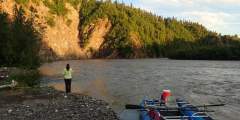
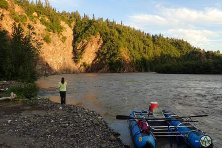
The best spot to put in is at Yellow Jacket Creek, about 20 miles from the Talkeetna Glacier, even though the gravel strip itself is not a favorite of some pilots. But groups do go there and it is where we recommend you go. By starting at this point you have good hiking in the upper alpine mountains.
The take out is normally the Chulitna Bridge of the Parks Highway at mile 132.8 and by this point the river is flowing big and getting pulled over and stopped can be tricky sometimes. But the left side of the river, just above the bridge, is the best access.
Expert Advice