Why Float This River
The Nenana River, a glacial river, forms the eastern boundary of Denali National Park and is possibly the most popular river rafting destination in the state. It offers a variety of levels of difficulty and has a thriving commercial rafting industry that operates 2 hour, 4 hour and overnight trips for locals as well as out of state tourists. It is also a favorite whitewater kayaking destination for boaters throughout the state and has an annual Nenana Wildwater and Slalom Race each Fourth of July. The Nenana River Gorge has 10 miles of solid Class IV whitewater within a steep-walled canyon that is home to wild sheep and nesting golden eagles, while it's headwaters are a beautiful wilderness area full of moose, bear, wolves and caribou, all within the setting of the rugged Alaska Range Mountains. It flows through an area within the 62 to 63 degree north latitude range. Usually fairly predictable, flooder waters during the fall of 2012 filled the river with 2-3 times its normal amount of water. One group of whitewater guides actually rafted the Nenana at its peak flood stage after days of scouting and extensive safety planning.
Put In & Take Out
One of the reasons the river is so popular is its access by road and every put in could also be a take out and it is discussed in that light.
Both the Denali Highway, Alaska State Highway #8, and the George Parks Highway, State Highway #3, offer good access in several locations. In general, the river begins mellow but becomes increasingly more difficult with distance down river until it morphs back to its mellow, former self.
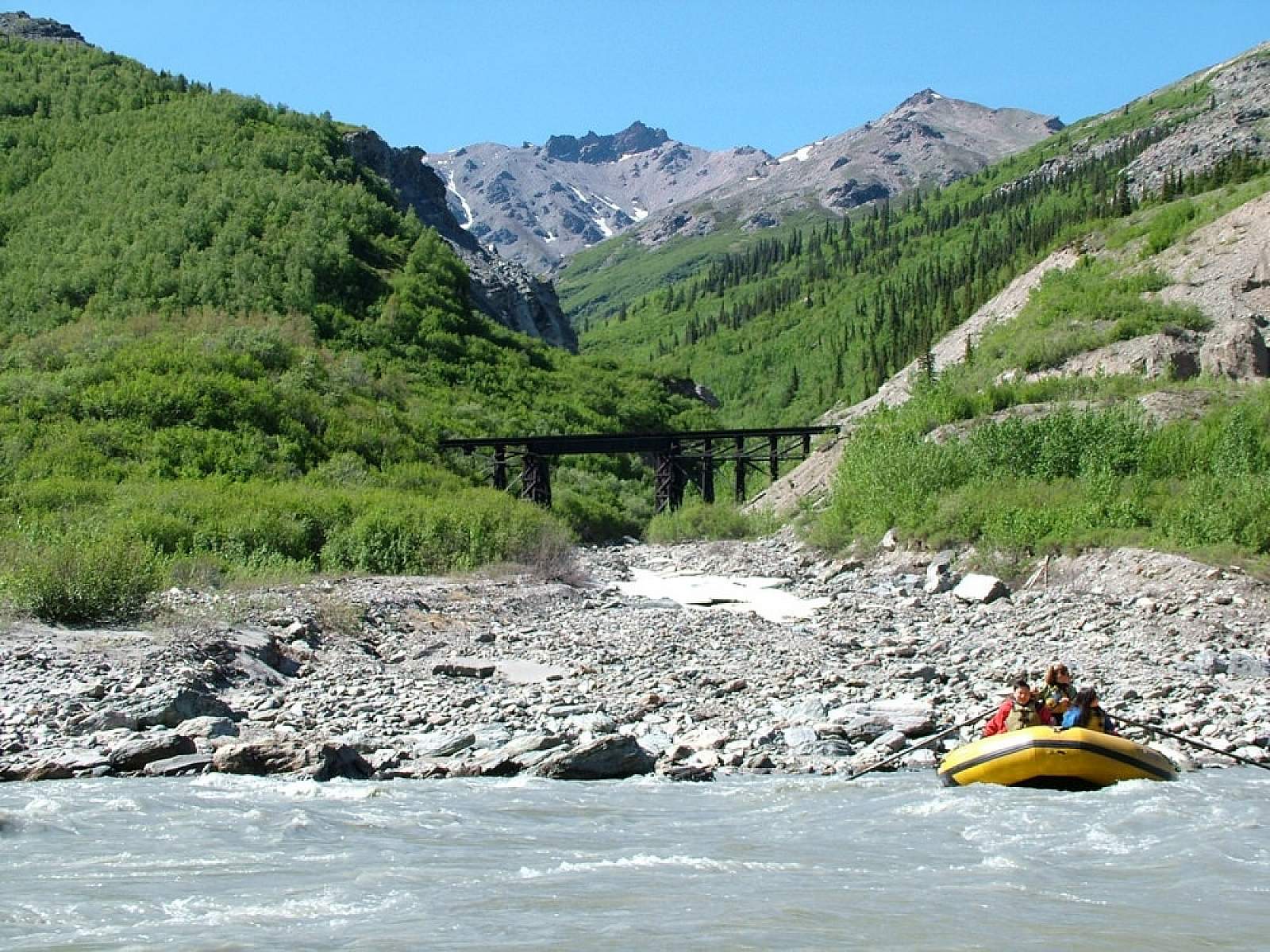
The upper reaches of the Nenana flow out of the Nenana Glacier and runs south then west into a wide glacial valley and the primary access for the upper Class II stretch is from the Denali Highway at mile 20. This is a geologically interesting area as the river runs into the trench of the Denali Fault Line, a major source of earthquakes and mountain building processes. Canoes and kayaks are well suited for this region and fishing is decent at the tributary confluences. From the Denali Highway the river cuts past the Reindeer Hills to its next access point at the Windy Bridge, just north of the town of Cantwell where the Parks Highway crosses the Nenana just above the confluence with the Jack River. Just below the highway bridge on river left is excellent access ending this 15-mile Class II stretch. It is here that the river bends to the north and escapes the Denali Fault Line where it picks up speed as it slices through some of the most rugged mountains in the Alaska Range. Six thousand foot peaks form the valley sides and the Denali National Park boundary begins on river left. The next 30-mile section is a popular stretch of river with several highway pullouts and bridges for access. It is Class II and III for 18 miles to the McKinley Village Bridge and Class III and III+, the 12 miles from Mckinley Village to the next highway bridge just below Riley Creek. From here to Healy is the Class IV+, experts only section that runs through the Nenana Gorge. Below this point the river becomes another wide valley river of Class III nature.
In general the river offers a great 1 or 2 night trip that starts easy and finishes with a bang. Campsites along the way are numerous in a beautiful wilderness even though a highway is not far from you.
The Trip
Mile 20 Put In to Windy Bridge: 15 miles
From the easy put in at Mile 20 a nice, but swift section of river runs west along a winding course. The put in is just below the confluence with Wells Creek. Further upriver is Brushkana Creek, where a few parties have started the run. Brushkana Creek is a 5- or 6-mile bony, bumpy creek run to where it joins the Nenana. There are several deep sections of river after the initial braided section below Mile 20 put in. Where the river bends more to the north and it starts to cut past the Reindeer Hills the river leaves the wider valley and enters a part of the Denali Fault Line trench and Brushkana Creek soon enters from river right. All along here are some narrow sections with blind turns. Be on the alert for occasional jet boat traffic that comes upriver carrying tourists to a river left launch site. If it is hunting season there might even be private jet boats coming upriver and there have been instances where canoes were tipped over by the wake from the fast moving boats. If you hear them coming, yield for your own sake. Eventually you will see where George Parks Highway Bridge, commonly called Windy Bridge, crosses the river as well as a set of power lines. Move over to the left if you plan on taking out at the launch site below the bridge.
Windy Bridge to Mile 220 Turnout: 8 miles
From Windy Bridge to the easy take out at Mile 220 of the Parks Highway is another swift section of Class II river with one Class III rapid where the river pushes right up to the base of the dramatic Panorama Mountain. Here the river then swings back to the west for a brief section to run just below the tracks of the Alaska Railroad. Soon the confluence with Sline Creek, incorrectly labeled Slime Creek on many maps, is passed on river right and after another 3 miles of easy Class II, the Mile 220 highway spot is reached.
Mile 220 to McKinley Village: 10 miles
From the access along the highway to McKinley Village is one of the most popular sections of river and is run by locals in canoes, kayaks and rafts all summer. It is a swift section with several long boulder garden type rapids, one ledge hole kayak play spot and high river bluffs. After a few easy miles, the confluence with Carlo Creek on river right is passed. It is easily noted by the homestead and by the large wind turbines that are here. This is private property and you are asked by the local family to not stop here. After Carlo Creek the river begins its run through boulder gardens, past the ledge hole and through one rapid called Ovary Crusher at the base of the river right sandstone bluffs. Soon the river makes an abrupt turn to the east and the Mckinley Village Bridge comes into view. Take out is on the right just after the bridge. It must be noted that at times of high water this stretch can be a very pushy Class III+.
McKinley Village to Jonesville Bridge: 10 miles
This is one of the stretches of river that supports the commercial rafting industry of the area and is a beautiful and more remote section of river. The river departs the highway and flows quickly down through numerous boulder gardens, big mid river holes and one dangerous recirculating river left ledge hole. From its start the river quickly goes through a big oxbow-like stretch followed by a strong narrow stretch with holes at the base of a big river right cliff. After this beginning, the river mellows out for 3 miles as it approaches the confluence with its biggest tributary, the Yanert River. The Yanert flows directly from the glaciers of Mt Deborah and as a result the Nenana gets instantly colder and stronger with much more sediment load. It is in the winding turn just before the confluence, where a ledge hole on river left, at certain water levels, has a recirculating nature and has caused several flips and a few deaths. Below the Yanert, the river is wide with no obstacles for 4 or 5 miles to its confluence with Montana Creek. All along the right are cliffs that are lambing areas for the resident population of Dall's Sheep. Where the river meets Montana Creek, quickly followed by Riley Creek on river left, is where the river picks up steam for a very swift and long section of pushy Class III. Terror Corner is the stretch at the base of the sediment cliff river right just after Riley Creek and for the next half mile there is a long series of big waves to hit and holes to miss. Immediately after is the Jonesville Bridge where the George Parks Highway, again, crosses the river. Access is on river left above or below the bridge or 200 yards around the corner at a public access below Kingfisher Creek on river right.
Jonesville Bridge to Healy: 12 miles
From the put in at the highway bridge or Kingfisher Creek begins the "for experts only" section of river that has more than a half dozen solid Class IV+ rapids at most water levels and when the river is at its highest all the rapids are capable of flipping 18 foot rafts filled with as many as 10 people, so extreme caution is needed. You should be sure to find out what the water level is before you cast off by contacting one of the commercial outfitters in the area. Dry suits or wetsuits are mandatory and at no time should hip waders be worn. Swims and flips are not uncommon on this stretch. Below the put in, the river parallels the highway for a bit where it goes through Razorback, Ice worm and Two Rocks rapids, and after these the river enters the steep walled Nenana River Gorge, where Cable Car, The Royal Flush, Coffee Grinder, the Knife, Train Wreck and the Narrows are churning the river into a maelstrom of froth. For many, the thrill is best achieved by joining a commercial group in a paddleboat or oar boat for the two hour run. It is a wonderful trip in the hands of a competent guide with Mt Healy and Sugarloaf Mountain forming the deep gorge. The last 2 miles of this section open into a wide braided river valley with seams of coal seen in the mountainside and a take out at the bridge of the Healy Spur Road, only four miles from the Parks Highway. Pull over river left immediately after the bridge and watch out for the train car wreckage, littering the river here.
Healy to Ferry: 15 miles
This is where the river morphs back to its old mellow self, passes the Golden Valley power plant and winds along with some holes to miss and channels to avoid, but is a quick afternoon float to the iron bridge that crosses at Ferry. The take out is not straightforward and you need to get stopped at the base of the bridge. Be careful as you come swiftly into the micro eddies there. A short carry up the bank will have you at the Ferry road that connects to the Parks Highway.
Ferry to Rex Bridge: 18 miles
From Ferry the river continues in a similar fashion through a maze of channels and forested islands past Moose Creek, Bear Creek and Birch Creek to where it reunites with the Parks Highway at the bridge take out. The best access seems to be on river left and you might stop early to see where to exactly pull in for derigging as there is a bridge building crew there these days preparing to replace the old iron bridge with a more modern style one.
Below this point the river is a mess of logjams and sweepers as it runs down past the town of Anderson, finally joining the big Tanana River at the town of Nenana.
Nenana River GPS Coordinates
Denali Park Highway Mile 20
The upper reaches of the Nenana flow out of the Nenana Glacier and runs south then west into a wide glacial valley and the primary access for the upper Class II stretch is from the Denali Highway at mile 20. This is a geologically interesting area as the river runs into the trench of the Denali Fault Line, a major source of earthquakes and mountain building processes. Canoes and kayaks are well suited for this region and fishing is decent at the tributary confluences. Put in option for Nenana River.
63.46247600, -148.81433500
George Parks Highway Mile 220
Put in/Take out Options for Nenana River
63.50087500, -148.81705300
Healy
There is a take out at the bridge of the Healy Spur Road, only four miles from the Parks Highway. Pull over river left immediately after the bridge and watch out for the train car wreckage, littering the river here. Put in/Take out option for Nenana River.
63.85423100, -148.95607700
Jonesville Bridge
Access is on river left above or below the bridge or 200 yards around the corner at a public access below Kingfisher Creek on river right. Put in/Take out option for Nenana River.
63.45672300, -148.80452200
Rex Bridge
The best access seems to be on river left and you might stop early to see where to exactly pull in for derigging as there is a bridge building crew there these days preparing to replace the old iron bridge with a more modern style one. Take out option for Nenana River.
64.21772000, -149.28091000
Windy Bridge
From the Denali Highway the river cuts past the Reindeer Hills to its next access point at the Windy Bridge, just north of the town of Cantwell where the Parks Highway crosses the Nenana just above the confluence with the Jack River. Just below the highway bridge on river left is excellent access ending this 15-mile Class II stretch. It is here that the river bends to the north and escapes the Denali Fault Line where it picks up speed as it slices through some of the most rugged mountains in the Alaska Range. Six thousand foot peaks form the valley sides and the Denali National Park boundary begins on river left. Put in/Take out option for Nenana River.
63.28800100, -148.06689300
USGS Maps
Fairbanks A-5, B-5, C-5
Healy B-3, B-4, C-4, D-4, D-5
Distance
8-88 miles
Days
1-4
Difficulty
Easy to Difficult
Class
I, II, III, IV
Craft
Kayak
Raft
Cost
$