Why Float This River
The Chena River begins in the White Mountains and is fed by five tributaries, the North Fork, South Fork, West Fork, Middle (East) Fork and the Little Chena. All the forks empty into the Middle Fork, which is the main section of the Chena River. The spring-fed Chena River runs right through downtown Fairbanks and is a Class II river with many interesting features along its length. There are some designated campgrounds in a few locations. In its upper reaches there are possible logjams you will encounter and smaller channels to avoid. At the end of the put in road is the Chena Hot Springs Resort, a likely spot to plan your start from. The entire river is about 50 miles in length and can be done in 5 to 7 days.
Put In & Take Out
There are numerous bridges and access points to the Chena all from the Chena Hot Springs Road and as a result numerous trip options are possible. The upper most put in is at the 4th bridge near Angel Creek and the Angel Rocks Trail. There are 3 other bridges within the Chena River State Recreation Area and three others in the downtown Fairbanks area. All could be either put ins or take outs.
The Trip
4th Bridge (MP 48.9) to 3rd Bridge (MP 44.0): 5 miles
The put in location of the 4th Bridge is also the Angel Rocks Trailhead. The North Fork of the Chena River is much narrower than the Main Fork down river. Floaters may expect many obstacles and hazards along this section. Lining or portaging your craft around logjams, shallows, sweepers, or other obstacles will likely be necessary. Mid- to late-summer floating is not recommended due to low water. Experience with technical river skills is advised.
3rd Bridge (MP 44.0) to 2nd Bridge (MP 39.5): 6 miles
A popular float starts on the narrower North Fork for a short way before joining the East Fork. Exercise caution shortly below the bridge as a logjam may require portaging. Hazardous water currents are frequently encountered at the confluence of the East Fork. Here the river widens with a brisk current and occasional riffles.
2nd Bridge (MP 39.5) to 1st Bridge (MP 37.8): 3 miles
Two options are available for takeout at this bridge. A road accesses a large gravel bar just above the bridge (across the highway from the campground), offering easy water access by vehicle. The bridge is visible from this gravel bar. Floaters may also take-out at the Granite Tors Trailhead at the bridge.
1st Bridge (MP 37.8) to Rosehip Campground: 10 miles
The river remains fairly easy going with many broad sections and narrower riffles. Expect many sweepers and floating hazards. Several river access points are available. Consult the map for locations.
Rosehip (MP 27.0) to Fairbanks: 31 miles
The gradient lessens closer to Fairbanks. Seven miles further is an access at Grange Hall Road but it is not obvious. No developed facilities are present on the north of the public access. Once past Rosehip you are leaving the Chena River State Rec Site and will enter the Tanana Valley State Forest with, to the south, Fort Wainwright Military Reservation. Nordale Road is the next easy access point, with vehicle access to the river just above the bridge. Several access points exist below Nordale Road into Fairbanks. The last easy access is at Pike’s Waterfront Landing after floating all the way through Fairbanks, where you can get food and drink. It is on left side of the river. Beyond this is the Tanana River.
Other Advice
- Camping: Floaters may camp along the Chena River within the recreation area. Please respect private land. Gravel bars make excellent camp locations, with breezes to help ward off insects. Note that gravel bars may flood during high water, often after rains. Camp above high water marks, and watch water levels. There are established campgrounds at the 2nd Bridge and at Rosehip access points. Please practice minimum impact camping. Pack out all garbage. Human waste should be buried at least 100 feet from water sources. This is bear country, so keep all food away from your camp. Confine fires to mineral soil, such as gravel bars, and extinguish them when leaving.
- Wildlife/Fish: Watch for king and chum salmon spawning in early August, and the grizzly and black bears that come to feed on them. Beavers are also abundant, and moose may be found foraging in backwater channels. Fishing is restricted to catch and release grayling fishing only.
- More Information: Further river information is available on some bulletin boards. Also, feel free to contact the Fairbanks office of Alaska State Parks.
Chena River GPS Coordinates
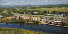
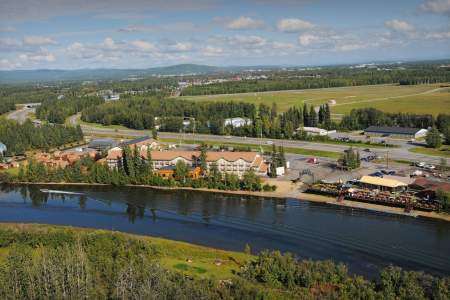
Pike's Waterfront Lodge
Family-run Pike’s Waterfront Lodge in Fairbanks offers comfortable accommodations, a view of the Chena River, gardens, and an inviting lobby. Pike’s Waterfront Lodge in Fairbanks sits along the banks of the beautiful Chena River. Inside, you’ll find comfortable accommodations; outside are beautiful gardens and a greenhouse growing lettuce, strawberries, and tomatoes. Dine inside, or out on the waterfront deck. The hotel also has Wi-fi, to help you stay connected while on vacation.
64.83094470, -147.84666000
Chena Hot Springs Rd: 4th Bridge
This is the uppermost put in for the Chena River. Put in option for Chena River.
64.94397800, -146.25219600
Chena Hot Springs Rd: 2nd Bridge
Put in/Take out option for Chena River.
64.89961300, -146.39051200
Chena Hot Springs Rd: 1st Bridge
Put in/Take out option for Chena River.
64.89757400, -146.41312800
Chena Hot Springs Rd: 3rd Bridge
Put in/Take out option for Chena River.
64.90190700, -146.36111500
USGS Maps
Circle A-5
Big Delta D-5, D-6
Fairbanks D-1, D-2
Distance
50 miles
Days
5-7
Difficulty
Moderate
Class
II
Craft
Canoe
Kayak
Raft
Cost
$