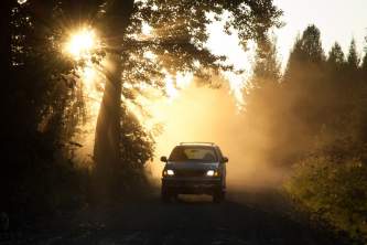
Anchorage to Valdez Driving Map
The drive from Anchorage to Valdez takes 6 to 7 hours on average. But, there are many scenic vistas and unique places to stop along the way making it easy to spend more than 6 hours on the road. You will have views of several mountain ranges, glaciers, and more. Below we have highlighted some of the best points of interest along the way.
Show Map
Driving Guide
Anchorage to Glennallen
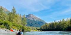
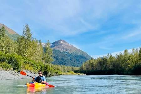
Whether it’s kayaking, canoeing, or paddleboarding, you’ll find top-flight equipment for rent at AK Paddlesports
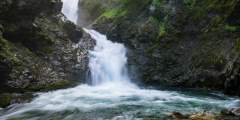
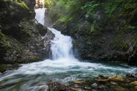
Who can say no to a cool waterfall only a half-hour’s drive from town? One of the most popular “first hikes” for families with small children, the one-mile trail to Thunderbird Falls traverses a handsome birch forest along the Eklutna River canyon to reach a deck with views of a 200-foot waterfall. During winter, the falls can freeze, forming fabulous columns of blue ice.
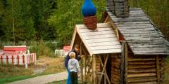
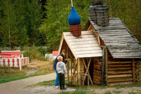
Dating back to 1650, the park is the area’s oldest continuously inhabited Athabaskan settlement. View the colorful Spirit Houses built over the graves of the deceased, along with an Orthodox Christian Cross — a custom that came from the melding of the cultures.

The campground is pretty open, since bark beetles killed the big, old spruce trees. The campsites attract RVers and campers, and each of the 24 sites has a fire ring and picnic table. There’s potable water at a hand pump.
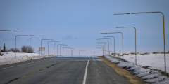
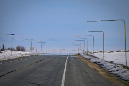
Looking to break up your drive with a jog or bike ride? This little-used, 2‑mile section of the former Glenn Highway has little to no traffic. Rocks and shrubs are creeping onto the road surface in places. It’s quiet, scenic, and hilly. The roadway is officially closed in the middle but easily-passable.
The Matanuska State Park is the best place for a free view of the Matanuska Glacier. You won’t be able to walk up to the glacier (that’s at Mile 102 and is $30 per person), but this well-developed site (wihch is also connected to the nearby RV Park) offers plenty of parking, public restrooms, and excellent glacier views and photo opportunities. You’ll also find: A half-dozen interpretive signs about glaciers, ice creatures, spruce bark… ...more
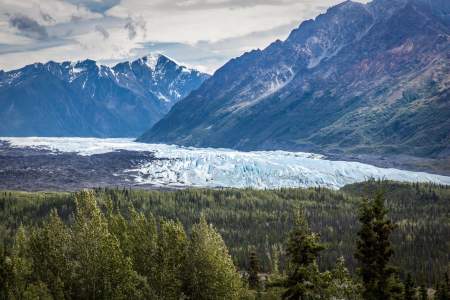
It’s only a small pull-out on the side of the highway, but this is the closest viewpoint of the Matanuska Glacier. If you don’t have a powerful zoom on your camera, or just want to get a great look at the ice, this is the spot. There’s only room for about six cars and the feel is a bit more rustic than the official state rec site a mile to the west, but you’ll be perched on a bluff overlooking the glacier. Distance 103.3 miles north of… ...more
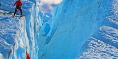
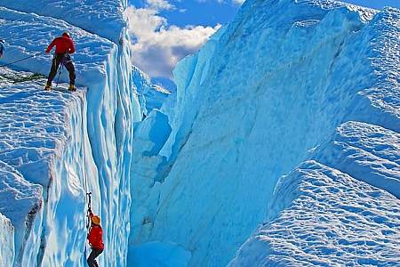
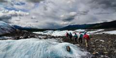
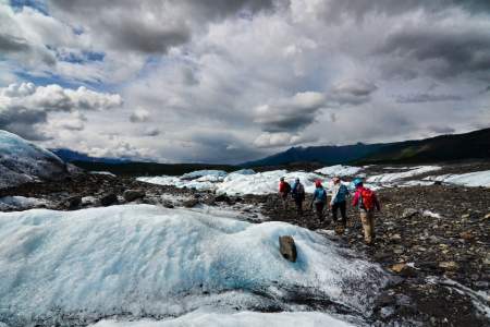
There’s climbing a mountain – and then there’s climbing an ICE mountain. Regardless of your climbing ability or experience, you’ll end the day feeling fulfilled and inspired. MICA also offers short, guided hikes and longer treks if you prefer a more leisurely explore of the glacier and its grandeur.
Lion’s Head is famous throughout the state. This rock outcropping is the prominent feature beside the Matanuska Glacier and is featured in magazines and advertisements all over Alaska. And you can hike it! You’ve got to be in good shape and ready for a scrambling, one-hour climb. You’ll be rewarded by great views, looking down a 2,000-foot cliff face to the glacier. You’re panorama will include views of the Matanuska River, Caribou Creek with… ...more
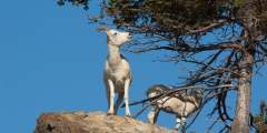
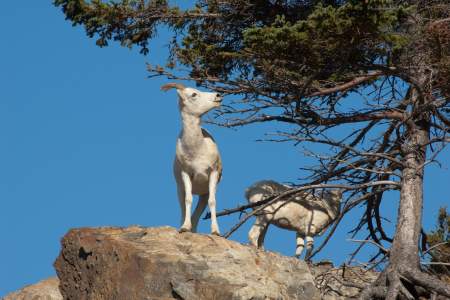
South-facing slopes can concentrate large numbers of sheep that are especially visible after green-up in the spring. Lodges in the area provide spotting scopes and good advice, and there are several pullouts and trailheads with safe parking.
People love to pull off here and shoot a photo beside this classic sign. A local theory on the creek name is that the crusty, old sourdough who lived down near the creek used mules for guiding hunts. These mules purportedly escaped a lot, so the asses were always by the creek. Who knows? But it’s a classic photo for the friends back home.
Just south of the Caribou Creek bridge near mile marker 104 on the Glenn Highway in the shadow of the Lion’s Head rock formation, look for the turnoff for the Caribou Creek Recreational Mining Area. You are not going to get fabulously rich here and be the next star of the TV reality show Gold Rush, but you do have the opportunity to carry a gold pan and shovel, hike the steep half-mile-long trail down to the creek, and pan for gold.
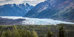
Some 15,000 years ago, this glacier reached another 50 miles west to the Palmer area. It now has a four-mile wide towering face that you can walk right up to and touch. Keep an eye out for summertime ice-climbers at this most impressive roadside glacier. Directions: Head north from Anchorage on the Glenn Highway. At mile 102, you can drive down to Glacier Park (888−253−4480), then hike 15 – 20 minutes to the face of glacier.Distance: 102 miles ...more
Climb to the summit of Belanger Pass, bike an all-day loop to Caribou Creek or off-road in a four-wheeler or ATV. This public access area is a gateway to adventure in the rolling tundra and alpine ridges of Belanger Pass and Syncline Mountain. The hike to the top of Belanger Pass is 90 minutes, following an old, rutted road. You can also bike this, following the Mining Road Trail for an all-day, 35 mile ride to Syncline Mountain and Caribou… ...more
This is one of Alaska’s premier recreation meccas. You’ll see lots of big-boy toys around Eureka Summit: RVs or big trucks pulling trailers with ATVs or brand new snow machines. This summit receives several feet of snow each winter, and rugged trails open access to the terrain during summer. Eureka Summit is the highest point along the Glenn Highway.
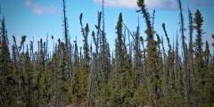
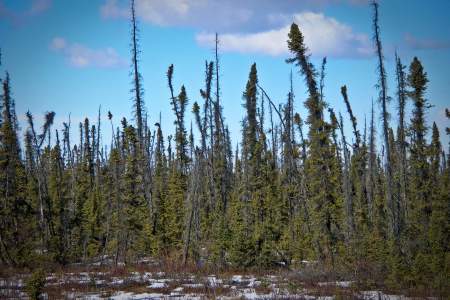
Even though black spruce forests look sickly, they’re actually healthy trees. Their shallow roots spread over permafrost, so they grow slowly. Soil above the permafrost melts and freezes, buckling the ground and making the trees tip. This stand might’ve sprouted around the same time as World War I, or even earlier. Maybe back when there were only ten miles of paved roads in the entire country.
Glennallen to Valdez
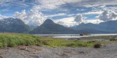
Just outside Glennallen you’ll find some great views of the Copper River and the Wrangell Mountains, as well as the chance to take some photos that don’t include any roads or buildings. Mt. Drum will be straight in front of you, with Mt. Sanford on the left side, and Mt. Wrangell— a massive shield volcano — on the right. Cloud cover is the only way you’ll miss this dramatic scene. And these mountains are definitely dramatic. The western… ...more
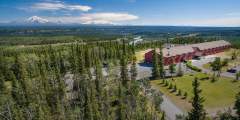
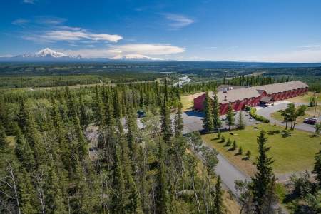
This intimate, 85-room lodge with amazing views is the perfect place to stay on the way to America’s largest national park, Wrangell-St. Elias. Look out your window to the junction of the Klutina and Copper Rivers, 200 acres of wilderness, and the park’s awe-inspiring mountains.

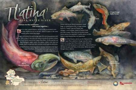
Historic Copper Center is one of the oldest non-native communities in Alaska’s Interior. Founded as a government agricultural experimental station, it later served as a transportation center for gold rush prospectors. Also find the interpretive sign where you’ll learn about the local fish species that make their home in different habitat niches of Copper River watershed creeks and rivers.
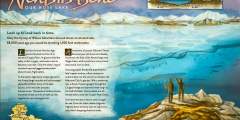
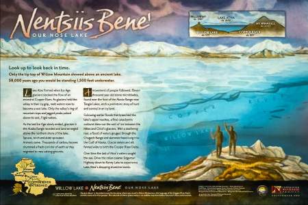
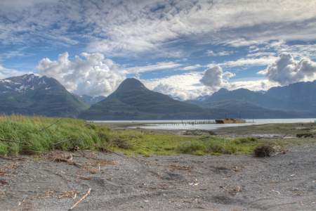
Traveling the Richardson Highway south of Glennallen, you will pass Willow Lake with spectacular views of the lake and the Wrangell Mountain volcanoes in the distance. Read about how ancient Lake Atna once filled the area you’re driving through and shaped the Copper River valley.
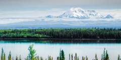
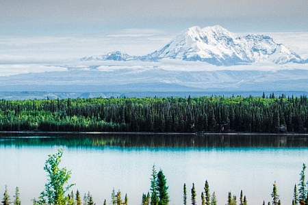
The mountain range you see at this point is over 50 miles away. Mt. Drum (12,010 ft.) is the nearest peak; Mt. Wrangell (14,163 ft.) is a semi-active volcano to the east; Mt. Sanford (16,237 ft.) is partly hidden and Mt. Blackburn (16,390 ft) is the tallest of the four major peaks. The Wrangell Range is over 5,000 square miles, and has 12 peaks above 10,000 ft. This is a great photo opportunity on a clear day, the mountain range reflects off… ...more
Pump Station No. 12. This is the last of 11 pump stations located along the Trans-Alaska Pipeline. There is no Pump Station No. 11. Only 6 pump stations are used to move oil today. These pumps move the oil through the 800 mile-long pipeline from Prudhoe Bay to Valdez. Most stations have three gas-turbine-driven mainline pumps. Each pump can move 22,000 gallons of oil a minute, that’s 754,000 barrels a day.
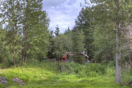
This one cabin is all that’s left of the old Tiekal Mountain Roadhouse (not to be confused with the Tiekal Lodge a few miles north.)
Alpine tundra often brings unimpeded views, easy walking, and an indescribable lightness of being. It also usually requires several hours of hiking to reach. But what if you could skip the exhausting hike and just drive there? The Thompson Pass is a great opportunity, rain or shine, to take advantage of easy access to this special environment — make the time for a stop. There are spots to pull over on either side of the road-cut that marks the… ...more
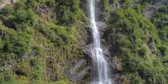
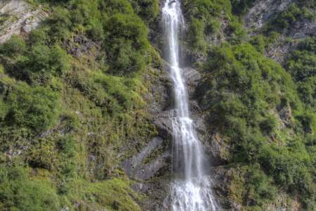
Bridal Veil Falls and the Valdez Goat Trail: This two-mile-long hike is a restored section of the Trans-Alaska Military Pack-train Trail that was the first glacier-free route from Valdez to the interior of Alaska. There’s a fantastic overlook about a mile down the trail.
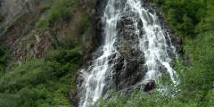
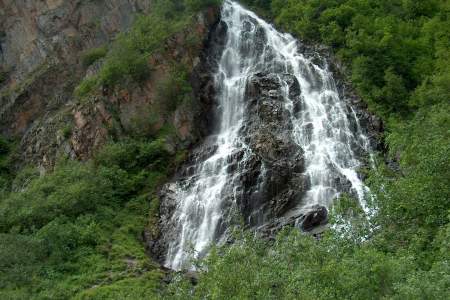
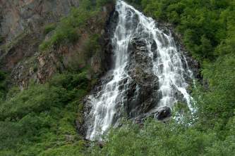
This picturesque fall is fed by snow and ice melt and empties into the Lowe River after flowing under the road. There is a roadside pullout next to the waterfall that provides easy viewing of the falls.
This was the original port and city of Valdez. The city was moved to its current location 4 miles down the road after it was devastated by the 1964 Good Friday Earthquake.
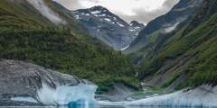
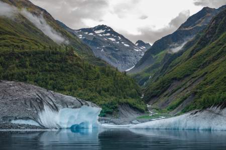
If you’ve yet to set eyes on an iceberg, this is your chance: Gorgeous Valdez Glacier Lake is often home to large chunks of floating ice that have calved off from the Valdez Glacier. Appreciate the chunks of ice from shore, or join a guided kayak expedition to paddle around the ice
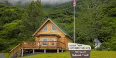
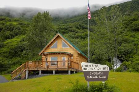
Operated by the U.S. Forest Service and open only in summertime, it’s staffed by guides who can help you understand the area. There’s also a stream that runs thick with pink and chum salmon when they return each summer to spawn. Thanks to a footbridge over the stream and the clear Alaskan water, it’s easy to see the fish. (The best viewing is from mid-July through October.) You may also see black bears, who come to feast on the fish.

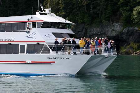
This family-run company operating out of Valdez will show you the best glaciers, with great customer service along the way. On any given day trip you’ll likely see huge rafts of sea otters, horned and tufted puffins, cormorants, humpback whales, or even bald eagles. Stan Stephens offers two daily tours, one of which features Columbia Glacier, the largest tidewater glacier in Southcentral Alaska.
The museum portrays the community’s unique and colorful history from European exploration in the 1700s to contemporary oil transportation. Permanent exhibits are accented by temporary exhibitions of arts and crafts. Major artifacts include a 19th century Fresnel Lighthouse Lens, a beautifully restored 1907 Ahrens “Continental” steam fire engine and a companion 1880s Gleason & Bailey hand-pumped fire engine, saltwater aquariums with the… ...more
Expert Advice