Nome Historic Park or Site
Nome is a paradise for the history lover. Its story is well-documented by artifacts, whether dug from the ground (in the case of ancient Native tools) or slowly sinking into it (in the case of gold rush era buildings and equipment). The people who live here are proud of their collective history and are more than welcome to share it with you.
What happened here, and what continues to happen here, is a blending of history and tradition that continually adds to the story of Nome.
Visiting these historic places, you might try to close your eyes and imagine them as they were in their prime. TheLast Train to Nowhere is rumbling off toward Council City. Russian soldiers are walking around the Satellite T-Hangar, preparing for the flight to World War II’s Eastern Front. And Old St. Joe’s cross is lit, guiding travelers, a warm beacon here on the remote edges of Alaska.
Show Map
Historic Park or Site

A visit to Nome and the Seward Peninsula brings you to the origins of the Americas’ indigenous populations. It was here that several great migrations took place from Asia to North America, across the Bering Land Bridge. The route was made possible by lowered sea levels, which exposed a land passage ranging up to 1,000 miles wide, linking what is now Russia to the Seward Peninsula of Alaska. ...more
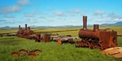
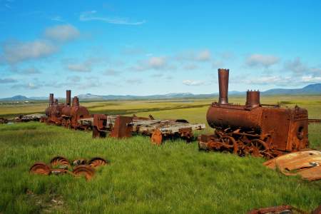
Just across Bonanza Bridge, three rusty steam locomotives and some rolling stock lie sinking into the water-logged tundra. Dubbed “The Last Train to Nowhere,” they are all that remain of a dream to build the most extensive and prosperous rail system on the Seward Peninsula. In the early 1900s, Chicago investors backed construction of the Council City & Solomon River Railroad in an effort to link the region’s major mining centers by rail. ...more
Railroad construction began in Nome the summer of 1900. By 1906 the track stretched 80 miles to the Kuzitrin River. Like many other residents, the world famous musher Leonhard Seppala ran his dog team along t he tracks using a small railroad car, called a “pupmobile.”
In 1904 a telephone line ran from Nome to the railroad terminus at Dickson, to the mining camps up Big Hurrah Creek, and on to Council. For one brief summer, parcels could be mailed to any point in the U.S. and money orders sent worldwide. The Council City & Solomon River Railroad also ran past, offering miners a one-hour trip to the coast. Grizzlies, moose, muskox, and reindeer are frequently sighted between the creek and East Fork Bridge. ...more
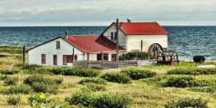
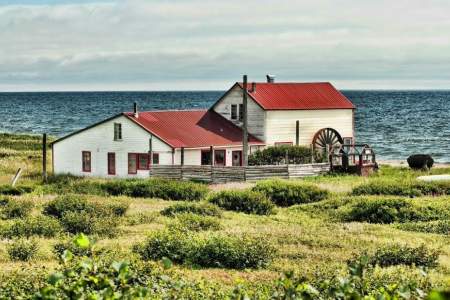
As you round Cape Nome, the Cape Nome Roadhouse is on the shore-side of the road. Road-houses once flourished along trails around the state, providing food and shelter for winter travelers who often arrived by dog team or horse-drawn sleigh. The Cape Nome Roadhouse also served as an orphanage after the devastating epidemics of the early 1900s and as a World War II communications base. It is now a privately-owned camp.
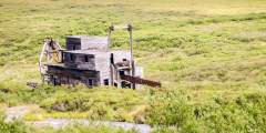
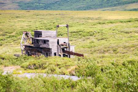
Miners worked this dredge up and down the Bluestone River and Gold Run Creek in the early 1900s. Now it serves as a nesting and perching site for common raven.
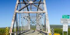
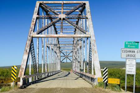
The Kuzitrin River Bridge had its origins in Fairbanks. It was originally named the Cushman Street Bridge when it was built across the Chena River in the heart of downtown Fairbanks in 1917. In the 1950s the bridge was replaced with a concrete span and the original metal bridge was disassembled, shipped down the Chena, Tanana, and Yukon rivers and barged up the Bering Sea coast to Nome. It was hauled in sections up the Nome-Taylor Highway and ...more
Historic site near Golovin opened by John Dexter where miners got their supplies and traded information. It’s where the “Three Lucky Swedes” stocked up (on supplies and help) after their big gold discovery on Anvil Creek in 1898. Also where Leonhard Seppala finished his long leg of the 1925 diptheria serum run. This building is still standing in Golovin, and was reportedly boarded up as is, with all its artifacts still inside.
Alaska has served an important role in U.S. military strategy, especially during World War II, and the Cold War. But the military history in Nome actually started even before the city was incorporated, when gold rush dealings and a population boom required some old fashioned law and order brought by U.S. soldiers.
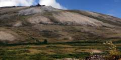
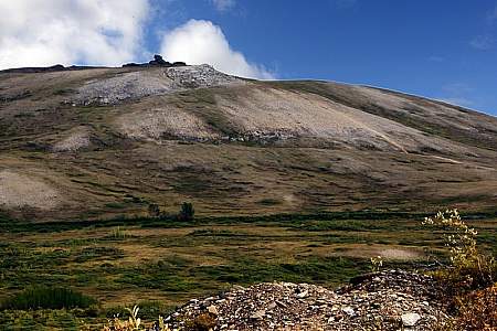
King Mountain is the next hillside on the west side of the valley where it is easy to see the multiple cuts across its slopes for much of the year. Most cuts are manmade ditches that once brought water to Nome’s gold fields for hydraulic mining operations.
“Nomehenge,” as some of the locals call the four towering antennas on Anvil Mountain above Nome, operated during the height of the Cold War to link remote parts of Alaska with the rest of the country. These are the last of 71 White Alice structures, and serve as important historic and geographic landmarks in Nome.
Beyond the bridge, a long line of small buildings hugs the coast where a U.S. Army post once stood during the early gold rush. Fort Davis was dismantled in 1923 as Nome’s economy declined. The buildings you see today are locally-owned hunting and fishing subsistence camps. The Inupiat used this area well before the soldiers arrived because of diverse and abundant birds, fish, and mammals. Please do not disturb or trespass.
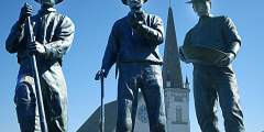
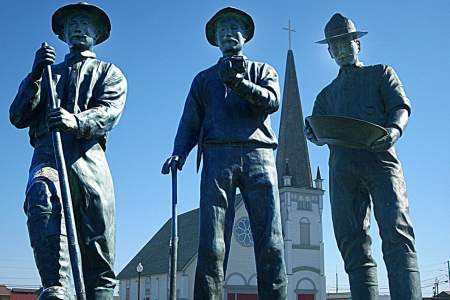
Three Scandinavians found gold in Anvil Creek in 1898 and quickly staked their claims. The fact that they knew little about mining didn’t impede their quick path toward wealth. Locals call them the “Three Lucky Swedes,” and their life-sized bronze statues stand in Anvil City Square, near where their lives were forever changed.
Beyond the Pilgrim River Bridge, the road continues uphill and offers sweeping views of a network of lakes and the meandering river valley. North of the Pilgrim River drainage is a large hill topped with a series of granite rock outcroppings known as Hen and Chickens because of its resemblance to a small flock at certain angles. A cross was placed at the summit in memory of a priest who died in a blizzard on his way to the orphanage.
Many locations around Nome are named after John Dexter, a miner and businessman who opened an important early trading post/roadhouse in Golovin. Two other roadhouse/bars have also carried the Dexter name, which can get confusing for visitors. Read our descriptions to help sort them out.
Russian soldiers were a common sight around Nome during World War II. The government’s top secret Lend-Lease program provided Russia with critical war materials to aid the fight against Germany, and Nome was the last fuel stop for war planes headed West. A 1944-era hangar can be seen here today, a relic from this amazing effort.
Teller Road crosses Anvil Creek one mile below the site of the 1898 gold discovery that triggered the Nome gold rush. From here you can view the wind turbines that form the start of Nome’s efforts to harvest wind as an alternative energy source.
Beginning in the summer of 1899, thousands of men, women, and children worked shoulder-to-shoulder to glean treasure from these shores after news of Nome’s “Golden Beaches” rocketed around the world. To this day, hearty independent miners continue to work many area beaches with high bankers and sluice boxes. Most find themselves braving the cold waters in wetsuits to operate small, modern, floating suction dredges essentially vacuuming ...more
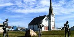
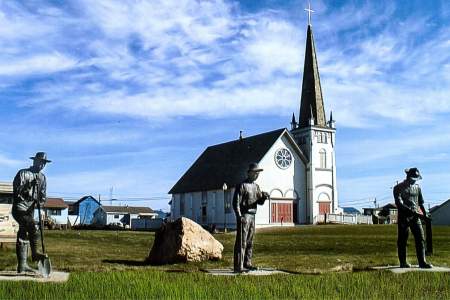
Nome’s Old St. Joe’s avoided the fate of many other gold rush era buildings, which were destroyed by fire or flood. Today it is restored and listed on the National Register of Historic Places. The story of Old St. Joe’s parallels that of the Alaskan pioneer spirit: one of hard work, resourcefulness and a deep respect for the past.