Portage Glacier, Portage Valley & Whittier Tunnel Drive Guide
Portage Valley southeast of Anchorage at the head of Turnagain Arm offers so many potential adventures that you might have to tow a trailer loaded with gear to sample them all. What will you find here? Biking, hiking, picnicking, fishing, paddling, wildlife viewing, potential iceberg sightings — plus a natural history visitor center packed with interactive displays about the ecosystem of the valley and Prince William Sound. It’s like an outdoor Disneyland just over an hour’s drive from town.
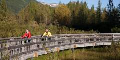
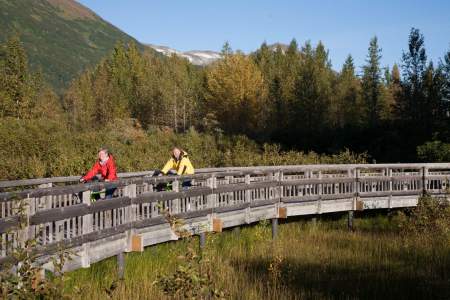
Trail of Blue Ice
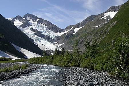
A highlight may be the five-mile-long Trail of Blue Ice, a biking and hiking route that starts at the Moose Flats Day Use Area and connects to most of the developed stops along the road before reaching the lakefront by the visitor center. Almost completely flat, the trail winds through the forest and crosses wet areas on handsome boardwalks. It is very popular destination for family biking, with one highway crossing.
Explore the ponds
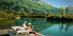
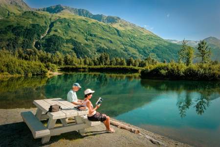
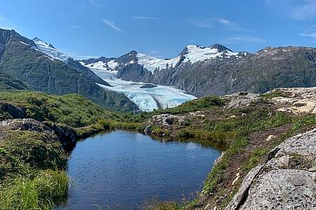
Want to paddle around? Several interesting-but-calm lakes with relatively warm water can be accessed from pullouts along the road. Try the system of ponds and channels at the entrance to Alder Pond (stocked annually with rainbow trout) about 1.5 miles from the Seward Highway. For those with more advanced skills, float or canoe Portage Creek, considered the least gnarly whitewater trip in the Anchorage area.
Gold Rush route
A portion of the north shore of Portage Lake is also open to paddling to the beach below Portage Pass. This water trail parallels the route that Native Alaskans and gold-rush prospectors once traveled between Prince William Sound and Turnagain Arm before the glacier retreated. (The rest of the lake is closed to paddling.) The launch spot is at the parking area just past the first highway tunnel. Be prepared for very cold water, unexpected winds and rough conditions.
Getting there:
From Anchorage, take the Seward Highway south to the head of Turnagain Arm. The turn-off to Portage Valley is 48 miles south, just past the Alaska Railroad staging area and the bridges over Portage Creek. Portage Lake and the Begich Boggs Visitor Center are about five miles to the east. Here's information on the area from the USFS.
Weather note:
When it’s sunny and/or calm, Portage Valley may be one of the most stunning — and welcoming — destinations in the region. But check the forecast and weather cam! The valley can sometimes get quite stormy, with high winds and sideways rain. Here's the Real time road weather at Portage Valley Road intersection with Seward Highway
Show Map
Portage Valley Driving Guide
Portage Valley Highway
Located at Mile 1.0 of the Portage Highway, this site has a short boardwalk trail along several ponds. It is a good site for observing waterfowl that nest and rear their young in the ponds and river channels.
This beautiful 5‑mile trail begins at Moose Flats Recreation Area and winds through forests, wetlands, streams, and glacial landscapes on its way to Portage Lake. Along the route, hikers enjoy stunning views of mountains, hanging glaciers, and evidence of the glacier that once filled the valley. The trail ends near the lake shore, offering panoramic views and a chance to experience the dramatic changes that have shaped this iconic Alaskan ...more

Stop at the turnout to photograph this beautiful hanging glacier high on the mountainside.
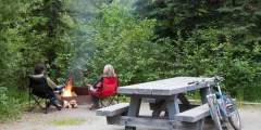
Biking, fish viewing, a natural history center and a flat hike to a glacier are within easy reach of this quiet, intimate campground in Portage Valley at the head of Turnagain Arm in the Chugach National Forest. The 12 sites in the graveled, wooded Black Bear are yards from the Trail of Blue Ice — a non-motorized multi-use trail that traverses the valley floor.
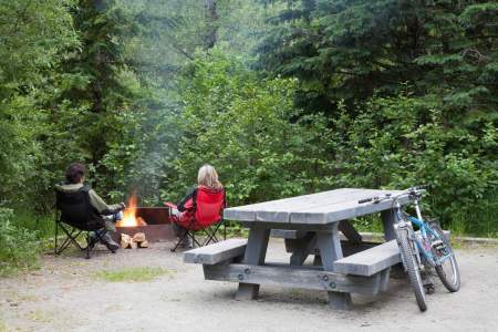
With 60 sites on paved loops, Williwaw is suitable for large motorhomes and offers great access to the Trail of Blue Ice — a non-motorized multi-use trail that traverses the valley floor. Also nearby biking, salmon viewing, hikes, and glacier viewing.
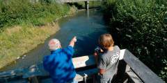
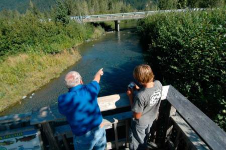
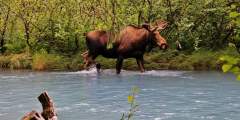
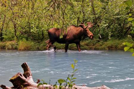
Crystal-clear Williwaw Creek and its bank-side trail system in Portage Valley at the head of Turnagain Arm offers exceptionally good conditions for watching spawning in action. Coho, sockeye and chum salmon converge on the creek as it winds through the brushy flats beginning in mid-August, with some late-arriving fish still present after first frost in the fall.
There is a good guide for this trail available at the Begich, Boggs Visitor Center at Portage Glacier. Numbered trail posts correspond to things in the guide. This is a great place to view spawning salmon in the fall. It is a well-maintained path with a thirty-foot bridge. This hike is wheelchair accessible and there are lots of berries and various wildlife species.
Portage Lake Loop

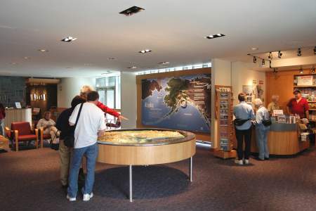
Why go The Forest Service’s Begich, Boggs Visitor Center is located in Portage Valley, one of Alaska’s most visited recreation areas. The valley is a showcase of glacial activity with a number of “hanging” glaciers gracing the encircling mountains. The visitor center is located on the northwestern shore of Portage Lake, and was built on the terminal moraine left behind by Portage Glacier almost a century ago. The Trail of Blue Ice, Byron… ...more
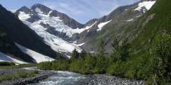
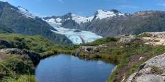
This short day hike — with an easily accessible trailhead a few hundred meters from the Begich Boggs Visitor Center — offers you big views of the Byron Glacier.
Originally built in 1956 as a bar at the end of a 5 mile gravel road which served Glacier Ice Margaritas. In 1964 a restaurant and lodging was added, but the lodging portion was eliminated in 1980. The only place to eat in the valley, this family-run day lodge has a gift shop and serves cafeteria-style food.
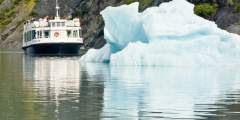
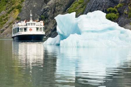
Just an hour’s drive from Anchorage, the MV Ptarmigan let you get within 300 feet of the towering ice wall called Portage Glacier. You can also book a narrated motorcoach tour to take you to Portage Glacier.
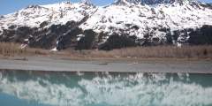
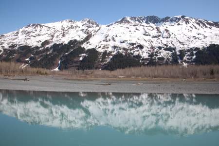
Deep enough to submerge an 80-story building, the lake was carved out over thousands of years of glacial advances. While Salmon make their way into the lake, you may not see them due to the immense deposits of glacial silt. The silt also protects them from predators such as birds and larger fish. However, they eventually make their way to clearer waters. Look for dense blue icebergs from Portage Glacier blown to shore.
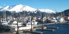
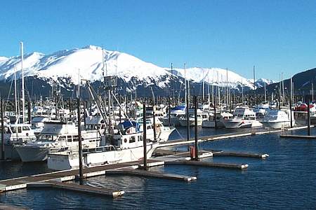
Bear Valley, Whittier Tunnel & Whittier
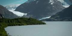
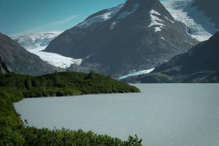
It’s free to go this far by car, and you’ll get a picture-perfect shot of Portage Glacier.
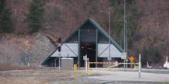
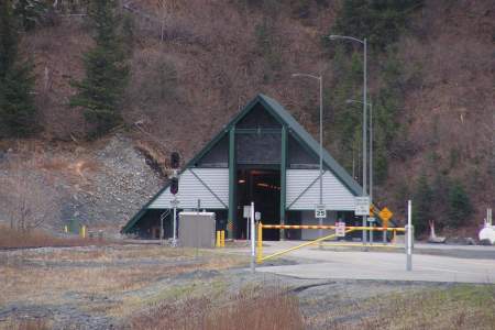
Driving from Anchorage to Whittier to play in Prince William Sound? You’ll go through Anton Anderson Memorial Tunnel — the longest (2.5 miles) highway tunnel in North America, and the first designed for ‑40 Fahrenheit temperatures and 150 mph winds! The one-lane tunnel must be shared by cars and trains traveling in both directions, and it usually needs to be aired out in between trips (with jet turbine ventilation, another first!). This unique… ...more
This 2‑mile-long, family-friendly trail, which begins 90 minutes south of Anchorage at the far end of the Whittier Tunnel, remains the only easy way to see Portage Glacier on foot. And it’s has a spectacular conclusion: After cresting Portage Pass, the trail drops through glacial scrub before popping out on the wide gravel shores of Portage Lake, directly across from the snout of gorgeous Portage Glacier.