Denali National Park Points of Interest
Show Map
Points of Interest
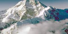
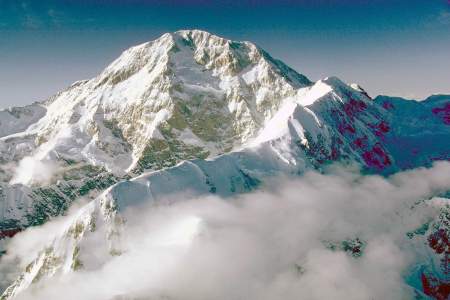
36 miles west of Denali (Mt. McKinley), Mt. Russell is one of the major peaks of the Alaska Range — and one of the most dramatic. To give a sense for its size and steepness, it rises over a vertical mile above the Chedotlothna Glacier to the northwest in less than two miles. It rises two miles above the Yentna Glacier to the south in only 8 miles. Overshadowed by its massive neighbors, only six ascents of the peak had been recorded by 2001.… ...more

Denali’s glaciers are high in the mountains of The Alaska Range. Here are the most impressive, and the flight tours to see them!
It’s 92 miles and about 5 hours from the park entrance to Kantishna, the end of the Park Road. Private vehicles aren’t permitted after Mile 15, so you’ll need to take either the hop-on, hop-off park shuttle bus or one of the tour buses. This road is only open in the summer months between May and early September. Dates vary depending on annual snowfall.
People visit Denali National Park for two main reasons: to see Denali (Mt. McKinley) and to view wildlife. While neither experience is guaranteed, your odds of seeing wildlife are good if you know where to look. Here are the top spots to see bears, wolves, birds, and more.
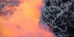
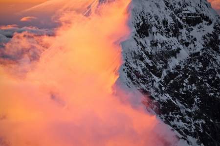
Soaring high at 20,310 feet is Denali (formerly named Mt. McKinley after an Ohio Senator who never visited Alaska). The mountain was renamed Denali in 2015. Equally impressive are its nearby cousins: Mt. Foraker (17,400), and Mt. Hunter (14,573). These three dominate the skyline for hundreds of miles. You can get up close and personal with the “Roof of North America” on a flightseeing tour. Up here, you are surrounded by ridges and peaks,… ...more
Denali National Park is full of rivers, with many of them originating from glaciers. What makes these rivers special? Why are they braided and what keeps them from just straightening out?
Harry Karstens was the first ranger of Denali National Park. He arrived in early summer 1921, and established his headquarters on the northwest bank of Riley Creek, an ideal spot for monitoring visitors using the trail leading into the park. In 1925, the headquarters moved to it’s current location at mile 3.4 of the Denali Park Road.
Beavers can often be seen here, usually early in the morning or later at night. The Park Service provides picnic tables and toilets on the south side of the road just after you cross the bridge. Stay as long as you like during the day, but no camping is allowed in the immediate area.
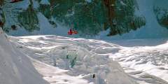
You enter the Sheldon Amphitheatre, named after a bush pilot who built a viewing hut here on the glacier before it became a national park. You can stay here for $100 a night. It has a wood stove and bunks 6. If you opt for a glacier landing, this is where you’ll likely land. You’ll step out of the plane and onto an ice sheet nearly a mile thick. The scale of the Amphitheatre is hard to fathom. You’ll feel like you can reach and out touch the… ...more
If you choose an “Around the Mountain Tour” (circumnavigates the mountain), you’ll ascend over the top of the Kahiltna Glacier and on to the north side of the Alaska Range. Look to the right, and you’ll see the 14-mile-wide Wickersham Wall. From the peak it’s 17,000 feet down, one of the greatest unobstructed vertical drops in the world. Considered a death route, the Wickersham has been climbed only a few times. A Romanian ski instructor skied… ...more
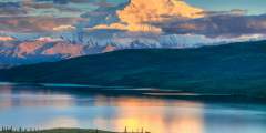
Wonder Lake is a somewhat unlikely lake. Learn how the lake was formed, and what makes it so unique.
Cross the Tokositna River which marks the southeast corner of Denali National Park. Look for tents or rafts next to the river. While difficult to access — even by bush plane — this area is a prime place for camping, exploring, and to begin a raft trip down the Tokositna River to Talkeetna. Out the left window, you can look south to the Peters & Dutch Hills, an active gold-mining area since the early 1900s. A winter wagon road from Talkeetna… ...more
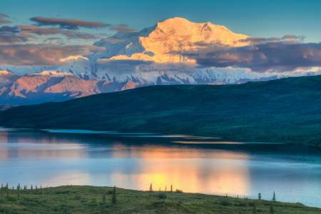
Once you leave the Wonder Lake campground, you’ll pass the aptly named Reflection Pond as the road begins its descent towards the north. From here you can get fantastic photos of both Denali (Mt. McKinley) and Foraker reflecting off the surface of the pond, especially early and late in the day when the water is the smoothest.
Not far from the Toklat River Bridge you’ll find yourself at the top of Highway Pass, the highest point on the park road at 3,980 feet. The vistas are expansive and wildlife viewing can be great.

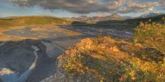
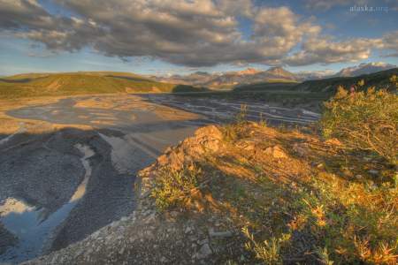
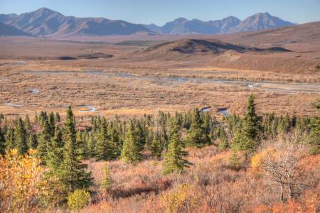
The Savage River was carved out by glaciers, and as a consequence it is a perfect example of a braided river. The flat gravel bars of the river offer a great opportunity for an easy hike, and minimize the chance of surprising a bear or other wildlife.
Spindly spruce trees lean this way and that, looking as if they’re drunk. The actual cause of this odd alignment has to do with their shallow root systems, which get readjusted by the nearly continuous expansion and contraction of permafrost under the tundra surface. Permafrost is a layer of frozen ground, sometimes more than 6 feet thick, that never thaws. Without it, much of the tundra would be completely impassable.
On a clear day, this stretch of the park road offers unparalleled views of Denali and the other high granitic peaks of the central Alaska Range. What role do glaciers play in carving out the ever growing shape of this mountain range? Audio tour by Camp Denali Wilderness Lodge.
An iron bridge crosses Moose Creek here. If you take a moment to observe the creek you’ll notice that the rushing waters are clear and full of grayling, quite the opposite of glacial fed waterways that appear milky due to the high sediment content.
The Denali National Park Visitors Center is actually more of a campus. The center itself is the main National Park Service welcome and information center and it is surrounded by other facilities that include a restaurant, bookstore/giftshop, bag check, bus stop and the Alaska Railroad depot.
The Alaska Railroad was responsible for opening this national park to the public since it provided the only access to the park for many years. The Railroad owned and operated the McKinley Park Hotel from its early beginnings and eventually turned over to the National Park Service for operations. After a fire destroyed the hotel, rail sleeper cars provided a novel lodging opportunity for visitors.
At the Wilderness Access Center, you can purchase bus tickets and all park shuttle buses depart from this building. This is also the place to reserve a spot in the various park campgrounds. Additionally, inside you will also find a gift shop, coffee stand, and an information desk.
Here is the junction of the Parks and the Denali Highway. The Denali Highway is approximately 135 miles long stretching from Paxson to Cantwell, connecting the Richardson and Parks highways. Before the Parks Highway was completed in the early 1970s, the Denali Highway was the only road access to Denali National Park.
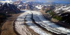
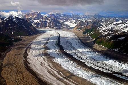
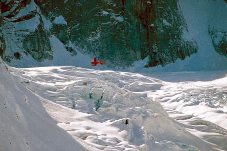
Flying down the medial moraine of the Ruth Glacier is mesmerizing. This 25 – 50 foot high ridge of rock debris looks like an excavation pit that extends for miles down the center of the glacier. Keep on the lookout for deep blue pools of ice melt. Look for lateral moraines on the sides of the glacier and the terminal moraine at the toe of the glacier… You’ll know the terminus of the Ruth when you see it: the contortions of earth and ice resemble… ...more
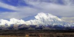
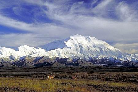
Last view of Denali during first few miles of Denali Park Road
It isn’t until you actually drive past the headquarters area that you will begin to enter the wilderness for which you have really come. During the winter months, the road is closed at this point. Only non-motorized travelers, such as mushers and skiers can go further. This is taiga forest, filled with white spruce and black spruce, interspersed here and there with quaking aspen, paper birch, balsam poplar and tamarack. This is moose habitat… ...more
Vegetation cover in Denali is always changing. Find out why the forests around the Toklat River are changing, and how the Park Service uses historic photos to document these changes. Audio tour by Camp Denali Wilderness Lodge.
Although most viewpoints along the Park Road can only be accessed by private tour buses or park shuttle buses, you can drive to this viewpoint (the first 15 miles are open to private vehicles). The dense spruce forest opens up here, giving you the first view of Denali, as it is called in the native Athabaskan language (formerly Mt. McKinley). The mountain is roughly 72 miles away and you’re only seeing the top 8,000 feet or so. Still, it’s a ...more
The fall moose rut is an unforgettable part of the interior Alaska fall. In Denali, the Eielson visitor center gives visitors a year round window into this dramatic event through the display of two sets of interlocked moose antlers. How did these antlers become locked, and what likely happened to the two unlucky bull moose? Audio tour by Camp Denali Wilderness Lodge. ...more
Denali Ranger Kris Fister, a 30-year veteran of the National Park Service, and a Camp Denali Lodge naturalist share some fascinating stories and things to look for along the Denali Park Road.
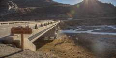
This sectioned bridge sits at an elevation of 2,655 feet. Park at the rest stop a few hundred meters before the east edge of the bridge for great views of the structure and the surrounding area.
You’ll traverse the spine of the north side of the Alaska Range for about 15 minutes, then fly through a mountain pass known as the Tralieka Col, back to the south side of the range. You’ll pass by the foreboding East Face of Denali (its only major unclimbed face) and descend down the West Fork of the Ruth Glacier. Look for pyramid-shaped Mt. Huntington off the right window, thought by many to be the most picturesque peak in North America.… ...more