Anton Larsen Bay Road
Heading southwest out of town and then curving towards the north, this relatively short road offers access to salmon streams, wildlife habitat, hiking, winter recreation, the Coast Guard golf course, and a protected bay that’s great for sea kayaking and beachcombing. Much of the road is above treeline, so you’ll have great views and panoramic photo opportunities, as well as easy hikes to the alpine. The road cuts north from Rezanof Drive just after Buskin River and Beach at Buskin River Bridge #7. Wet your line at this famous salmon stream, with sockeye salmon crowding the river on their return to Buskin Lake. The beach is a good spot to watch incoming planes, since it’s under the flight path for the airport. There’s also ranching out this road, so watch for cattle, in addition to fox, deer, and other wildlife. Start at mile 4.7 on Rezanof Drive West.
Show Map
Scenic Drive Points
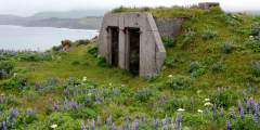
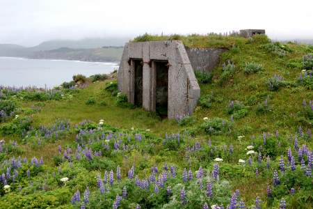
This was the largest base on Kodiak Island during WWII, and the center of the Harbor Defenses for Kodiak. At the peak, some 8,000 troops were stationed here. Now all that remains are some unmarked buildings.

The mountain range to the right is Devil’s Prongs and Barometer Mountain is to the left.
Open from May to September, this is the only golf course on the island. This nine-hole course features a full service pro shop and driving range; it’s operated by the U.S. Coast Guard but open to public. The course opens early and closes “two hours before sunset,” which means you’ll have the opportunity for some late rounds during summer solstice! http://www.kodiakmwr.com/golf.shtml
MP 3.2, Anton Larsen Bay Rd
Cross Fox Lakes on Kodiak Island are an excellent destination for a family outing, picnic, or swim on a hot summer day. You can continue past the lakes and explore the terrain farther up the valley. In winter, the lakes are a great place for ice skating.
This is the highest mountain close to town. If you tackle this hike, you’re in for a climb, but a large portion of the trail is in the alpine, with beautiful flowers and tundra. You’ll be climbing 2,400 feet in elevation in just two miles. Watch for upland birds including Willow and Rock Ptarmigan, and American Pipits.
Hike these scenic ridges and lush meadows
Watch for cattle as you drive through open range. You can admire the views from the bridge, or take the trail up Sharatin Cirque & Mountain and explore flowery slopes and signs of wildlife, including Mountain Goats, Pipits, and Ptarmigan.
This trail can be hard to follow as it meanders through wet areas, thick vegetaion and up salmonberry slopes before it reaches the rich subalpine meadows and eventually leads into a bowl-shaped glacial cirque at the base of the mountain. There is plenty of great bird habitat along the trail so watch for pipits and ptarmigan up high and songbird and snipe in the lower elevations.
This scenic, tranquil bay is a great place to access the water (there’s a boat launch) and to start hikes. You can hike to a beaver dam from a turnoff on the right at MP 11.6. Look for the white granite in the cliffs; this is the “backbone” of the geology here, the rock that the island is formed upon. From the end of the road, there is good hiking to a waterfall. To the right is a 2.5‑mile trail to Cascade Lake. You’ll have to cross the Red… ...more