Show Map
Points of Eagle Beach State Recreation Site
1
Difficulty: Easy
Distance: 7 miles
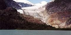
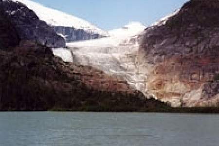
Relatively easy but long (up to 7 hours), this full-day hike is worth the effort for the views at the end. You’ll want to have good shoes and watch your footing, as the trail is lined with roots and is often wet. The trail winds through old-growth forest, past beaver dams and old mining rails, and ends at a log cabin nestled at the edge of a scenic lake with gorgeous views of Eagle Glacier and the surrounding mountains.
2

This short trail leads you along the mouth of the Eagle River and a salt marsh estuary. Be sure to pack a picnic as there are tables near the end of the trail.
3
Difficulty: Easy
Enjoy hiking, camping, & picnicking on this remote beach, known as Surfer’s Beach. The beach is accessible via a trail at MP 12.5 Pasagshak Rd.
4
Winding through old-growth forest, this trail is maintained for hiking year-round and cross-country skiing when there is enough snow.
5
Experience a number of different ecosystems along this trail. You’ll walk through open meadow, wetland, and rainforest muskeg just to name a few. You’ll also find beautiful flowers in the spring and juicy berries in the summer and early fall. Distance 1.8 miles Type Loop Features Wheelchair Accessible
6
Difficulty: Moderate
Distance: 6 miles
This trail follows the former mining tramway. The bridges are in poor condition and the trail has not been maintained in years. The area is very scenic with high populations of brown bears. The trail ends in Yankee Basin and connects to Bessie Creek Trail.