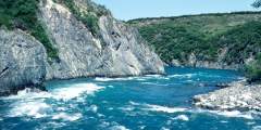
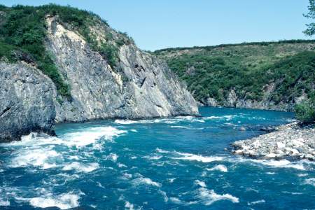
Issuing out of the aquamarine waters of Twin Lakes, the Chilikadrotna River, a Wild and Scenic River, flows past the high peaks of Lake Clark National Park and Preserve and speeds the 60 miles to its confluence with the Mulchatna River. The river runs an average of 5 miles an hour through birch and spruce forest with the jagged peaks of the southern Alaska Range standing above it. It can be run in as little as 4 days but a longer trip is recommended. The main obstacles are the occasional sweeper on the lower section of river. It is one of the rivers of the state given Wild and Scenic River designation and is a favorite destination for fly-in fishermen from nearby lodges. If not for this fact the river would be a lot more pristine. However the river has continuous swift water and long stretches of exciting rapids that are no problem for an experienced whitewater boater. It is an 82-mile stretch of river that takes from 4 to 8 days.
Put In
The access to the river is by floatplane to Twin Lakes. You could charter directly from Anchorage to the starting point, a one-hour flight. Or you could fly regular scheduled air service to Port Alsworth from Anchorage and then use a charter flying service to take you to Twin Lakes.
Take Out
The primary take out is usually by floatplane from the waters of the Mulchatna River at a spot about 12 miles below its confluence with the Chilikadrotna, making for a 72-mile trip. For a longer trip, you could continue down the Mulchatna to the Nushagak River village of New Stuyahok, which lies 10 miles below the Mulchatna and Nushagak confluence on the right side of the river at GPS N 59.45 degrees by W 157.32 degrees. This is a more sluggish stretch of river with a wetter habitat off the river.
The Trip
Twin Lakes to Mulchatna Confluence: 60 miles
There is a well-used camp at the lake outlet with little available firewood. From the lake outlet the river is swift and rocky but with plenty of room to move around obstacles. For 4 miles it is swift and rocky Class II. At this point the river enters a treeless marshland where the river is more lake like with no cut banks. The river current drops to 2 or 3 mph for four miles where it rounds a big muddy cut bank that discolors the river and for 7 miles it is swift and Class II again. There is a short Class III rapid about 5 miles above the Little Mulchatna River confluence entering from the left side of the river. The most spirited section of river comes about 6 or 7 miles below the Little Mulchatna—about halfway to Ptarmigan Creek—and is fast, rocky water with chutes and two-foot standing waves. Below Ptarmigan Creek, the river loses gradient and the current and becomes an easy Class I float. Campsites are not numerous along here with brushy banks and rocky, gravel bars. There are many places where riffles will try to force you into sweepers and snags, where tight turns are found. There is good grayling and trout fishing all along and a big run of salmon. As a result it is a favorite fly-in fishing destination from the many lodges on the big lake systems. At the confluence, the Mulchatna and Chilikadrotna are about the same size.
Mulchatna Confluence to Take Out: 12 miles
From the Mulchatna confluence, it is still a 5 to 6 mph current and distance is covered easily. The common take out/pick up point is a long, straight stretch of river 12 miles below where the mouth of the Chilikadrotna is found. There is another straight stretch 25 miles below the confluence that has also been used before.
USGS Maps
Lake Clark C-3, C-4, C-5, C-6, C-7
Distance
82 miles
Days
4-8
Difficulty
Moderate
Class
I, III
Craft
Raft
Cost
$$$
Show Map
Chilikadrotna River Points
1

You could charter a floatplane directly from Anchorage to the starting point, a one-hour flight. Or you could fly regular scheduled air service to Port Alsworth from Anchorage and then use a charter flying service to take you to Twin Lakes.
2
The village of New Stuyahok lies 10 miles below the Mulchatna and Nushagak confluence on the right side of the river. This is a more sluggish stretch of river with a wetter habitat off the river.
3
The Mulchatna River flows from Alaska’s Chigmit Mountains through rugged terrain with swift currents, rocky shallows, Class III drops, and log jams. Ideal for skilled adventurers, it offers solitude, multi-day trips, great fishing, and camping along sandy banks. Though less dramatic than nearby rivers, it promises a challenging, rewarding journey from June to September.
4
Weather can sometimes be uncooperative for flying so you may want to have an extra day or so at the end in case you can’t fly. If you have room, you should bring a small bundle of firewood for the first camp at Twin Lakes.