Nome Parks & Trails
Getting out on the tundra, along the creeks, along the beach, or up on mountain ridges around Nome is a satisfying way to experience the beauty of the dramatic landscape, as well as to observe wildlife in its natural habitat.
There aren’t a lot of maintained trails around Nome, but there are a few popular hikes and then plenty of backcountry adventuring for experienced and knowledgeable adventurers.
The best way to plan your course is to stop first at the Nome Visitors Center. They have maps, info on the most common hikes, and can advise you based on time of year, current weather conditions and your own specifics (Large group? Children? Solo traveler?). The National Park Service also has information on day hikes and longer explores into the Bering Land Bridge National Preserve.
There is some public land around Nome, but much is privately-owned by Native corporations. There are also active mining operations that you should avoid. The Visitors Center has land-ownership information and can provide advice on whether you would need a permit to venture into a certain area.
Before you go
- Get advice from the Nome Visitors Center.
- Tell someone where you are going and when you plan to return.
- Be prepared for wildlife encounters; know how to deal with both grizzlies and muskoxen. Avoid hiking through tall brush; if you’re well out on open tundra, you have fewer odds of surprising a bear
- Gear up accordingly. Dress in layers, even if the day seems gorgeous. Weather can change quickly here, so be prepared for wind and rain.
Show Map
Parks & Trails
Spend a magical afternoon hiking to Dorothy Falls, which provides just enough variety to feel like a real Alaskan adventurer: a river crossing, ascent to a ridgeline, steep descent to the falls and a walk along Dorothy Creek!
King Mountain is just a little northeast of Nome, providing easy access for day hike up the peak for incredible views of the Kigluaik Mountains or the Bering Sea.
In the 1940s, soldiers stationed in Nome enjoyed a rope tow up Newton Peak for skiing and ski-jumping. The tow line is gone, but this is still a winter hot spot for skiing and snowboarding, and is great for a summertime hike.
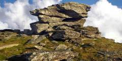
Anvil Rock perches above Nome, an early landmark for gold miners and an easy hike for those who want to take in spectacular views of Nome, the Bering Sea, and the Kigluaik Mountains. Its resemblance to a blacksmith’s anvil generated names for many nearby landscape features, including Anvil Mountain and Anvil Creek. The hike also promises a good chance to see musk oxen, birds, and maybe even reindeer or red fox. ...more
Heading north, there are two turn-offs for tundra ridge hiking with great views of the surrounding area
Take the hike up Anvil Mountain for incredible views of the city of Nome and the Bering Sea beyond. Running up and down the mountain can be done in 22 minutes, as proven by the local cross-country team. You’ll probably want to take it a little slower, to enjoy the tundra flowers, wildlife and view from the top.


