By Bob Kaufman
Founder, Alaska.org
The country you’ll see on Denali flightseeing tours may be the most spectacular on earth. That may come across at first like a tall claim—after all, our planet is a very big place—yet this flight tour highlights some of its highest granite walls, its deepest trench, its highest mountain from base to summit…and the list goes on.
This page shows highlights of Denali flightseeing tours from Talkeetna, all of which offer close-up views of the rock faces and glaciers of Denali.
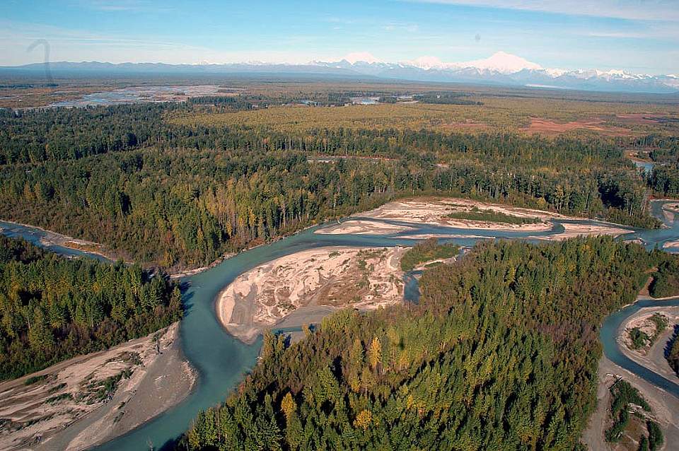
Susitna River Valley
Liftoff from the tiny village of Talkeetna and look down on the three great rivers which converge here: the Talkeetna, Chulitna, and Susitna. These mighty rivers drain the entire south side of the Alaska Range. It’s hard to believe the rushing waters are nothing more than meltoff from the glaciers you’re about to see 50 miles distant. The plane banks over the Susitna River, a mile-wide river plain with dozens of braided channels.
The vast upper Mat Su Valley reveals itself, part of the Mat Su Borough. It’s the size of West Virginia with only 65,000 residents. You cross the Parks Highway, built in 1971 to connect Anchorage to Fairbanks. You’d have to fly another 500 miles west—all the way to Siberia—before you’d cross another road. Three green river country below is rich with life. The omnipresent beaver is too small to spot, but moose may make an appearance. Migratory waterfowl fill the air, and in the rivers are five species of salmon. You’ll pass over cabins owned by real Alaska frontiersmen. They’re far off the road system: you’d need a snowmachine, airplane, or ATV if you lived back here.
Tokositna Glacier Country
Cross the Tokositna River which marks the southeast corner of Denali National Park. Look for tents or rafts next to the river. While difficult to access—even by bush plane—this area is a prime place for camping, exploring, and to begin a raft trip down the Tokositna River to Talkeetna.
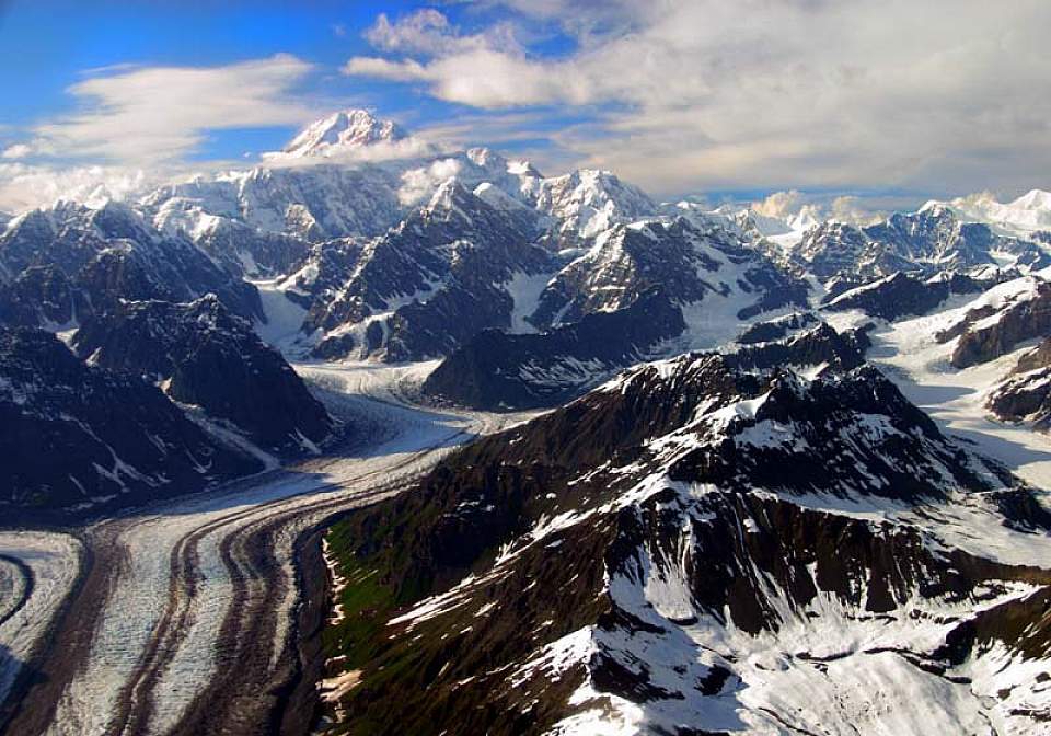
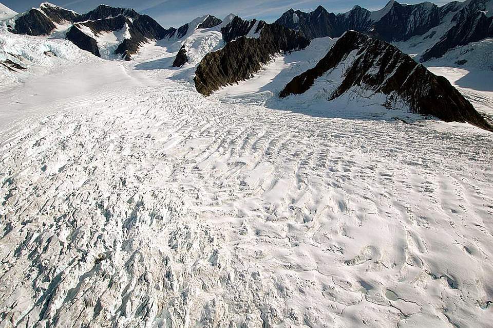
Out the left window, you can look south to the Peters & Dutch Hills, an active gold-mining area since the early 1900s. A winter wagon road from Talkeetna kept the area stocked with supplies. The Tokositna Glacier appears. This 25-mile long river of blue-tinted ice is 3 miles wide in places. Snow accumulation creates glaciers, which flow downhill, carry rock and debris to their terminus, then melt and feed the local river systems. Look for crevasses, sapphire ice, and blue pools of glacial melt water. Why blue? The ice is so dense, it reflects only blue light back.
Denali (Mt. McKinley) Base Camp
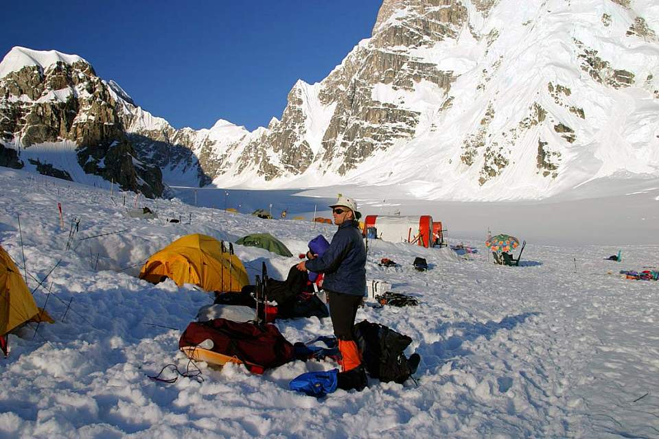
The Kahiltna Glacier is the longest in the Alaska Range—a 45-mile long river of ice! You’ll cross it 35 miles up it, at an elevation of 5500 feet above sea level.
See any dark specs on the surface of the glacier? Those are the climbers and tents of Denali basecamp! Most climbing expeditions begin here. A base camp manager coordinates communications between climbers and air taxis. During the busy climbing season, there can be over 500 climbers going up and down the mountain. Climbers affectionately dub it “Kahiltna International Airport.” As you climb the Kahiltna Glacier, look for climbing teams slowly trudging their way. Climbers travel roped to each other (in case of crevasse falls), on skis and snowshoes, and don’t use oxygen. It might be in the 60’s in Talkeetna, but outside the plane, the temperature gauge reads a balmy 10 degrees above. Compare that to 95 below zero, the coldest recorded temperature on the mountain, or minus 148, the wind chill experienced by the first winter ascent party in 1967.
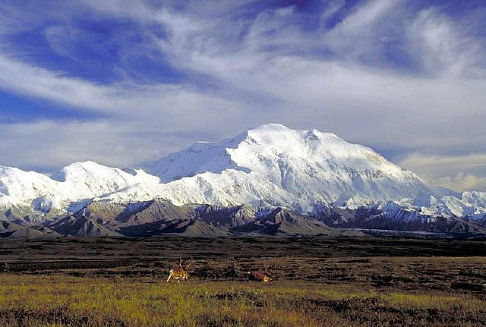
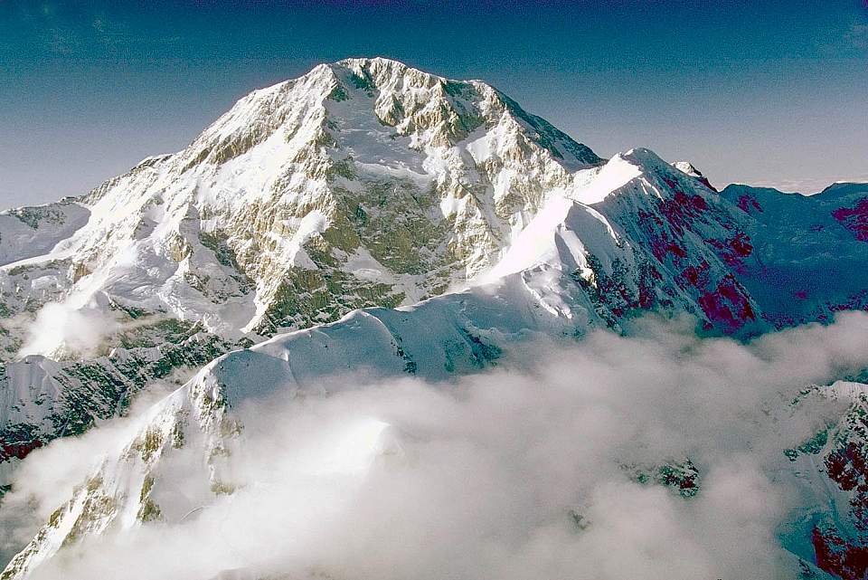
Denali (Mt. McKinley)
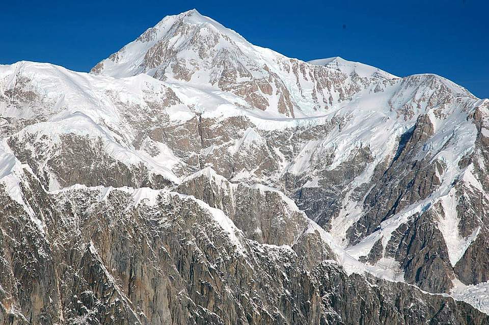
Soaring high at 20,320 feet is Denali. Named Mt. McKinley in 1896 by a gold prospector in support of then-presidential candidate William McKinley, the mountain was renamed in 2015. Inhabitants of the area have referred to the peak as "Denali" for centuries, meaning "the great one" and "big mountain".
Equally impressive are its nearby cousins: Mt. Foraker (17,400), and Mt. Hunter (14,573). From Talkeetna, these three dominate the skyline. But up here on the “Roof of North America,” you are surrounded by ridges and peaks, all higher than any mountains in the Lower 48. They form 600 miles of massive mountains called the Alaska Range. The top of this arc of peaks lies within Denali park and extends to the Pacific Coastal Range, which stretches to Central America. The scenery is mind-boggling. Cornices perch precariously atop these ridges. Hanging glaciers the size of shopping malls fall off their flanks. And fluted ridges thousands of feet high rise up nearly vertical slopes. Check out the rock. Most of it is gray granite. But some of it is sedimentary. Over the past 65 million years, an ancient ocean has subsided. Fish fossils have been found nearly four miles above sea level.
North Face of Denali
If you choose an “Around the Mountain Tour” (circumnavigates the mountain), you’ll ascend over the top of the Kahiltna Glacier and on to the north side of the Alaska Range. Look to the right, and you’ll see the 14-mile-wide Wickersham Wall. From the peak it's 17,000 feet down, one of the greatest unobstructed vertical drops in the world. Considered a death route, the Wickersham has been climbed only a few times. A Romanian ski instructor skied down the wall in the 1990's totally unsupported. His biggest scare? Encountering a bear on the hike out to Wonder Lake… Beneath the left wing is the Muldrow Glacier two vertical miles below. It’s the longest glacier on the north side and the traditional approach for climbers who start at Wonder Lake, which you can see 25 miles distant. The original ascent party used this route to summit the North peak in 1910-carrying a 14-foot spruce pole and 6x12 foot American flag! The views to the North are very different. You’ll see the 90-mile long Denali park road which you’ll travel if you take a tour into the Park. But then the rugged landscape abruptly tapers off into rolling tundra that stretches as far as the eye can see into the Interior of Alaska.
Mt. McKinley South Buttress
You’ll traverse the spine of the north side of the Alaska Range for about 15 minutes, then fly through a mountain pass known as the Tralieka Col, back to the south side of the range. You’ll pass by the foreboding East Face of Denali (its only major unclimbed face) and descend down the West Fork of the Ruth Glacier. Look for pyramid-shaped Mt. Huntington off the right window, thought by many to be the most picturesque peak in North America. Though not as high as its loftier neighbors, its 3-mile long knife-edge French Ridge is one of the technically most demanding climbs in the Alaska Range.
Ruth Ampitheatre & Glacier Landing
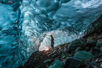
You enter the Sheldon Amphitheatre, named after a bush pilot who built a viewing hut here on the glacier before it became a national park. You can stay here for $100 a night. It has a wood stove and bunks 6. If you opt for a glacier landing, this is where you’ll likely land. You’ll step out of the plane and onto an ice sheet nearly a mile thick. The scale of the Amphitheatre is hard to fathom. You’ll feel like you can reach and out touch the “nearby” peaks…until your pilot tells you they are in some cases ten miles away. Don’t forget to take some pictures, have a snowball fight, make snow angels…do whatever you want…you don’t get many chances in life to travel back into the last Ice Age!
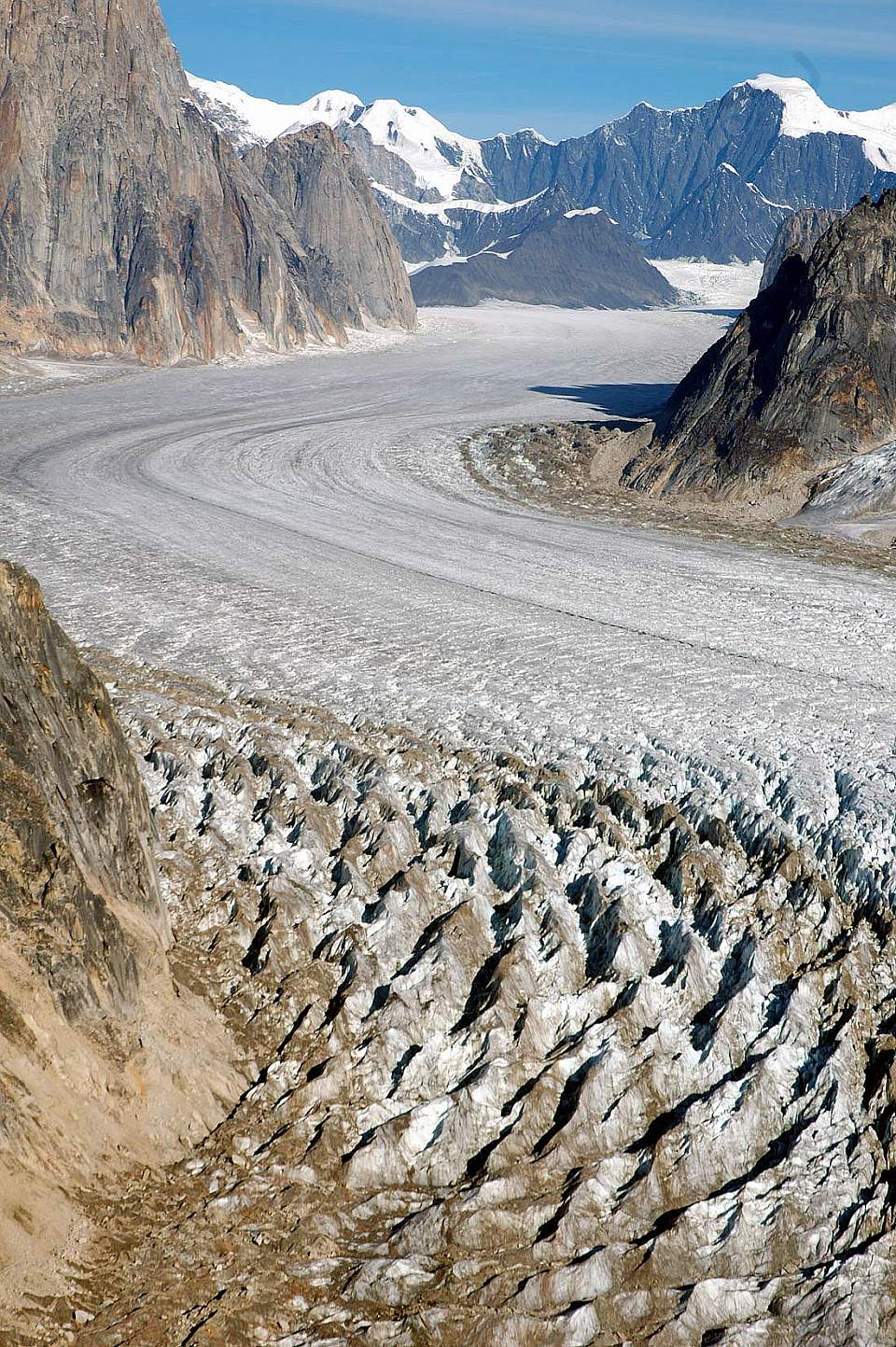
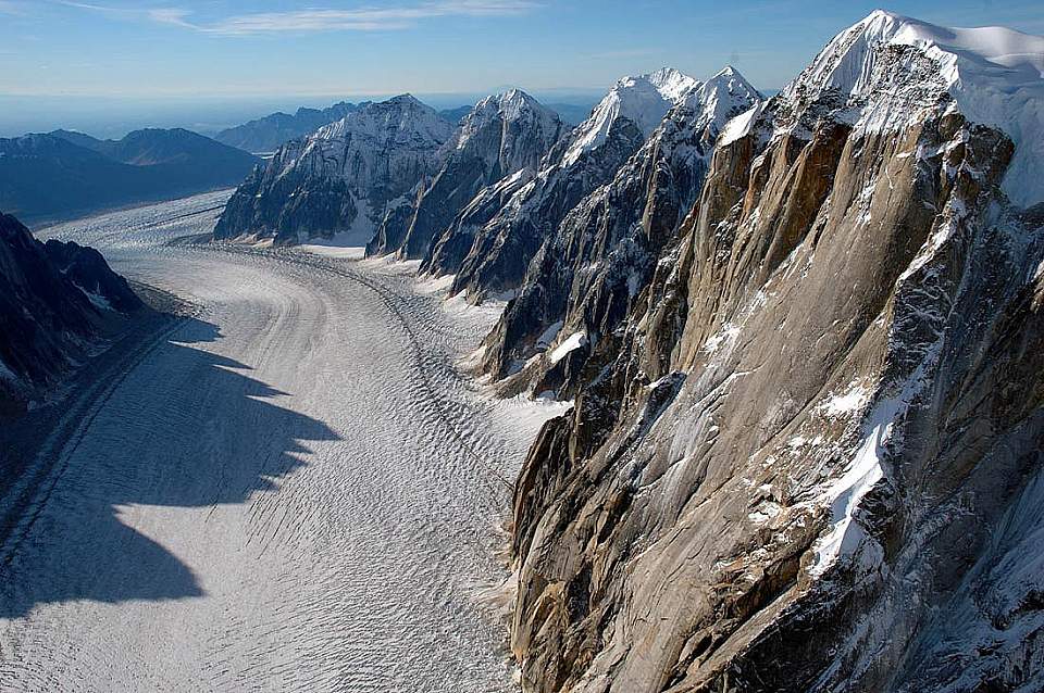
Great Gorge of Ruth Glacier
You enter the Great Gorge of the Ruth Glacier—the world’s deepest. The ice is 3700 feet deep, some of it more than a thousand years old. The surrounding walls soar 4000-5000 feet above. Were the ice to melt tomorrow, you would witness a spectacle twice as awesome as the Grand Canyon—a gorge a mile wide and nearly two miles high. Watch for climbing camps….
These may be the world’s most impressive granite monoliths. You’ll stare in disbelief at mile-high spires of sheer granite with names such as Moose's Tooth, Broken Tooth, and Bear Tooth. 100 miles to the south, these features are very identifiable and really look like animals' teeth. So immense, what appear to be tiny flakes on these walls are actually ledges wide enough to park a tractor trailer.
On the right is Mt. Dickey, the highest granite wall in North America. It would take two Yosemites, one stacked atop the other, to equal its height. After fresh snowfalls or in the early morning sun, you might see avalanches raking down it. The sun's warmth releases them into a shower of rock and ice that ricochets for a vertical mile before slamming into the glacier floor, sending reverberations a dozen miles. Experienced climbers recognize avalanche-prone slopes and stay clear... (gene looking up)
As the Ruth Glacier flows down a steeper gradient, it tears and fractures into a treacherous and virtually impassable 10-square mile section known as the Ruth Ice Fall.
Lower Ruth Glacier
Flying down the medial moraine of the Ruth Glacier is mesmerizing. This 25-50 foot high ridge of rock debris looks like an excavation pit that extends for miles down the center of the glacier. Keep on the lookout for deep blue pools of ice melt. Look for lateral moraines on the sides of the glacier and the terminal moraine at the toe of the glacier…
You’ll know the terminus of the Ruth when you see it: the contortions of earth and ice resemble a bomb blast's aftermath. Gravity rams this great jumble of earth and ice into the river country below, obliterating all in its path.
The full-grown forests you see on the terminal moraine? Those are actually spruce trees growing precariously atop diamond-hard glacier ice. When the ice melts, they will meet a violent demise—getting pitched headlong into the raging river which emerges from the glacier's snout below.
A subterranean river of glacial melt erupts through the ice at the base of the Ruth Glacier, a feature known by local pilots as "The Bubbling Pond." Hardly bubbling, it emerges with the deafening roar of a 747 engine and enough force to throw refrigerator-sized boulders 10 feet in the air.
You’ll fly low down the Ruth River, onto the Tokositna and Chulitna Rivers, and back into Talkeetna. Along the way, you’ll see blue alpine lakes shimmering against emerald green hillsides—one final reminder of a paradise of mountain scenery you will never forget.
Talkeetna from the Air
Only moments after takeoff, you'll look down on Talkeetna and appreciate its setting at the confluence of three great rivers and along the Alaska Railroad. The road to Talkeetna was built years later.