Chiniak Highway Guide
A curvy road following the shoreline south from town, this 42-mile highway will take you past the U.S. Coast Guard Station, salmon streams, long ocean inlets, and exposed surf beaches. You’ll also see the tiny outpost of Chiniak, which has a post office, elementary school, and a population of around 50. Along the way, anglers can wet their line at Russian Creek, Salonie Creek, and American River. History buffs can wander among the old batteries and airstrips from WWII. This road also connects to Pasagshak Road, which leads to the Alaska Aerospace Corporation’s Launch Complex, Pasagshak Bay, and Narrow Point. There’s a new lodge and restaurant at this fork, Olds River Inn; stop in for a bite and get the latest news from owners Fred and Mary Barber.
Show Map
Highway Guide

A popular place for viewing wintering Emperor Geese.
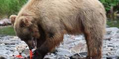
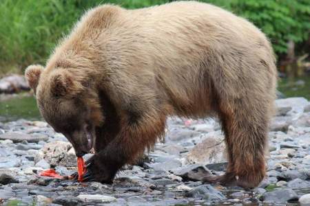
From this bridge on Kodiak’s Chiniak Highway it’s possible to see spawning salmon in August and September. There’s also potential to see brown bears here during the late summer as they feast on salmon, especially around dawn or dusk. The road on the south side of the bridge leads to Bell’s Flats.
Good fishing site. Kodiak Island Sportsmen Association Firing Range.
A six-mile round-trip hike that climbs to just over 2,000 feet, this climb will get you great views of Women’s Bay and the rolling mountains of the island. Look for ptarmigan up here…this is a hike the Audubon Society does annually.
MP 12.8, Chiniak Highway
Follow the trail that winds upward through tall grass crossing some wet places. After about 1.5 miles, you come to the lake, which is a beautiful place for a picnic or swim on a sunny day. Keep an eye out for upland birds, bear, deer, and goats.
Happy beach is a black sand and stone beach. Listen to the waves crash against the shore and smell the fresh ocean smell. Beachcombing, picnicking, & hiking are all great things to do in this area.
There’s a radio receiver & emergency phone available to the right.
MP 17.7 , Chiniak Highway
Stop off at the bridge and fish or raft on American River (there’s a good fishing spot to the left when you get to the bridge).
This is a well-used and busy ATV road that leads up the American River and over a pass to Saltery Cover. It is only open to trail bikes, ATVs and hikers. While it is possible to hike the road, be aware that you will need to ford some streams.
This is the former site of a Russian brickyard and is currently the site of an archaeological excavation. You can also access the Iron Gate Beach.
Mayflower Beach is a black sand and stone beach with views across the bay to forested hills and mountains. Listen to the waves crash against the shore and smell the fresh ocean smell. Beachcombing, picnicking, & hiking are all great things to do in this area.
MP 24.4, Chiniak Highway
During August and September, the ditch on the left of the Chiniak Highway at MP 29.0 becomes an active spawning area for salmon.
Sheer cuts along river bank reveal a heavy volcanic ash layer from the eruption of 1912.
A 17 mile one-way jaunt from Chiniak Highway, this road was completed alongside the development of the Alaska Aerospace Corporation launch site, which is at the end of the road. In addition to accessing the private site, the paved road offers recreationalists and travelers access to great fishing beaches and rivers, surf spots, state parks, and scenic views of alpine passes and ocean. There’s also a private ranch here, where semi-domesticated… ...more
This is a great place to spot fishing boats as they come in and out of the dock.
An assortment of homes and cabins dots the road for the next two miles and comprises the town of Chiniak. Originally a native Alutiiq outpost, the population here exploded during WWII, following construction of a road from Olds River. The Army, Navy, and Air Force have based operations here, with workers living in Quonset huts and military housing. But following the closure of the housing in 1954, the residents built the “town.” Electrified in… ...more
MP 41.6, Chiniak Highway
This is a very scenic and easy hike with great birding and flower viewing. During April and early May this is a prime location to view migrating gray whales. Check out all of the rocky outcrops, beaches and offshore waters for birds. Look for bank swallows nesting in the sea cliffs and harbor seals lounging on the rocks.
This old bunker is open for exploration. If you make it this far on your hike, be sure to walk around the bunker and step inside to get a rough idea of how how soldiers lived during WWII.