Iditarod National Historic Trail

Distance

6 miles

Difficulty

Easy

The Iditarod National Historic Trail is Alaska’s sole National Historic Trail. This network of 2,300-mile winter trails evolved to connect Alaskan Native villages, established the dog-team mail and supply route during Alaska’s Gold Rush, and now serves as a vital recreation and travel link.

Much of the trail is not passable without snow cover, at least without webbed feet and serious mosquito repellent. However, there are several sections in the Kenai Peninsula and along the coast in Nome that are accessible for year-round hiking:

  • From Seward’s Iditarod Monument, you can walk north along a paved bike path along Resurrection Bay
  • Just north of Seward (mile 2.1 of the Seward Highway) at Nash Road, you can access a mostly-flat section of the trail to Bear Lake, 4 miles away. In the winter, Bear Lake is groomed for cross-country skiing and snowmachining
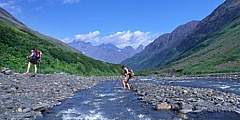
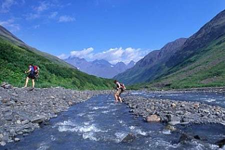
  • A popular mountain-bike route, the Johnson Pass Trail, affords alpine and waterfall views as well as a workout over a 24-mile one-way trek
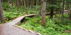
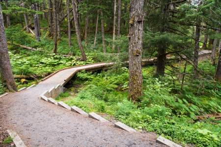
  • From Alyeska in Girdwood, the Winner Creek Trail offers well-maintained access to the trail for the first few miles, with the option to extend into remote valleys via the Upper Winner Creek and Twentymile Trails
  • Up Crow Creek Road in Girdwood, much of the popular, challenging Crow Pass Trail follows the historic Iditarod Trail.

During mail route days, mushers relied on roadhouses throughout the Iditarod Trail system. Today, several public shelter cabins are maintained along the trail.

Getting There

Coordinates
Latitude: 60.944592
Longitude: -149.169382
Driving Directions

Show Map

Iditarod National Historic Trail Points

Walk, run, or ski the Idi­tar­od Trail from Nash Road, end­ing at Bear Lake. It’s most­ly flat, though not all parts of the trail are groomed in the win­ter, and might be more suit­ed for clas­si­cal ski­ing. The trail goes onto Bear Lake in the win­ter, which is groomed for clas­si­cal ski­ing, skate ski­ing, and snowmachining.

The coastal walk fol­lows the route of the orig­i­nal Idi­tar­od Nation­al His­toric Trail, used heav­i­ly from 1909 to the mid-1920’s to sup­port min­ing com­mu­ni­ties on Tur­na­gain Arm with mail and sup­plies arriv­ing at Seward’s ice-free har­bor by steamship.

Difficulty: Easy Distance: 23 miles

The John­son Pass Trail orig­i­nat­ed in the 1890s as a route for Idi­tar­od min­ers who raced north from Seward to Nome. It lat­er was devel­oped into a wag­on road by mer­chants and min­ers who set­tled the area. The Alas­ka Road Com­mis­sion then used it as a thor­ough­fare through the 1930s. Today this pop­u­lar hik­ing trail trav­els por­tions of the his­toric Idi­tar­od Trail between Moose Pass and Gran­ite Creek with bridged streams, most­ly easy grades, and…  ...more

Difficulty: Easy

Win­ner Creek Trail in Gird­wood (45 min­utes south of Anchor­age) is one of our favorite trails to take vis­it­ing friends and fam­i­ly. It’s an easy 3‑mile hike or bike ride on a wide, well-devel­oped trail with a gen­tle ele­va­tion gain that winds through America’s north­ern­most rain­for­est, cross­es a wood­en bridge over a thun­der­ing blue-water gorge. 2022: Hand tram cur­rent­ly closed, may replace with bridge. Local weigh­ing in.)

Difficulty: Moderate Distance: 21 miles Elevation Gain: 3500 feet

Con­sid­ered to be one of the best hikes in all of the Chugach Moun­tains, Crow Pass fol­lows a por­tion of the orig­i­nal Idi­tar­od Trail, includ­ing its high­est point. End to end, it’s a 21-mile trail, which most peo­ple do in 2 days, but just the first 4 miles will lead you past some breath­tak­ing scenery. Along the way you’ll find glac­i­ers, water­falls, wild­flow­ers, wildlife, mine ruins, and berries (in late August and Sep­tem­ber). Hik­ing is not  ...more