Well-maintained and suitable for summer hiking and biking, the 10-mile Devil’s Pass Trail features a steep route up a spectacular V-shaped valley that intersects with the Resurrection Pass Trail and a rental cabin in the alpine realm. The country is rugged, with great access to cross-country tundra exploration and berry picking.
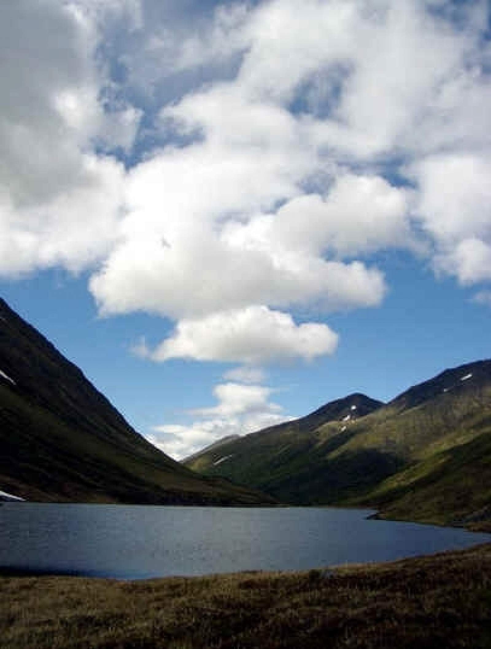
Near the top, you’ll find an unexpected gem: Devil’s Pass Lake with potential fishing for Dolly Varden.
Many people use the trail as an alternative entrance or exit to the Resurrection Pass Trail system, or as a quicker approach to the Devil’s Pass Cabin on the trail. Distance to Resurrection south trailhead near Cooper Landing is 27 miles. Distance to the Resurrection north trailhead near Hope is 32 miles.
Devil’s Pass-Summit Creek loop
The trail also anchors a 20-mile backpacking loop to-and-from the Seward Highway through some of the most spectacular above-treeline country in the Kenai Mountains, via the less-visited Summit Creek Trail. Although the Summit portion is not suitable for biking and not recommended for winter travel, the loop makes for a great weekend overnight trip for people on foot.
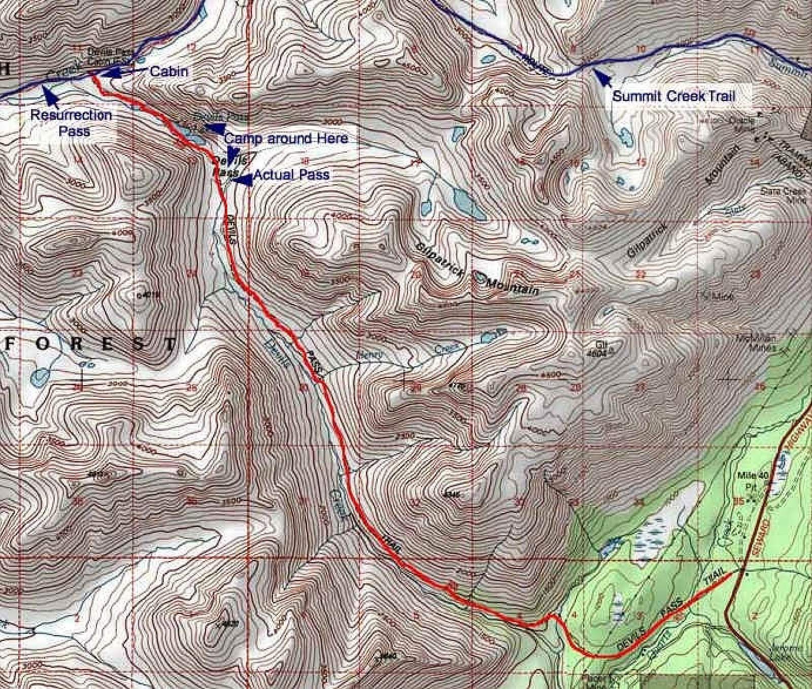
From the trailhead, climb to Devil’s Pass and then go north on the Resurrection Trail a few miles north to the Pass itself, where you pick up the single track Summit Creek Trail. The 9-mile descent to the highway traverses several tundra valleys and ridges, offering sweeping views and a good chance to see caribou. The exit trailhead is at Mile 44, across from the south end of Summit Lake, only 4.5 miles north of the Devil’s Creek trailhead.
Tip: First timers doing the loop might consider starting at Summit Creek Trailhead at Mile 44. This avoids any difficulty finding Summit Creek Trail’s intersection with Resurrection Pass Trail. (Devil’s Creek Trail intersection is obvious.)
Devil’s Creek Trail details:
- From the trailhead at Mile 39.5 of the Seward Highway, the route cuts through forest for about three miles and features gentle grades. The Beaver Pond campsite at Mile 2.3—just outside the entrance to valley and the start of steep climbing—has fire ring and a bear-resistant locker.
- The trail climbs steeply into the valley, often skirting along slopes a few hundred feet above the creek. A campsite at Mile 5.3 features a bear resistant locker.
- Devil’s Pass at about Mile 9 offers sweeping alpine views. A side hike into the open country rising to the east leads to tarns nestled in hanging valleys beneath the rugged Gilpatrick Mountain.
- Devil’s Pass Lake fills the valley floor just beyond. Look for rising Dolly Varden in the evening light.
- Devil’s Pass Cabin and Resurrection Pass Trail lie one mile past the lake. Several campsites are nearby on the Resurrection Pass Trail.
- Wildlife includes moose, caribou, black and brown bears, wolverines, ptarmigan, grouse and marmot.
Trail features with GPS :
- Mile 2.3 Campsite N 60° 33’ 14.7” W 149° 37’ 37.5”
- Mile 5.3 Campsite N 60° 34’ 19.1” W 149° 40’ 47.8”
- Devils Pass Cabin N 60° 37’ 17.5” W 149° 45’ 7.9”
- Campsite on Resurrection Trail (one mile west of Devil’s Pass Cabin) N 60° 36’ 53.3” W 149° 46’ 34.9”
Some things to keep in mind:
- Avalanche hazards. The route crosses many avalanche paths and is not recommended for winter travel. If attempted during snow season, be prepared to recognize and avoid avalanche danger.
- It’s bear country. The Kenai Mountains feature prime brown bear habitat, and the forests abound with black bears. So take all the usual precautions—including storing food in bear lockers or portable vaults, keeping a clean camp and carrying bear spray for deterrence.
For more information:
Current conditions
Contact the Seward Ranger District, 33599 Ranger Station Spur (mile marker 23.5), Seward, AK 99664. (907) 288-3178
Real-time road weather at Mile 45.8 by Summit Lake
For online trail profiles:
Resurrection Pass Trail north access
Resurrection Pass Trail south access
For fact sheets, maps and GPS coordinates:
Devil’s Creek Trail fact sheet and map (PDF)