20 Things You'll See On A Kenai Fjords Boat Tour
Shimmering water, majestic peaks, and an impressive array of wildlife: a boat tour of Kenai Fjords National Park is the best way to take it all in. In this guide, rangers from Kenai Fjords National Park give you the scoop on what to look for—things that you otherwise might not know about. Learn about the oceanside town of Seward, impressive peaks and glacially carved valleys, and things to look for in the water and on the seaside cliffs. And of course, you’ll learn about the wildlife: the whales, bald eagles, stellar sea lions, harbor seals, puffins, mountain goats, and sea otters who call this area home.
Show Map
Walking Tour Points

If you had looked at the Seward waterfront area before 1964, you would have seen fish processing plants, warehouses, a small boat harbor, various pleasure and commercial vessels, and huge Texico and Standard Oil tanks. You would also have seen the Alaska Railroad facilities and tracks which ran to the south end of town near where the Alaska Sea Life Center is today. That’s where steamers would come in to off and on load materials. The bulk of… ...more
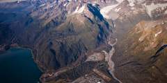
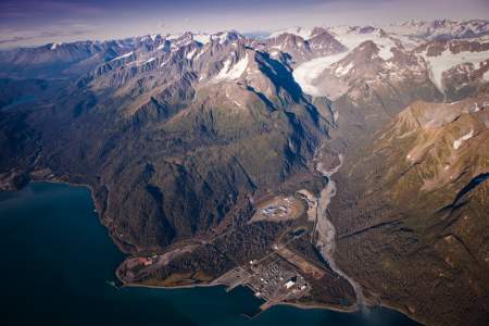
One hundred and fifty years ago the valley now occupied by the ship facility and correctional center was filled with the ice of Godwin Glacier. If you look just below the 4 mountain peaks to the left side of the valley you can see the ice of Godwin glacier. In the year 1850 this glacier calved icebergs into Resurrection Bay waters. Now a days Godwin glacier is a valley glacier and behind the low hills you see in the foreground Godwin glacier… ...more
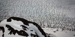
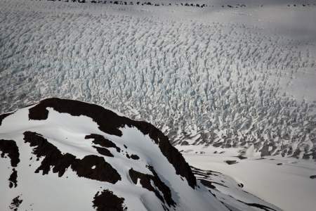
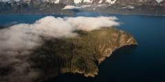
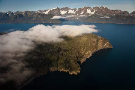
Looking beyond the peninsula you can see snowcapped mountains. Here you have a glimpse into the edge of the Harding Icefield. This icefield is the main feature of the Kenai Fjords National Park. Formed during the ice age some 20,000 years ago, the Harding Icefield is 30 miles wide by 50 miles long and in places presumed to be 3000 – 5000 feet thick. There are at least 38 rivers of ice or glaciers that flow out of the Harding Icefield. From here… ...more
Look for three alpine glaciers back in Thumb Cove. Alpine glaciers keep their ice in the alpine region of a mountain and don’t descend to a valley floor or the tidewater’s edge. From the left the three are Prospect, Spoon and Porcupine glaciers. Notice the lovely cabin on the edge of Thumb Cove. The land of the Resurrection Peninsula is divided between state park, national forest and private in-holdings. You will see several private cabins.… ...more
Around Thumb Cove, across the bay, there is a prominent headland rising 650′ above the bay. This is known as the Caine’s Head . During World War II it was the site of Fort McGilvray. By land Fort McGilvray is 6 miles south of Seward but no road connected the two. All supplies came to the fort by boat. There was a great fear that Seward might be attacked during the war. The fear stemmed from the fact that with the rail terminus being located… ...more
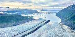
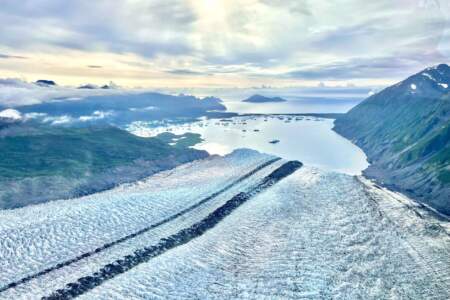
Just outside of Seward, Bear Glacier flows down from the Harding Icefield — the largest icefield entirely contained within the United States — into a long, narrow lagoon. It’s the largest glacier in Kenai Fjords National Park, stretching 12 miles from its origin. Experience by air, kayak, paddleboard, or by option for an overnight excursion near the ice.
On the ocean side (not bay side) of Rugged Island you can look up on the ridge of this island and see a bright orange and white day marker just above an old WWII military look out station. Fort Bulkley was located on Rugged Island and this ridge was the first defense if any enemy boats were to enter the bay.
As the boat pulls away from the nesting areas of the horned puffins it will turn left and again stay right next to the cliff face. You’ll notice some pelagic and possibly red-faced cormorants nesting high on the cliff just after the boat turns to the left for the final stretch of Cape Resurrection.
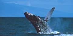
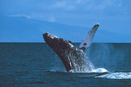
Once we leave Barwell Island the boat is as far out into the ocean as it gets. This is a good place to look for whales. Humpback and Orca whales (killer whales) are the most likely to be spotted. Humpbacks are found by the ten foot tall cloud of mist that is formed when they exhale clearing their blowhole. The obvious feature of the orca whale is its black dorsal fin penetrating the surface. Male orca whales have a six foot high fin. Whale… ...more
Another marine mammal you may encounter during this part of the trip is the Dall’s porpoise. This animal is spotted when a repeating splash pattern is seen on the surface of the water. The splash is called a “rooster tail” and is created by the dorsal fin of the animal cutting through the water at high speeds. The Dall porpoise can swim at least 35 mph and easily pass this boat. However, often times the porpoise will travel with the boat for a… ...more
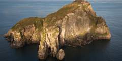
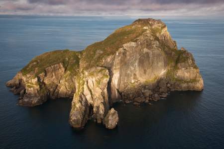
In the water, there is a triangularly shaped large rock with a smaller triangular rock in the water to its right. Atop this smaller rock we hope to find a group of the Steller sea lions. If we do not spot them here, they will be a little further south on the beach. Look for various sizes and colors of animals. Dark grey animals have just left the water, brown or tan animals have been out a while and are dryer. Fully grown males have a very… ...more
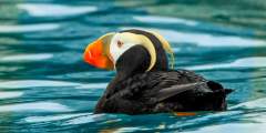
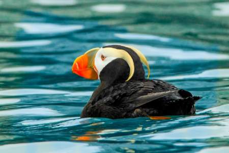
Here is the local favorite area of our Horned and Tufted puffins. You can tell the two species apart if you remember that “Tough Guys Wear Black.” The tufted puffin’s body is entirely black with distinctive long yellow “tufts” of feathers on either side of their head. Horned puffins have a white belly and black back. These puffins come to land only to lay their eggs and raise their young. Puffins spend most of their lives about 400 miles away… ...more
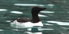
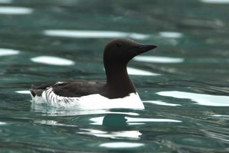
Some of the little caves on the tip of the cape contain nesting Common murres. You may also be seeing many of these murres on the water. They have black heads, black backs and white bellies. They are Alcids, like the puffins, so they are diving birds that use their wings for propulsion under water. Of all the alcids, common murres can dive the deepest, plunging to record depths of at least 600 feet.In addition to the cave nesters on the Cape,… ...more
There are islands trailing off in the distance as you go out to sea. This group of islands is called the Chiswells and was formed in the same manner of the two islands ahead of you towards the one and two o’clock positions. (Rugged and Hive islands). Think back to the sedimentary formation, it was scraped off of a subducting North Pacific Oceanic Tectonic plate. About a mile inland of the area of subduction the North Pacific plate begins to… ...more
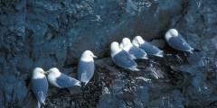
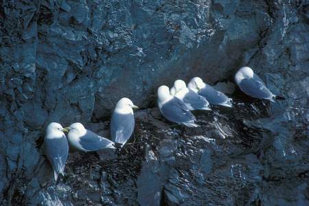
Up ahead the noise and odor of the Black legged Kittiwakes will soon become apparent. These birds take advantage of the slight depressions in the rocks to build their nests. Their nest is simply some grass and mud glued to the rock wall with their own guano. These birds nest in dense aggregations as a means of protection against birds of prey.If a Bald eagle or Peregrine falcon flies into the area every bird will leave the rocks in one… ...more
Just up ahead on the right is a small rock that sticks above the water and almost always has a mixed group of cormorants standing atop it drying out their feathers. This long necked black bird dives in the water and uses its feet to swim but unlike the puffins and other alcids has no oil in its feathers to aid in drying off. So they stand out on rocks to get dry.Just up ahead on the left you will see a rock with many gulls on top of it and… ...more