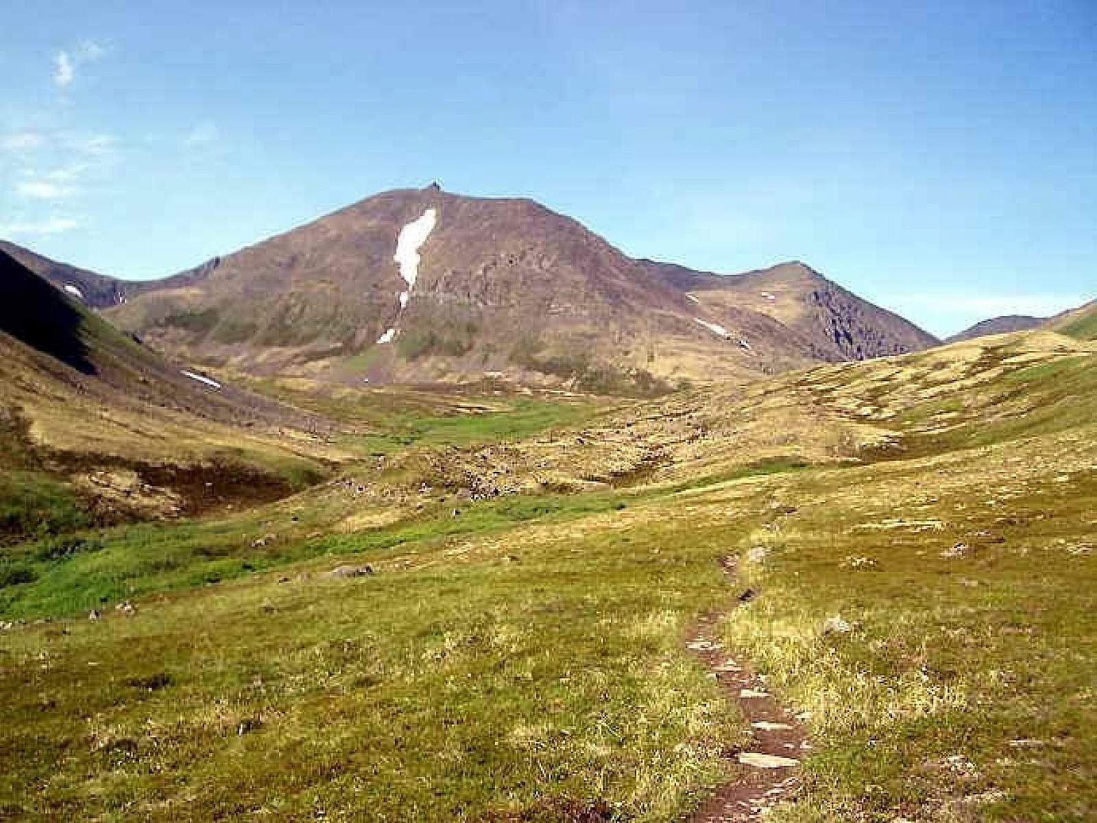
This meandering, single-track path leads to some of the Kenai Mountain’s most remote and fragile high country. On a route once trekked by gold rush prospectors, this trail ascends from spruce forest through the jungled zone of alders into a realm of sweeping tundra, with incredible views and productive berry picking. Plus, the top of the nine-mile journey ends in Resurrection Pass, about midway through the 39-mile Resurrection Pass Trail.
It’s probably the quickest hiking route from the Seward Highway into spectacular above-treeline habitat. Once above the brush (the grass that can grow six feet tall by late summer), the trail delivers true alpine serenity. You feel far away from town, like a pioneer explorer. Watch browsing caribou in the gullies.
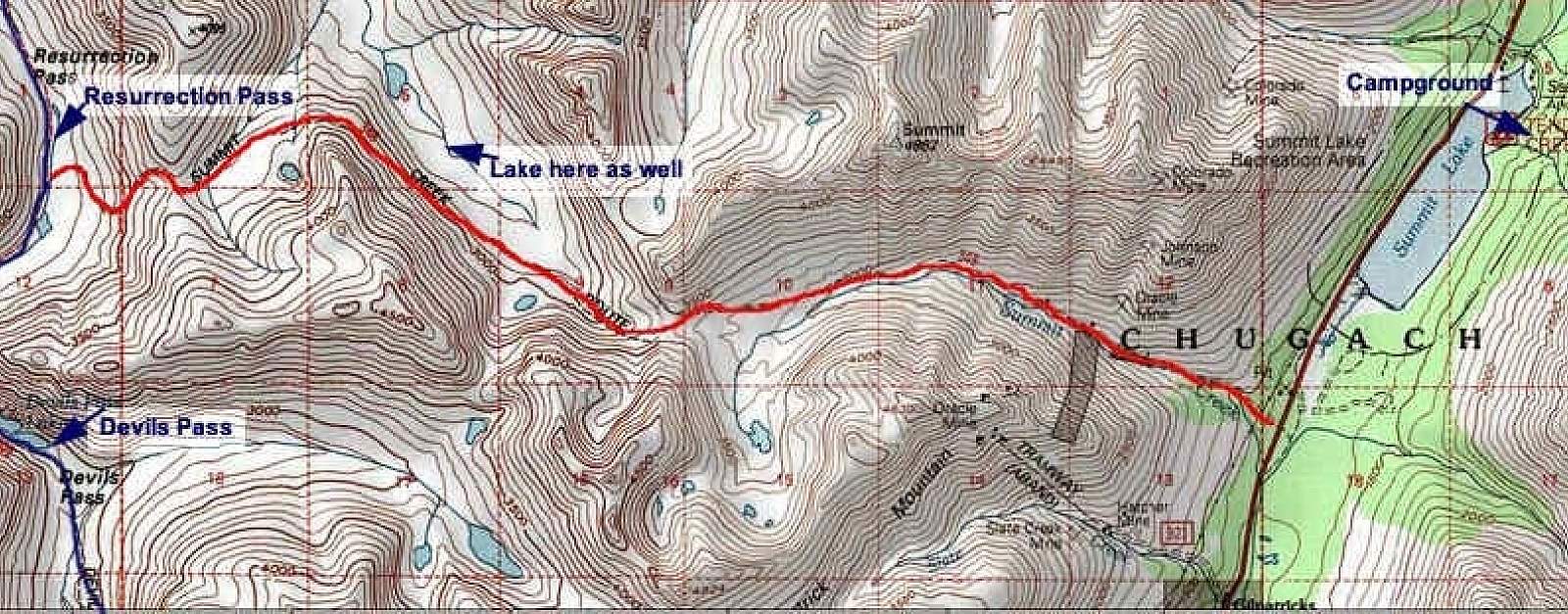
Summit Creek-Devil’s Pass loop
The trail also forms the less-known half of an intriguing 20-mile backpacking loop via the popular Resurrection Pass Trail. Not suitable for biking and not recommended for winter travel, the loop makes for a great weekend overnight trip for people on foot.
From the trailhead, climb nine miles to Resurrection Pass and then go south on the Resurrection Pass Trail a few miles to the Devil’s Pass Cabin. The entrance to Devil’s Pass opens to the south, with a 10-mile descent to the highway trailhead at Mile 39.5. Distance between the two trailheads is only 4.5 miles.
Tip: First timers doing the loop might consider starting at Summit Creek Trailhead at Mile 44 and exiting at Devil’s Creek Trailhead. This avoids any difficulty finding Summit Creek Trail’s intersection with Resurrection Pass Trail. (Devil’s Creek Trail intersection is obvious.)
Summit Creek Trail details:
- The trailhead at Mile 44 of the Seward Highway is across from the southern end of Summit Lake in a small parking area.
- The Forest Service strongly discourages biking the route, due to the fragile tundra setting and rugged conditions found on the trail. (Bikers who have attempted the trip usually report they bailed or had to walk bikes. “Not really doable,” is a frequent comment.)
- The trail veers west to cross the power line corridor, then starts climbing steeply before leveling out on a route few hundred feet above the creek gorge. By mid-summer, some portions of this lower section can be completely overgrown with tall grass, making it difficult to see your feet while walking. (If hiking after a rain, expect to get drenched from wet vegetation.)
- About 1.5 miles in, the ruins of the Oracle Mine can be found along the trail. Look for the zigzag of an overgrown mining road climbing the face of the mountain to the west.
- The trail traverses a pass at about Mile 3.5. A tarn perches in the valley to the south of the entrance. This valley also offers a rugged, backcountry route to the top of Gilpatrick Mountain, site of mining operations daring to the early 20th century. For those comfortable with route finding, and capable of steep grades, it’s possible to find a route over Gilpatrick to overgrown mining roads for an exit to the Seward Highway.
- The last few miles meanders over two ridges and a remote valley before descending to Resurrection Pass and the Resurrection Pass Trail.
Route-finding tip:
- An old, gated road a few hundred yards south of the modern Summit Creek trailhead—just down from where the trail crosses the power line corridor—leads to old mining sites and some mysterious lode mine portals. This road along the creek appears on many maps as the main route to Resurrection Pass, but it is no longer maintained and becomes overgrown and quite challenging only a few miles in. If the high country or the pass is your destination, stick to the modern trailhead! Not unless you want to spend time crawling on your hands and knees through alder thickets or bushwhacking across steep slopes.
Some things to keep in mind:
- No designated campsites on Summit Creek Trail. The country is fragile. Follow no-trace camping practices if spending the night.
- Avalanche hazards. The route crosses many avalanche paths and is not recommended for winter travel. If attempted during snow season, be prepared to recognize and avoid avalanche danger. The approach to the tundra may be difficult until snow melts in the spring.
- It’s bear country. The Kenai Mountains feature prime brown bear habitat, and the forests abound with black bears. So take all the usual precautions—including storing food in bear lockers or portable vaults, keeping a clean camp and carrying bear spray for deterrence.
For more information:
Current conditions
Contact the Seward Ranger District, 33599 Ranger Station Spur (mile marker 23.5), Seward, AK 99664. (907) 288-3178
Real-time road weather at Mile 45.8 by Summit Lake
For online trail profiles:
Resurrection Pass Trail north access
Resurrection Pass Trail south access
For fact sheets, maps and GPS coordinates:
Devil’s Creek Trail fact sheet and map (PDF)