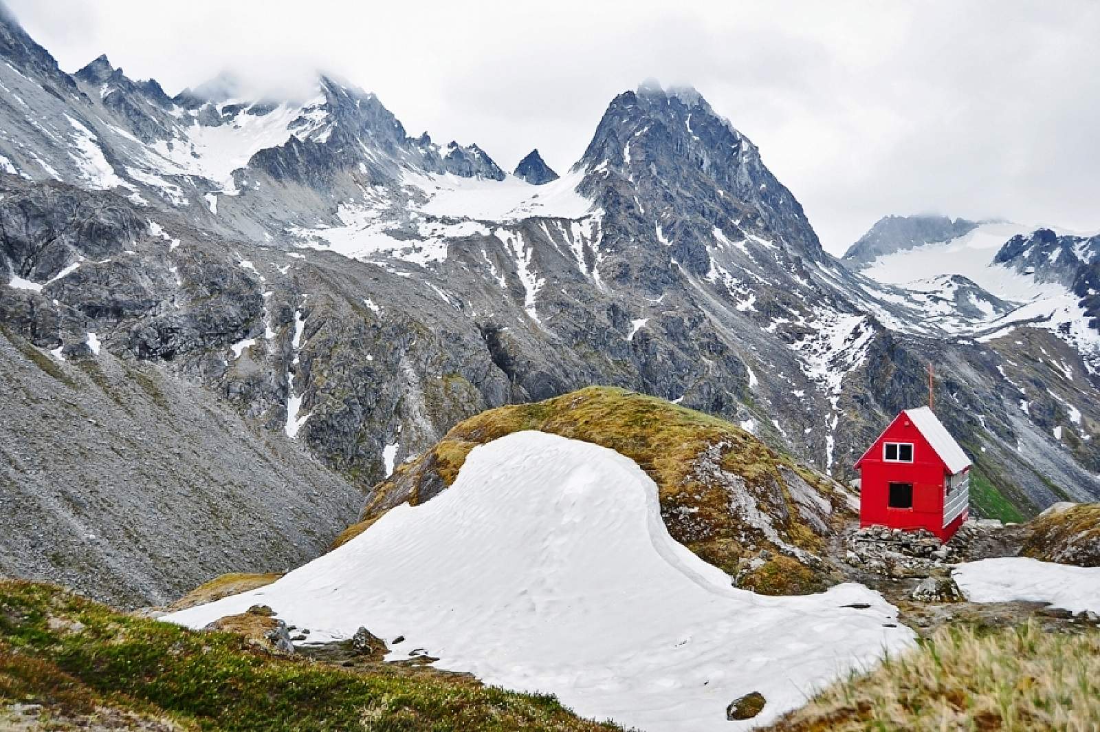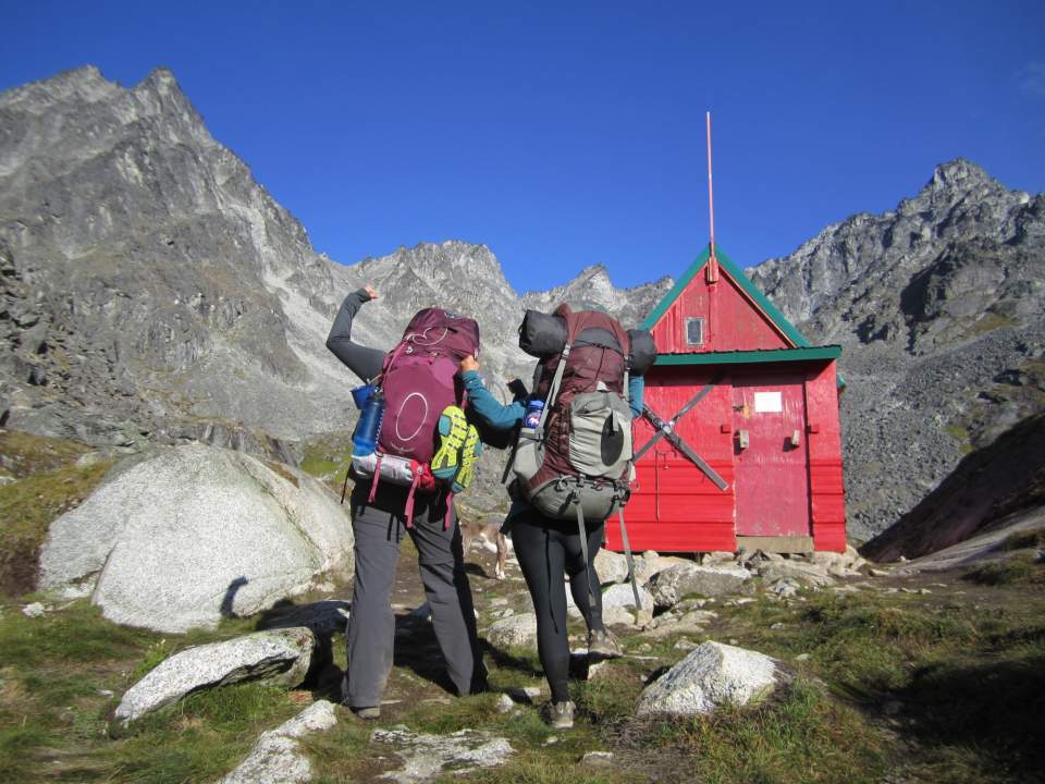
Hikers celebrate reaching Mint Hut
(Photo by Jessica Clark)
Why Take This Hike?
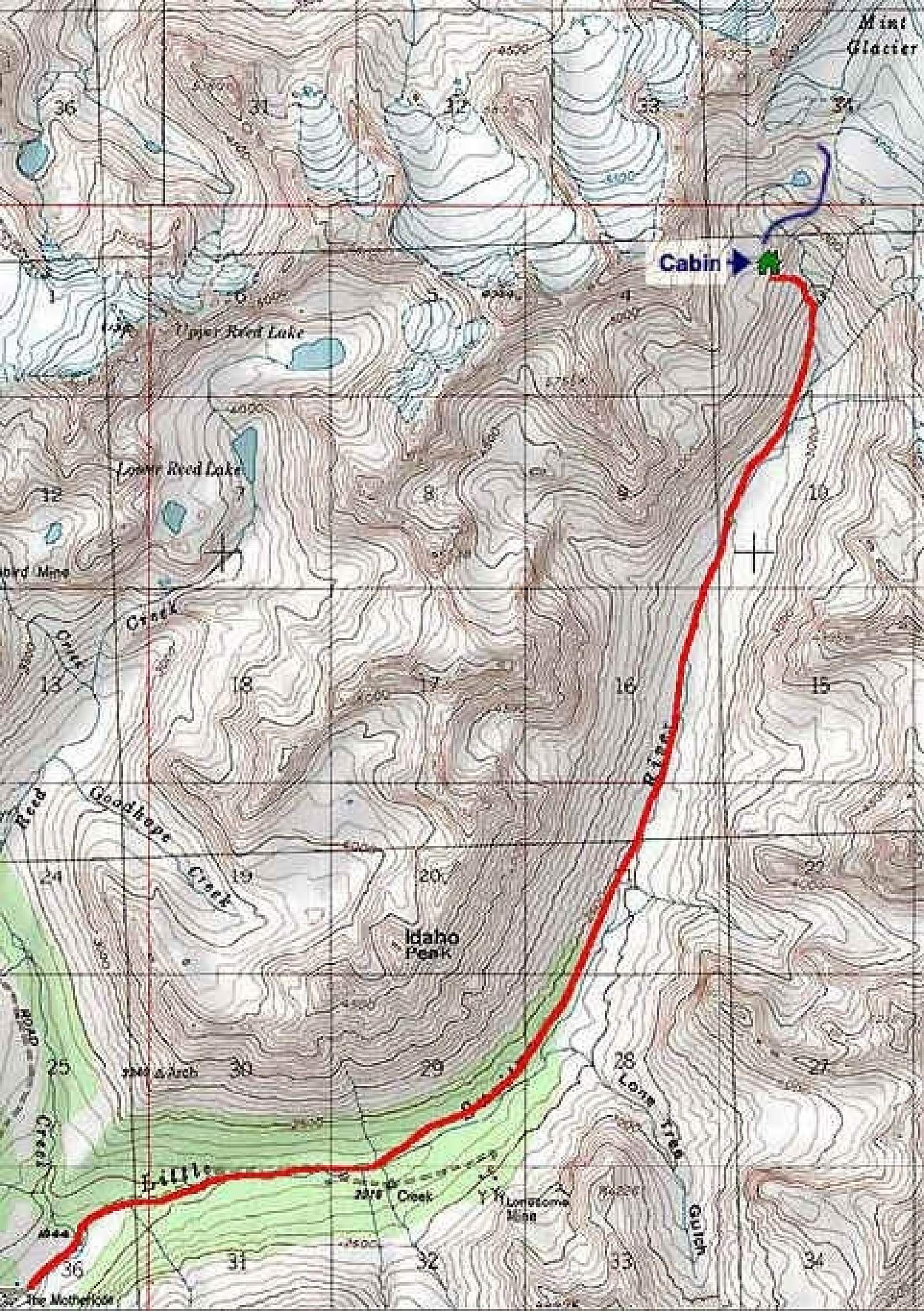
This 8-mile trail (16 round-trip), which begins 90 minutes north of Anchorage on Fishhook-Willow Road, climbs some 2,900 feet as it follows Little Susitna River back up to its headwaters at Mint Glacier. It passes beneath walls of granite-spired peaks and ridges on its way up to Mint Hut, a first-come, first-serve cabin where you can spend the night.
Day Hike
If you’re not looking for an overnight adventure, this route makes for an excellent, full day hike. About a 16 miles round trip, you’ll hike up to the Mint Hut and follow the same route back.
Backpacking
This route is a great choice for a first time backpacker. It’s a straightforward trip with big scenery payoffs, like the picturesque Mint Hut and a valley dotted with hanging glaciers. With options for additional miles and side trips, you can decide to spend one or several nights in this area.
Region
Southcentral Alaska
The Details
Follow Fishhook-Willow Road towards Hatcher Pass past the former Motherlode Lodge and you’ll come to a sharp hairpin turn up and to the left away from Little Susitna River. Here on the right you’ll find the entrance to Gold Mint Trail’s parking area. Even from here you’ll find quite a view. It stretches far up the valley, though not far enough to see its uppermost end. To marvel at that view, you have to do some hiking.
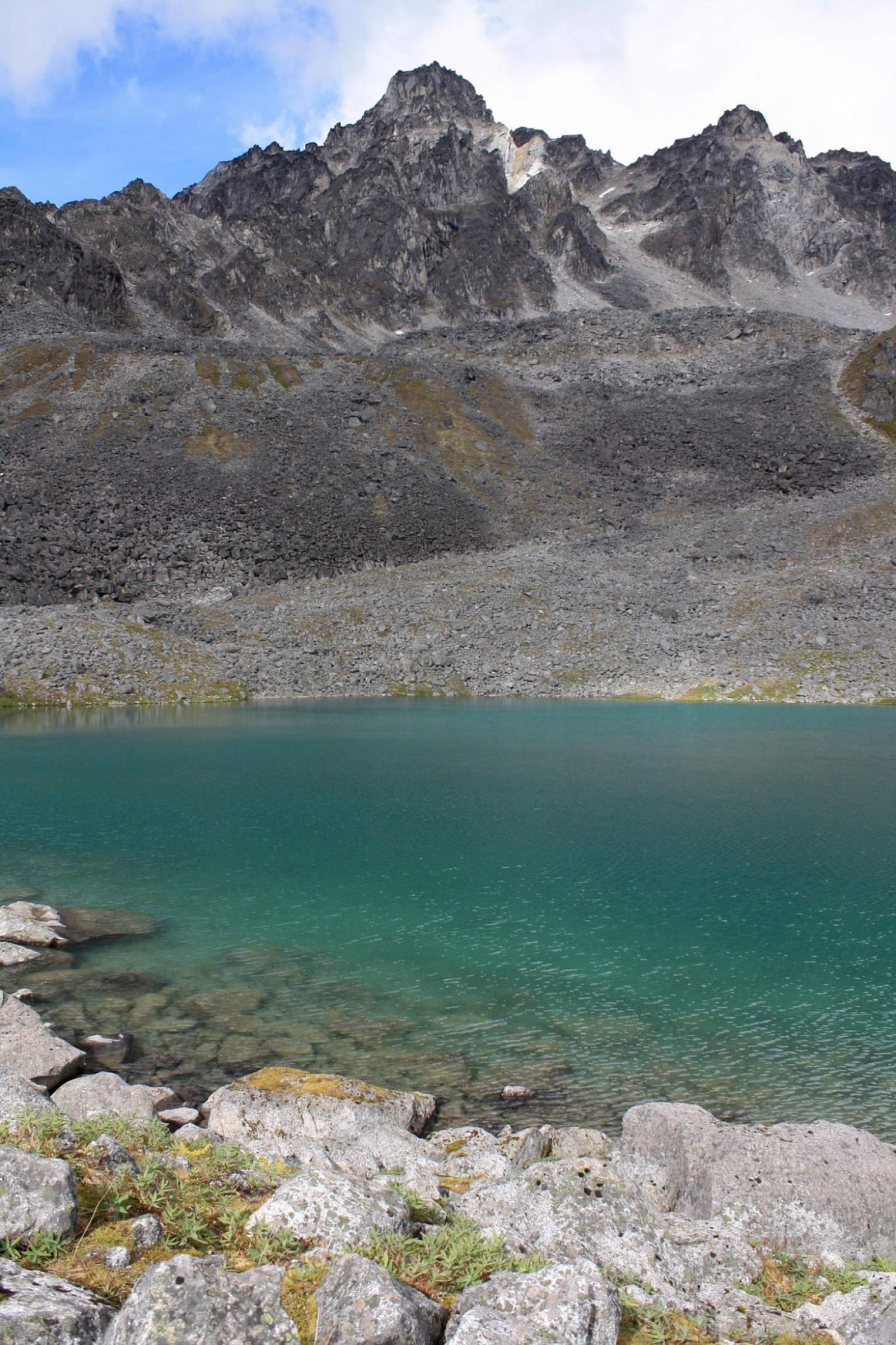
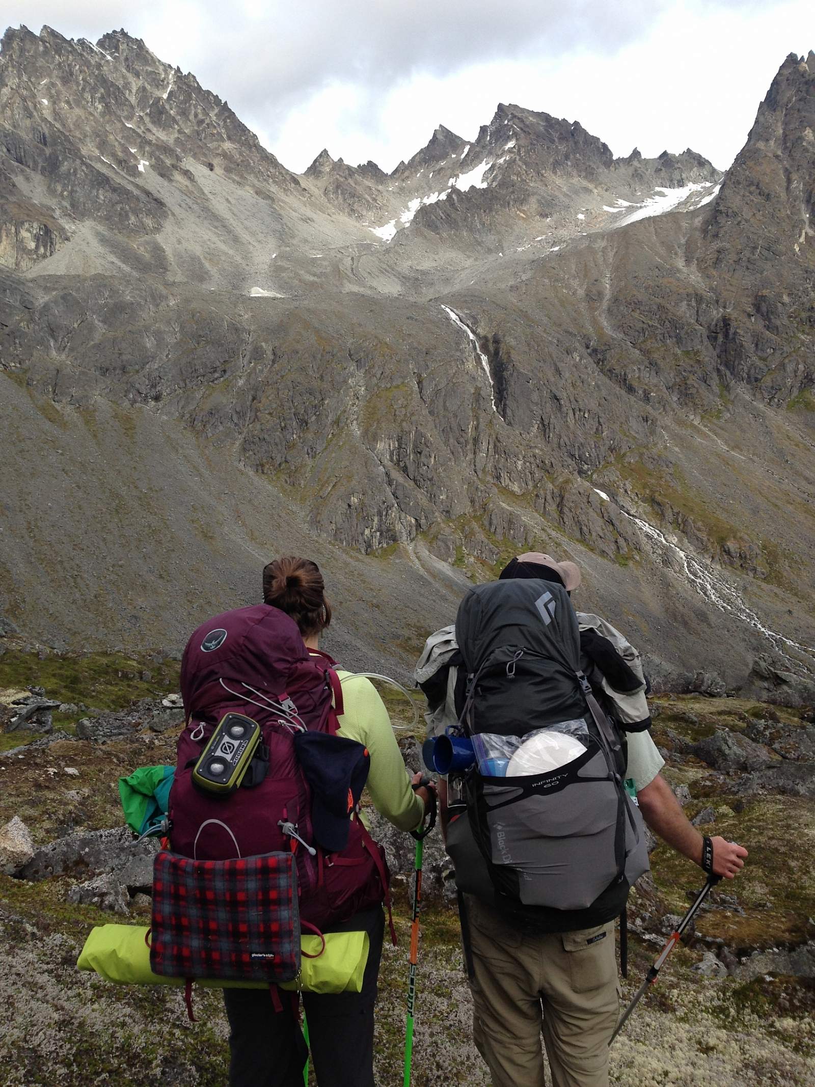
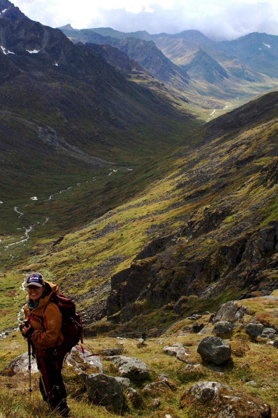
You’ll start by climbing slowly and steadily for 2 miles up an old mining road, which then narrows to an actual trail. The gradual climb continues for another 1.5 miles, during which the trail slowly turns rougher underfoot. About 3.5 miles from the parking area, and just after the trail makes a wide turn to the left, look up the river’s remaining length to the high mountains and glaciers that circle the upper valley.
(Photo by Jessica Clark)
Granite pinnacles rise on all sides as you slowly continue. The trail starts climbing with more determination near the upper end of the valley. Here, it also turns away from Little Susitna River to follow a series of cairns toward the knoll above the left side of the valley. Then the trail reaches a fork. One path leads you across the front of the knoll, while the other takes you around the back. Both soon deliver you to the door of the public-use Mint Hut, where the trail ends.
You need not stop here, though. If you still feel energetic, follow the trail beyond the cabin across the tundra and piles of moraine to the edge of Mint Glacier. Very energetic hikers might even opt to scramble the 1,200 feet up to Backdoor Gap, the small notch in the ridge behind the cabin. From the top of that narrow pass you can look down the length of Penny Royal Glacier.
But after 8 miles of hiking, maybe you just want to sit and rest. Look out upon the high peaks surrounding the cabin and listen to the water spilling down into the valley below.
You can even spend the night at the cabin if you can find room. Mint Hut is maintained and operated by the Mountaineering Club of Alaska (MCA) and you need to pay for a MCA membership before using it. It’s first-come, first-served, and it can be crowded or full. Bring a tent as backup. There many spots nearby that make for very comfortable tent sites. Then you can fall asleep amid a great circle of mountains after watching the last golden sunlight pass from their summits.
The climb from the valley bottom to the Mint Hut is steep, and the hut can be hard to find, especially during periods of poor weather. People have wandered around for hours in whiteouts, only to pitch their tent 100 yards away from the hut. A GPS is very handy if this is your first time visiting the Mint Hut and/or if you're expecting cloudy weather.
Whether staying at the Mint Hut or pitching a tent, the upper Mint Valley is amazing. Spend a day or more exploring the smaller side valleys above the Little Susitna River. Check out the Mint Glacier in Little Susitna River Valley as well as the several glaciers that are accessible over Backdoor Gap, just beyond the Mint Hut (but only do so if you're comfortable and competent with glacier travel).
Distance
16 miles, with options for additional miles and side trips.
Number of Days
2-4
Backcountry Starting Point
Gold Mint trailhead, Hatcher Pass
Backcountry Ending Point
Gold Mint trailhead, Hatcher Pass
Trip Logistics
Simple
Because this trip starts and ends at the same trailhead, the logistics are simple. To get to the Gold Mint trailhead from Anchorage, head north on the Glenn Highway/AK-A1. Merge onto the Parks Highway/AK-3 towards Wasilla. In two miles, exit onto Trunk Road. Follow Trunk Road until it comes to a "T" at Fishhook Road. Turn left and follow the road into Hatcher Pass. Gold Mint trailhead is located on the east side of the highway, where the road makes a sharp hairpin turn (5.5 miles from the "T"). You need to pay $5 per day to park in this lot.
Experience Level Necessary
Novice
This trip is a great first backpacking trip in Alaska. The trail is relatively easy to follow from the trailhead to the upper valley. You can stay on-trail, see the upper Mint Valley, and then return back to the trailhead. Or you can test your off-trail navigation skills by further exploring the Mint Valley.
Expected Hazards
Bear Habitat. Make noise and carry bear deterrents, as black and brown bears live here.
Other Advice
Remember that the Mint Hut is maintained by the Mountaineering Club of Alaska and membership is required to stay in the hut; no reservations are required. The huts can be very crowded, especially on busy summer weekends, so bring a backup tent in case the hut is full when you arrive.
Here's another great resource for this trip.
Will you see other people in the backcountry?
Probably. This is popular trail for day hikes. It's also a part of the "Bomber Traverse," a route that loops through the Talkeetna Mountains, stopping at three huts.
Land Manager
State of Alaska Department of Natural Resources - Hatcher Pass East Management Area
GPS Coordinates
Starting/Ending point: Gold Mint trailhead: 61.77799, -149.19880
Mint Hut: 61.856767, -149.079767
USGS Maps
Anchorage D-6
Cost: $
There are no permits or flights associated with this trip. There is a $5/day parking fee to park at the Gold Mint trailhead. If staying at the Mint Hut, a membership to the Mountaineering Club of Alaska costs $20/year.
(For more information about the Mint Trail Day Hike, see Walk-About Guide to Alaska, Volume Four by Shawn R. Lyons. Backpacking logistics provided by Haley Johnston.)