A Guide to Anchorage's Best Waterfalls
We all love the primal spectacle of a waterfall. It’s the exciting roar and whoosh of the cascade. It’s the mesmerizing sparkle and shimmer of the curtain over rock. It’s the invigorating rush of that cool, fresh air against your face—saturated with zesty negative ions and smelling of mountain spirit. (Plus, kids love them!)
Alaska has gobs of great waterfalls, but they’re often in remote or wild places. Fortunately Anchorage has its own catalog of cataracts, and most of them are easy to visit and accessible to families. Go drink them in!
Show Map
Thunderbird Falls
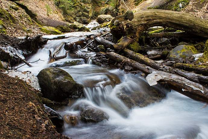
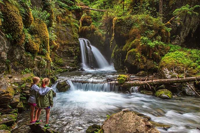
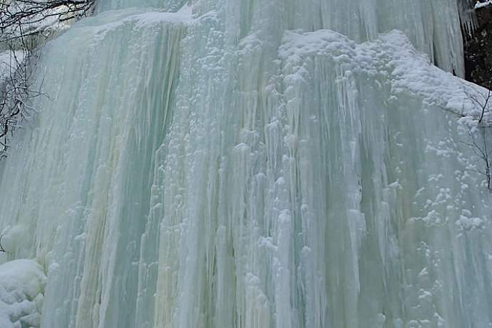
Falling about 200 feet through a chasm in the foothills of Chugach State Park, Thunderbird Falls is one of the most visited waterfalls in Alaska. Located up a short (and sometimes steep) one-mile trail through a handsome birch forest near the Eklutna River, the falls can easily be seen from a viewing deck. With some care for footing, you can take an access trail to the canyon floor and work upstream to the base to feel the chilly spray of Thunderbird Creek on your face. During winter, the falls usually freeze, forming ropey columns of ice. Take care that you have ice grippers on shoes after temperatures plunge. In all seasons, parents will want to be wary of the canyon lip and keep children well away.
Getting There
Take the Glenn Highway to the Thunderbird Falls exit near Mile 25, the first exit north of Mirror Lake. The trailhead is less than a mile north on the Old Glenn Highway. You can also exit at Eklutna: turn toward mountains and then drive south on the Old Glenn past the turnoff to Eklutna Lake. $5 fee or state parks parking pass is required. Outhouses available.
South Fork Falls (Barbara Falls)
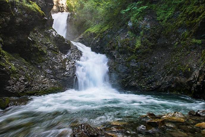
This hidden, little visited waterfall feels immense as it fills its small canyon with a roar that can be heard during the approach. Tucked into a gorge where the South Fork of Eagle River takes a 25-foot-plus plunge, the falls split into two channels as they cascade over a giant bedrock outcrop and are very photogenic. One of the Chugach’s secret places. The surrounding access trails are part of the Eagle River Greenbelt system, but private property lies very close. No bushwhacking! Want a guide? Go Hike Alaska offers guided walks to Barbara Falls year-round!
Getting There
Short version: The falls are about a half-mile walk on old roads from the end of Ken Logan Circle in a neighborhood off Hiland Road overlooking Eagle River Valley. The falls are a few hundred yards upstream from a small South Fork bridge. You will hear them long before you see them.
Long version: Take the Glenn Highway about 10 miles north to Eagle River Loop and exit toward the mountains. Almost immediately, turn right on Hiland Road. Continue uphill about 3.3 miles and turn left onto River View Drive into a neighborhood. Veer left as it becomes Waterfall Drive, then follow past a switchback until it dead-ends into River Park Drive. Continue right to Ken Logan Circle. Be careful where you park and obey the signs! Vehicles will be towed if parked illegally. Most of the circle is signed off-limits to parking.
From Ken Logan Circle, continue on foot past the gate about 100 yards to a bridge over the South Fork. Just before the bridge, a path descends to the creek and continues upstream several hundred yards to the base of the falls. To reach the overlook, continue on the trail another 250 yards to an intersection. Go right (uphill) and keep veering to your right, toward the creek, until you reach an old viewing area. A steep descent to the creek is possible but might require some down climbing. Total one-way walk to overlook is about half a mile.
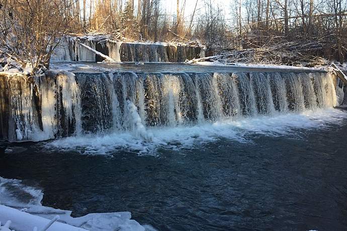
Ship Creek Dam (at the fish hatchery)
OK, this surge over dam spillways just above William Jack Hernandez Sport Fish Hatchery in Ship Creek’s industrial bottomland isn’t exactly a wild or natural sight. But if you and the family are intrigued by a human-engineered waterfall—complete with the roar and sparkle of cascading water—a visit to the hatchery grounds is a great diversion on a low-key afternoon in town. The water volume is high and cinematic, and the flow generates a big whoosh. It’s also a great excuse to explore state fish hatchery operations and take the self-guided museum quality tour of an operation that produces about six million fish a year to augment sport fishing in the region. Between June and September, returning Chinook and coho salmon may be swirling in the creek just downstream from the dam.
Getting There
The William Jack Hernandez hatchery is located on the banks of Ship Creek, east of the city’s industrial zone, at the corner of Reeve Boulevard and Post Road near the Post Road gate into Joint Base Elmendorf-Richardson. The easiest route: Take the Glenn Highway east from downtown and turn north onto Reeve Boulevard. The hatchery is about 9/10ths of a mile down the hill, on the right just after the Ship Creek bridge. Open to the public 8 AM to 4 PM.
McHugh Creek Falls
A foaming waterfall slices through a chute and tumbles about 20 feet into a pond just off the parking area and paved walkways of the McHugh Creek Day Use Area of Chugach State Park. This nicely laid out wayside features three parking lots, picnic areas, trailheads and restrooms—along with a Turnagain Arm vista that improves with each step up in elevation. Viewing spots and a handicap-accessible deck overlook the waterfall and its small-but-dramatic gorge, immediately connected to the second parking lot up the hill. It’s a dramatic perch, fascinating to kids. In general, the McHugh Creek area offers endless exploring potential—you can hike in at least six directions on existing trails. The crystal-clear creek is the front-country highlight. Above the falls, the stream descends a steep grade through its V-shaped valley, with lots of whitewater sections right off the bank. You will find plenty of secluded nooks to bask in the sensations of a wild, mountain stream right at your elbow.
Getting There
McHugh Creek is southeast of Anchorage at Mile 111 of the Seward Highway, overlooking Turnagain Arm about three miles beyond Potter Marsh. Lower parking lot is open year-round, while upper parking lots open during the snow-free season. $5 fee or state parks parking pass is required.
Virgin Creek Falls
If you’re in the mood for lush greenery, visit this pretty and energetic waterfall nestled in the Girdwood area rain forest on the same mountain that features the Alyeska Ski Resort. Many summer visitors say the primeval “Old Growth” setting may be the best part of the trip—Devil’s club, ferns, mossy logs and towering spruce. The falls themselves drop about 15 feet and are very loud. During winter, the falls armor in ice for a dramatic sight. A five-minute hike that’s great for kids and very close to other Girdwood attractions.
Getting There
From the Alyeska Highway in Girdwood, take Timberline Drive (first road on right after crossing Glacier Creek while driving toward the resort) until it ends. The unmarked trail follows the creek uphill about 150 yards to the falls.
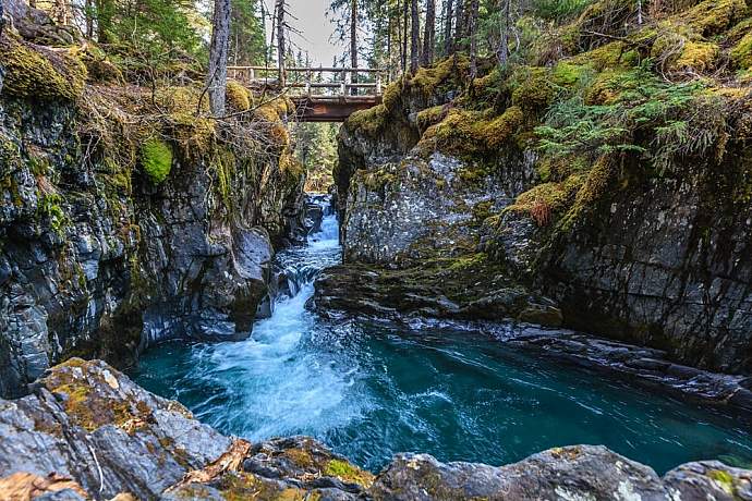
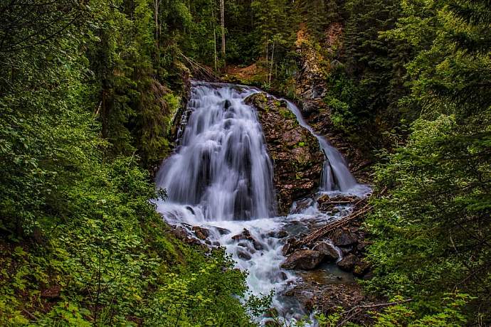
Winner Creek Gorge
A hike through a misty rain forest of towering trees in Girdwood Valley will bring you to a narrow wooden bridge over the dramatic slot where Winner Creek blasts through sheer rock walls. This sight is exotic and almost otherworldly—along with all the usual waterfall sensations, it offers a deep-woods, high adventure feel. (You’ll think you’re channeling your inner Indiana Jones.) You can also work your way down the creek on the west/north side to sit on boulders below the falls, next to the rolling creek. But the adventure isn’t over. For another kick, go just .2 miles further, where you will reach the hand tram and trolley over Glacier Creek. You can do the overlook and return the way you came, or can cross the creek by riding the tram and complete a journey to Crow Creek Mine or the 2.9-mile parking area on Crow Creek Road. The trail—maintained by Chugach National Forest as part of the historic Iditarod system—is mostly flat and family friendly—an unusual characteristic for outing into a place that has the aura of deep backcountry. Very popular with families.
Getting There
From Alyeska. Take the Winner Creek Trail about 3 miles from a trailhead behind the tram building at Alyeska Hotel. First .7 miles follows boardwalks and stairs into the foothills, then continues another .8 miles to a “T” intersection. Go left another mile to reach the Winner Creek Gorge, with the hand tram another .2 miles beyond. (Go right for Upper Winner Creek Trail, leading about 9 miles to Blueberry Pass and access to upper Twentymile River.)
From Crow Creek Road. Drive to the parking area at Mile 2.9 (second official parking area from the Alyeska Highway) about one half mile before the turnoff to Crow Creek Mine. Follow the well-marked trail system about one mile to the hand tram, then another .2 miles to the gorge. One-way distance to gorge: about 1.2 miles.
For more details, check out this map and fact sheet of Girdwood area trails.

Serenity Falls
This classic mountain waterfall plunges off a massive face in the valley beyond the head of Eklutna Lake in Chugach State Park. The free-fall plunge is hundreds of feet—some estimate it at 700 feet—but the stunning skein of whitewater descends its twisty defile more than a 1,200 feet from the alpine realm and makes for a dramatic photo when viewed from across the valley. Popular as an ice-climbing destination in winter, the falls maybe most spectacular in early summer when snowmelt boosts the volume. You’ll find great viewing from the deck of the Serenity Falls Hut, a multi-party public use cabin operated by state parks. Reaching the falls can be an all-day backcountry bike adventure over mostly flat trails and jeep roads. Doing an overnight at the Hut is an option that allows you to enjoy the fall’s music as the canyon grows dim in evening light.
Getting There
Exit the Glenn Highway at Eklutna at Mile 26.5 and drive ten miles to the state campground and day use area at the end of the road. Next you will need to bike, hike or (when open) use motorized transport another 13 miles on the Eklutna Lakeside Trail. Continue past the head of the lake at Mile 8 until you reach the turnoff to Serenity Falls Hut at Mile 12. Continue over the bridge another mile or so, until you see and hear the falls a few hundred feet into the woods. You can’t miss them.
Bird Creek Falls
This powerful, high-volume waterfall hides in a difficult-to-find gorge about 1.2 miles up Bird Creek from its mouth on Turnagain Arm. The falls themselves plunge about 20 feet into a pool—with the whole volume of Bird Creek exploding through a bedrock slot only a few yards across. In winter, the falls freeze into a stupendous ice curtain (seeps on a nearby rock wall also create a fantastic ice mural.) This is not a tourist-ready display: you will be down-climbing slippery slopes and sometimes crawling through brush to earn your waterfall fix. But if you are up for an adventure, and can handle route finding and some steep hiking descents, the falls are a scream. You will feel like you have endured an ordeal and found the treasure. Definitely one of Chugach State Park’s hidden gems.
Getting There
The falls are located where Bird Creek takes a dramatic jog to the west at the base of Bird Ridge, just over one mile upstream from the mouth. GPS: 60°59'3.58" N 149°26'48.55" W. Do not travel up the creek because the route crosses private property. Instead you must follow the Bird Creek Trail system from the trailhead at the end of Konikson Road (connects to Seward Highway at the Bird Creek Garage.) Best method might be to check out Bird Valley Trail Guide and work out your itinerary based on current trail conditions, Penguin Creek’s volume, and travel mode.
Trail notes: An obvious ATV trail will bring you to a precipitous bluff overlooking Bird Creek, about 1.5 miles from the trailhead. From this overlook, it’s another .4 miles on an unmaintained route to the falls. Work north along the bluff until you are past the slide area, then look for a steep route down to a bench. Descend and continue north to creek and look for another descent to the mouth of the gorge. Beware of bears in the creek bottom during salmon season.
Comments
Explore Further